Districts of Zimbabwe on:
[Wikipedia]
[Google]
[Amazon]
The 
 *
*
 *
*
 *
*
 * Bindura
* Guruve
* Mazowe
* Mbire
* Mount Darwin
* Muzarabani
* Mukumbura
* Rushinga
* Shamva
 *
*
 *
*
 * Bikita
*
 * Binga
* Bubi
* Hwange
* Lupane
* Nkayi
*
 *
*
 * Chirumhanzu
* Gokwe North
* Gokwe South
* Gweru
* Kwekwe
* Mberengwa
* Shurugwi
* Zvishavane
Map of Districts of Zimbabwe
{{Africa administrative divisions second level
Republic of Zimbabwe
Zimbabwe (), officially the Republic of Zimbabwe, is a landlocked country located in Southeast Africa, between the Zambezi and Limpopo Rivers, bordered by South Africa to the south, Botswana to the south-west, Zambia to the north, and Mozam ...
is broken down into 10 administrative provinces
A province is almost always an administrative division within a country or state. The term derives from the ancient Roman '' provincia'', which was the major territorial and administrative unit of the Roman Empire's territorial possessions ou ...
, which are divided into 59 districts and 1,200 wards.
Bulawayo Province
 *
* Bulawayo
Bulawayo (, ; Ndebele: ''Bulawayo'') is the second largest city in Zimbabwe, and the largest city in the country's Matabeleland region. The city's population is disputed; the 2022 census listed it at 665,940, while the Bulawayo City Council ...
Harare Province
 *
* Harare
Harare (; formerly Salisbury ) is the capital and most populous city of Zimbabwe. The city proper has an area of 940 km2 (371 mi2) and a population of 2.12 million in the 2012 census and an estimated 3.12 million in its metropolitan ...
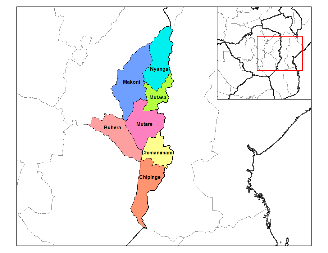
Manicaland Province
 *
* Buhera
Buhera is a village in Zimbabwe.
Location
Buhera District is in Manicaland Province, in eastern Zimbabwe. It is about , by road, southwest of Mutare, the location of the provincial headquarters. This location is approximately , southeast of C ...
* Chimanimani
Chimanimani is a town in Zimbabwe.
Location
Chimanimani is a village located in Manicaland Province, in south-eastern Zimbabwe, close to the border with Mozambique. The village lies about , by road, south of Mutare, the location of the provin ...
* Chipinge
Chipinge is a town in Zimbabwe, located in Chipinge District, in Manicaland Province, in southeastern Zimbabwe, close to the border with Mozambique.
Location
The town lies approximately , by road, south of Mutare, the nearest large city. Thi ...
* Makoni
* Mutare
Mutare (formerly Umtali) is the most populous city in the province of Manicaland, and the third most populous city in Zimbabwe, having surpassed Gweru in the 2012 census, with an urban population of 224,802 and approximately 260,567 in the surr ...
* Mutasa
* Nyanga
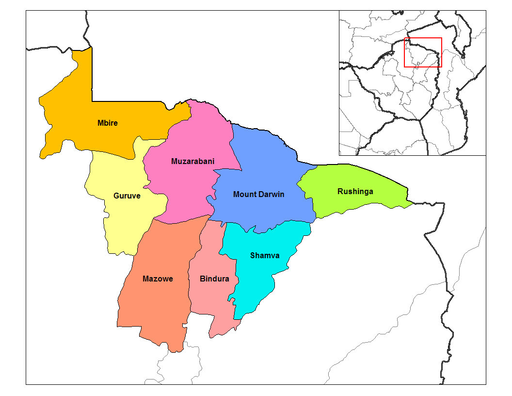
Mashonaland Central Province
 * Bindura
* Guruve
* Mazowe
* Mbire
* Mount Darwin
* Muzarabani
* Mukumbura
* Rushinga
* Shamva
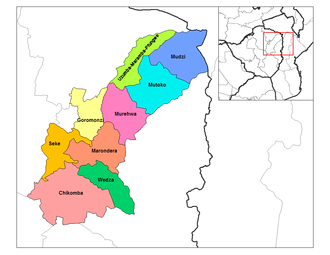
Mashonaland East Province
 *
* Chikomba
Chikomba is a district of Zimbabwe. It was previously part of Midlands Province, but was delimited to fall under Mashonaland East Province in the 1990s.
Notable people
*Chenjerai Hunzvi, politician and war veterans leader
*Solomon Mujuru, arm ...
* Goromonzi
Goromonzi is a rural community in East Mashonaland, Zimbabwe, southeast of the country's capital city of Harare., United States National Geospatial-Intelligence Agency The people are principally from the Shona
Shona often refers to:
* Shona ...
* Marondera
Marondera (known as Marandellas until 1982) is a city in Mashonaland East, Zimbabwe, located about 72 km east of Harare.
History
It was first known as Marandella's Kraal, corrupted from Marondera, chief of the ruling VaRozvi people who ...
* Mudzi
* Murehwa
* Mutoko
* Seke
* UMP (Uzumba-Maramba-Pfungwe)
* Wedza (Hwedza)
Mashonaland West Province
 *
* Chegutu
Chegutu (formerly Hartley) is a town in Mashonaland West Province, Zimbabwe.
Location
The town is located in Chegutu District, Mashonaland West, in central northern Zimbabwe. It lies in the Hartley Hills , southwest of the capital Harare at a ...
* Hurungwe
* Kariba
* Makonde
* Mhondoro-Ngezi
* Sanyati
* Zvimba
Zvimba District is a district of Mashonaland West Province, Zimbabwe.
Location
The district is located in Mashonaland West Province, in central northern Zimbabwe. Zvimba District is bordered by Guruve District to the north, Mazowe District to th ...
* Kadoma
* Chinhoyi
Masvingo Province
 * Bikita
*
 Chiredzi
Chiredzi is a town in Masvingo province in south-east Zimbabwe. It is located near the Runde River, which has a tributary called the ' Chiredzi'. As the administrative center for Chiredzi District, it is where both the rural and district counc ...
* Chivi
* Gutu
* Masvingo
* Mwenezi
* Zaka
ZAKA ( he, זק"א, abbreviation for ''Zihuy Korbanot Ason'', , literally: "Disaster Victim Identification") is a series of voluntary community emergency response teams in Israel, each operating in a police district (two in the Central Distric ...
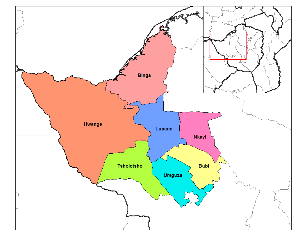
Matabeleland North Province
 * Binga
* Bubi
* Hwange
* Lupane
* Nkayi
*
 Tsholotsho
Tsholotsho is a district in Matabeleland North province in Zimbabwe. Its administrative centre is at Tsholotsho business centre which is located about 98 km north-west of Bulawayo. Districts around Tsholotsho include Lupane, Hwange, Umgu ...
* Umguza
Matabeleland South Province
 *
* Beitbridge
Beitbridge is a border town in the province of Matabeleland South, Zimbabwe. The name also refers to the border post and bridge spanning the Limpopo River, which forms the political border between South Africa and Zimbabwe. The border on the ...
* Bulilima
Bulilima District is a district of the Province Matabeleland South in Zimbabwe
Zimbabwe (), officially the Republic of Zimbabwe, is a landlocked country located in Southeast Africa, between the Zambezi and Limpopo Rivers, bordered by Sout ...
* Gwanda
Gwanda is a town in Zimbabwe. It is the capital of the province of Matabeleland South, one of the ten administrative provinces in the country. It is also the district capital of Gwanda District, one of the seven administrative districts in ...
* Insiza
* Mangwe
There are many different gods of rain in different religions:
African
African mythology
* Anẓar, god of rain in Berber mythology.
* Achek, wife of the rain god Deng in Dinka mythology
* Mangwe, a water spirit known as "the flooder" in the b ...
* Matobo
* Umzingwane
Midlands Province
 * Chirumhanzu
* Gokwe North
* Gokwe South
* Gweru
* Kwekwe
* Mberengwa
* Shurugwi
* Zvishavane
See also
* Provinces of Zimbabwe *Wards of Zimbabwe
The Districts of Zimbabwe are divided into 1,200 municipal wards. The wards are listed below, by district: Kenilworth is under Bubi district There is a high school Mangubeni high Where Pretty Ndlovu the last daughter of war veteran Mack Mackie ...
External links
Map of Districts of Zimbabwe
{{Africa administrative divisions second level
Zimbabwe
Zimbabwe (), officially the Republic of Zimbabwe, is a landlocked country located in Southeast Africa, between the Zambezi and Limpopo Rivers, bordered by South Africa to the south, Botswana to the south-west, Zambia to the north, and ...
Zimbabwe
Zimbabwe (), officially the Republic of Zimbabwe, is a landlocked country located in Southeast Africa, between the Zambezi and Limpopo Rivers, bordered by South Africa to the south, Botswana to the south-west, Zambia to the north, and ...
Zimbabwe
Zimbabwe (), officially the Republic of Zimbabwe, is a landlocked country located in Southeast Africa, between the Zambezi and Limpopo Rivers, bordered by South Africa to the south, Botswana to the south-west, Zambia to the north, and ...
Subdivisions of Zimbabwe
Zimbabwe geography-related lists