Cley Hill on:
[Wikipedia]
[Google]
[Amazon]
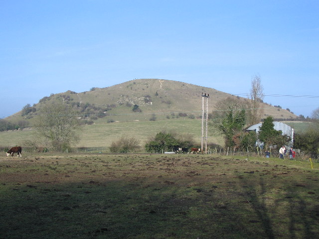
 Cley Hill () is a prominent hill to the west of
  There is a legend that the hill was formed by the devil, when he dropped a sack of earth with which he had planned to bury the town of
Natural England website
(SSSI information)
SSSI boundary at Defras Magic Map website
Sites of Special Scientific Interest in Wiltshire Sites of Special Scientific Interest notified in 1975 Hills of Wiltshire Hill forts in Wiltshire National Trust properties in Wiltshire Scheduled monuments in Wiltshire {{England-SSSI-stub
 Cley Hill () is a prominent hill to the west of
 Warminster
Warminster () is an ancient market town with a nearby garrison, and civil parish in south west Wiltshire, England, on the western edge of Salisbury Plain. The parish had a population of about 17,000 in 2011. The 11th-century Minster Church o ...
in Wiltshire
Wiltshire (; abbreviated Wilts) is a historic and ceremonial county in South West England with an area of . It is landlocked and borders the counties of Dorset to the southwest, Somerset to the west, Hampshire to the southeast, Gloucestershire ...
, England. Its summit has a commanding view of the Wiltshire / Somerset county boundary, at elevation. The land is in Corsley
Corsley is a hamlet and civil parish west of Warminster in Wiltshire, England. The parish is on the county border with Somerset; the Somerset town of Frome is about to the northwest. The largest settlement in the parish is Corsley Heath, which ...
parish and is owned by the National Trust
The National Trust, formally the National Trust for Places of Historic Interest or Natural Beauty, is a charity and membership organisation for heritage conservation in England, Wales and Northern Ireland. In Scotland, there is a separate and ...
.
A area of chalk grassland
Calcareous grassland (or alkaline grassland) is an ecosystem associated with thin basic soil, such as that on chalk and limestone downland. Plants on calcareous grassland are typically short and hardy, and include grasses and herbs such as clover ...
at Cley Hill was notified as a biological Site of Special Scientific Interest
A Site of Special Scientific Interest (SSSI) in Great Britain or an Area of Special Scientific Interest (ASSI) in the Isle of Man and Northern Ireland is a conservation designation denoting a protected area in the United Kingdom and Isle of ...
in 1975. The land is managed by the National Trust, having been donated to the charity in 1954 by the 6th Marquess of Bath.
Archaeological features include a large univallate Iron Age
The Iron Age is the final epoch of the three-age division of the prehistory and protohistory of humanity. It was preceded by the Stone Age ( Paleolithic, Mesolithic, Neolithic) and the Bronze Age ( Chalcolithic). The concept has been mostly ...
hill fort
A hillfort is a type of earthwork used as a fortified refuge or defended settlement, located to exploit a rise in elevation for defensive advantage. They are typically European and of the Bronze Age or Iron Age. Some were used in the post-Roma ...
, two bowl barrow
A bowl barrow is a type of burial mound or tumulus. A barrow is a mound of earth used to cover a tomb. The bowl barrow gets its name from its resemblance to an upturned bowl. Related terms include ''cairn circle'', ''cairn ring'', ''howe'', ''ker ...
s and medieval strip lynchet
A lynchet or linchet is an earth terrace found on the side of a hill. Lynchets are a feature of ancient field systems of the British Isles. They are commonly found in vertical rows and more commonly referred to as "strip lynchets". Lynchets appe ...
s.
 There is a legend that the hill was formed by the devil, when he dropped a sack of earth with which he had planned to bury the town of
 Devizes
Devizes is a market town and civil parish in Wiltshire, England. It developed around Devizes Castle, an 11th-century Norman castle, and received a charter in 1141. The castle was besieged during the Anarchy, a 12th-century civil war between ...
. He had retrieved the earth from Somerset and was travelling to Devizes when he stopped to ask an old man the distance to the town. The man replied that he had been walking for years to reach Devizes, so the devil abandoned his plan.
References
External links
Natural England website
(SSSI information)
SSSI boundary at Defras Magic Map website
Sites of Special Scientific Interest in Wiltshire Sites of Special Scientific Interest notified in 1975 Hills of Wiltshire Hill forts in Wiltshire National Trust properties in Wiltshire Scheduled monuments in Wiltshire {{England-SSSI-stub