Caterham and Warlingham on:
[Wikipedia]
[Google]
[Amazon]
 Caterham and Warlingham was an Urban District of Surrey in
 Caterham and Warlingham was an Urban District of Surrey in
 England
England is a country that is part of the United Kingdom. It shares land borders with Wales to its west and Scotland to its north. The Irish Sea lies northwest and the Celtic Sea to the southwest. It is separated from continental Europe b ...
until 1974.
Geographic evolution
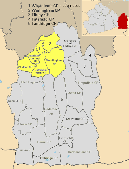
It was pre-emptively formed shortly before the major national 1933 reforms of boundaries and entities accordingly to take account of population change, in 1929. It was a merger of theCaterham
Caterham () is a town in the Tandridge District of Surrey, England. The town is administratively divided into two: Caterham on the Hill, and Caterham Valley, which includes the main town centre in the middle of a dry valley but rises to equal ...
Urban District with the similar North Downs
The North Downs are a ridge of chalk hills in south east England that stretch from Farnham in Surrey to the White Cliffs of Dover in Kent. Much of the North Downs comprises two Areas of Outstanding Natural Beauty (AONBs): the Surrey Hills a ...
civil parish of Warlingham
Warlingham is a village in the Tandridge district of Surrey, England, south of the centre of London and east of the county town, Guildford. Warlingham is the centre of a civil parish that includes Hamsey Green, a contiguous, smaller sett ...
to the east and more rural and entirely hilltop civil parish of Woldingham
Woldingham is a village and civil parish high on the North Downs between Oxted and Warlingham in Surrey, England, within the M25, southeast of London. The village has 2,141 inhabitants, many of whom commute to London, making Woldingham part o ...
from Godstone Rural District to the south-east.
In 1933 the Urban District absorbed the narrow majority, the entirely hilltop segment, of Chaldon
Chaldon is a village and civil parish in the Tandridge District of Surrey, England. The village is situated high on the North Downs, immediately west of Caterham and south of Charing Cross, the traditional centre of London.
History Etymology a ...
to the west from defunct Reigate Rural District, in so doing, the contributor parish shedding to the parish of Bletchingley and to Coulsdon to the south and north respectively.
An urban and suburban area of equal contribution between the two merged areas finally became a later civil parish after the area's abolition, Whyteleafe
Whyteleafe is a village in the district of Tandridge, Surrey, England, with a few streets falling inside the London Borough of Croydon. The village, in a dry valley of the North Downs, has three railway stations (on two parallel lines). Neighbouri ...
which had already its own railway station and church; it was throughout the district's duration identifiable as a village.Caterham and Warlingham at Vision of BritainAbolition
Caterham and Warlingham was abolished in 1974 due to the Local Government Act 1972 to form the north-west of theTandridge (district)
Tandridge is a local government district in east Surrey, England. Its council is based in Oxted, although the largest settlement is Caterham; other notable settlements include Warlingham, Godstone and Lingfield. In mid-2019, the district had a ...
which is the easternmost part of the county and covers a much larger area, shown in red in the inset map and in grey and yellow in the main section of map.
References
{{coord, 51.30, -0.06, type:adm3rd_dim:7000_region:GB-SRY, display=title Districts of England abolished by the Local Government Act 1972 History of Surrey Urban districts of England 1929 establishments in England