Barpa Langass on:
[Wikipedia]
[Google]
[Amazon]
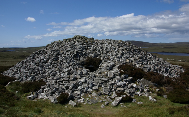
 Barpa Langass (also known as Langass Barp or Langash Barp; gd, Barpa Langais ), is a
 Barpa Langass (also known as Langass Barp or Langash Barp; gd, Barpa Langais ), is a
 Neolithic
The Neolithic period, or New Stone Age, is an Old World archaeological period and the final division of the Stone Age. It saw the Neolithic Revolution, a wide-ranging set of developments that appear to have arisen independently in several p ...
chambered cairn on the Isle of North Uist
North Uist ( gd, Uibhist a Tuath; sco, North Uise) is an island and community in the Outer Hebrides of Scotland.
Etymology
In Donald Munro's ''A Description of the Western Isles of Scotland Called Hybrides'' of 1549, North Uist, Benbecula and ...
in the Outer Hebrides of Scotland. It measures about 72 feet in diameter by 18 feet in height, and is around 5,000 years old. The roof is constructed of two massive slabs with a third slab superimposed.
The entrance is at the east side. Although the structure has partially collapsed, it is still possible to enter one chamber. The antiquary Erskine Beveridge believed that a second and perhaps a third chamber exist. In or prior to 1911, Dr Beveridge excavated within and near the cairn, and he found evidence of burnt burials as well as pieces of pottery (some with patterned lines), wood ashes, burnt bones, a flint arrowhead
An arrowhead or point is the usually sharpened and hardened tip of an arrow, which contributes a majority of the projectile mass and is responsible for impacting and penetrating a target, as well as to fulfill some special purposes such as sign ...
, a scraper, and a piece of pierced talc
Talc, or talcum, is a clay mineral, composed of hydrated magnesium silicate with the chemical formula Mg3Si4O10(OH)2. Talc in powdered form, often combined with corn starch, is used as baby powder. This mineral is used as a thickening agent a ...
.
Barpa Langass is located at grid reference
A projected coordinate system, also known as a projected coordinate reference system, a planar coordinate system, or grid reference system, is a type of spatial reference system that represents locations on the Earth using cartesian coordin ...
NF838657 ()(57.570581, -7.291557). It can be reached via footpath from the A867 about 5 miles southwest of Lochmaddy
Lochmaddy ( gd, Loch nam Madadh, "Loch of the Hounds") is the administrative centre of North Uist in the Outer Hebrides, Scotland. ''Na Madaidhean'' (the wolves/hounds) are rocks in the bay after which the loch, and subsequently the village, are ...
. Alternatively, one can park at the Langass Lodge Hotel, follow the footpath to the Pobull Fhinn stone circle, and then continue up Ben Langass to Barpa Langass.
See also
* Cladh Hallan - aBronze Age
The Bronze Age is a historic period, lasting approximately from 3300 BC to 1200 BC, characterized by the use of bronze, the presence of writing in some areas, and other early features of urban civilization. The Bronze Age is the second prin ...
site on South Uist
South Uist ( gd, Uibhist a Deas, ; sco, Sooth Uist) is the second-largest island of the Outer Hebrides in Scotland. At the 2011 census, it had a usually resident population of 1,754: a decrease of 64 since 2001. The island, in common with the ...
References
Sources
* * *External links
* {{Authority control 4th-millennium BC architecture in Scotland Megalithic monuments in Scotland Archaeological sites in the Outer Hebrides Scheduled monuments in Scotland North Uist Chambered cairns in Scotland