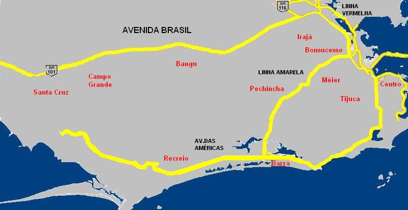
Avenida Brasil (Rio de Janeiro) on:
[Wikipedia]
[Google]
[Amazon]
 Avenida Brasil is an expressway-like thoroughfare in
Rio de Janeiro
Rio de Janeiro ( , , ; literally 'River of January'), or simply Rio, is the capital of the state of the same name, Brazil's third-most populous state, and the second-most populous city in Brazil, after SĂŁo Paulo. Listed by the GaWC as a b ...
. Its emergence is associated with the expansion of the city to residential areas further away from its central region during the first half of the 20th century. It started to serve as a gateway by road, hitherto hitched by sea or by the path taken by trains. The avenue that was linked to PetrĂłpolis in 1941 became the first federal highway (BR-01) in 1948.
At , it is the biggest avenue in extension in Brazil
Brazil ( pt, Brasil; ), officially the Federative Republic of Brazil (Portuguese: ), is the largest country in both South America and Latin America. At and with over 217 million people, Brazil is the world's fifth-largest country by area ...
, as well as the largest urban track of BR-101
The BR-101 (also called ''Translitorânea'' (transcoastal), officially named ''Rodovia Governador Mário Covas''.
Only one stretch, of 2.3 kilometers, is exclusively named "Avenida Brasil", which is between Avenida JoĂŁo XXIII, in Santa Cruz, Rio de Janeiro, Santa Cruz, and the access to the BR-101 highway, in the same neighborhood.
It is the longest avenue in extension in Brazil and the longest urban stretch of the BR-101 , connecting the BR-101 north ( Ponte Rio-NiterĂłi and Rodovia Rio-VitĂłria/NiterĂłi-Manilha) to the BR-101 south (Rodovia Rio-Santos). Its speed limit is up to 90 kilometers per hour; however, the average speed on the expressway significantly decreases because of traffic jams
In addition to BR-101, Avenida Brasil is also part of the BR-040,
BR-116
BR-116 is a federal route of highways of Brazil and the longest highway in the country, with of extension. The road connect Fortaleza, Ceará, one of the largest Northeast Brazil metropolises, to the southern city of Jaguarão, Rio Grande do S ...
and BR-465 routes, totaling all federal highways that pass through the city of Rio de Janeiro.
The City Hall of Rio de Janeiro measures Avenida Brasil as being responsible for the largest traffic flow in the city, with more than 800 thousand vehicles per day, attributed to the geographic influence of the road - caused by the phenomenon of pendular migration, that is, the daily movement of vehicles. workers from Baixada Fluminense
The Baixada Fluminense (standard ; local pronounce: ) (literally "Fluminense Lowland") is a region in the state of Rio de Janeiro, in southeastern Brazil. It is located on Guanabara Bay, between Rio de Janeiro to the south and the Serra dos Ă“rgĂ ...
and from Zona Norte and Zona Oeste to the Center of the city.
References
Streets in Rio de Janeiro (city) Highways in Rio de Janeiro (state) {{brazil-road-stub