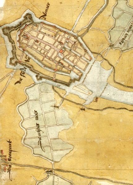
Achtermeer on:
[Wikipedia]
[Google]
[Amazon]
The Achtermeer
Ghostarchive
and th
Wayback Machine
{{cbignore maintained the water level in the Overdie and Achtermeer polders. Since 1994, that pumping station has been a Provincial Monument; it still functions in times of exceptionally high water. (The black arrow in the recent map indicates the location of the pumping station.)

polder
A polder () is a low-lying tract of land that forms an artificial hydrological entity, enclosed by embankments known as dikes. The three types of polder are:
# Land reclaimed from a body of water, such as a lake or the seabed
# Flood plains ...
, south of Alkmaar
Alkmaar () is a city and municipality in the Netherlands, located in the province of North Holland, about 30 km north of Amsterdam. Alkmaar is well known for its traditional cheese market. For tourists, it is a popular cultural destination. The ...
in the Dutch province of North Holland
North Holland ( nl, Noord-Holland, ) is a province of the Netherlands in the northwestern part of the country. It is located on the North Sea, north of South Holland and Utrecht, and west of Friesland and Flevoland. In November 2019, it had a ...
, is the first known polder in the Netherlands
)
, anthem = ( en, "William of Nassau")
, image_map =
, map_caption =
, subdivision_type = Sovereign state
, subdivision_name = Kingdom of the Netherlands
, established_title = Before independence
, established_date = Spanish Netherl ...
.
History
In 1532, EmperorCharles V Charles V may refer to:
* Charles V, Holy Roman Emperor (1500–1558)
* Charles V of Naples (1661–1700), better known as Charles II of Spain
* Charles V of France (1338–1380), called the Wise
* Charles V, Duke of Lorraine (1643–1690)
* Infa ...
granted the permit to drain the forty-hectare lake. The draining was completed in 1533.
In 1573 the polder was flooded again for a short period. Partly because of that, the Spaniards, who had their camp there, had to give up the Siege of Alkmaar
The siege of Alkmaar (1573) was a turning point in the Eighty Years' War. The burghers of the Dutch city of Alkmaar held off the Spanish (who had set up their camp in Oudorp) between 21 August and 8 October 1573, with boiling tar and burning b ...
. This was an early victory for the Dutch in the Eighty Years' War
The Eighty Years' War or Dutch Revolt ( nl, Nederlandse Opstand) ( c.1566/1568–1648) was an armed conflict in the Habsburg Netherlands between disparate groups of rebels and the Spanish government. The causes of the war included the Ref ...
.
From 1709 the mill of the Achtermeer also kept the Overdie polder dry. Together with the Klappolder, which was added a few years later, the Water Board
A water board is a regional or national organisation that has very different functions from one country to another. The functions range from flood control and water resources management at the regional or local level (the Netherlands, Germany), w ...
of the Overdie and Achtermeer polders took its definitive form. The Water Board was abolished in 1962. The area is now managed by the Hoogheemraadschap Hollands Noorderkwartier. This water board manages the original 352 water boards still existing in 1931.
After the Second World War
World War II or the Second World War, often abbreviated as WWII or WW2, was a world war that lasted from 1939 to 1945. It involved the vast majority of the world's countries—including all of the great powers—forming two opposi ...
, a residential area was built in the polder, so it is now entirely within the built-up area of Alkmaar. When planning this new neighbourhood, the subdivision and the polder ditches were the starting point for the street pattern. Parts of the ring canal have been preserved.
The mill burned down in 1912. From 1913 to 1988, the Alkmaar Diesel pumping stationArchived aGhostarchive
and th
Wayback Machine
{{cbignore maintained the water level in the Overdie and Achtermeer polders. Since 1994, that pumping station has been a Provincial Monument; it still functions in times of exceptionally high water. (The black arrow in the recent map indicates the location of the pumping station.)


References