|
Nez Perce People
The Nez Percé (; autonym in Nez Perce language: , meaning "we, the people") are an Indigenous people of the Plateau who are presumed to have lived on the Columbia River Plateau in the Pacific Northwest region for at least 11,500 years.Ames, Kenneth and Alan Marshall. 1980. "Villages, Demography and Subsistence Intensification on the Southern Columbia Plateau". ''North American Archeologist'', 2(1): 25–52." Members of the Sahaptin language group, the Nimíipuu were the dominant people of the Columbia Plateau for much of that time, especially after acquiring the horses that led them to breed the appaloosa horse in the 18th century. Prior to first contact with European colonial people the Nimiipuu were economically and culturally influential in trade and war, interacting with other indigenous nations in a vast network from the western shores of Oregon and Washington, the high plains of Montana, and the northern Great Basin in southern Idaho and northern Nevada. Frenc ... [...More Info...] [...Related Items...] OR: [Wikipedia] [Google] [Baidu] |
George Catlin
George Catlin (July 26, 1796 – December 23, 1872) was an American adventurer, lawyer, painter, author, and traveler, who specialized in portraits of Native Americans in the Old West. Traveling to the American West five times during the 1830s, Catlin wrote about and painted portraits that depicted the life of the Plains Indians. His early work included engravings, drawn from nature, of sites along the route of the Erie Canal in New York State. Several of his renderings were published in one of the first printed books to use lithography, Cadwallader D. Colden's ''Memoir, Prepared at the Request of a Committee of the Common Council of the City of New York, and Presented to the Mayor of the City, at the Celebration of the Completion of the New York Canals'', published in 1825, with early images of the City of Buffalo. Background and education George Catlin was born in 1796 in Wilkes-Barre, Luzerne County, Pennsylvania. While growing up, George encountered "trappers, hunters ... [...More Info...] [...Related Items...] OR: [Wikipedia] [Google] [Baidu] |
Nevada
Nevada ( ; ) is a state in the Western region of the United States. It is bordered by Oregon to the northwest, Idaho to the northeast, California to the west, Arizona to the southeast, and Utah to the east. Nevada is the 7th-most extensive, the 32nd-most populous, and the 9th-least densely populated of the U.S. states. Nearly three-quarters of Nevada's people live in Clark County, which contains the Las Vegas–Paradise metropolitan area, including three of the state's four largest incorporated cities. Nevada's capital is Carson City. Las Vegas is the largest city in the state. Nevada is officially known as the "Silver State" because of the importance of silver to its history and economy. It is also known as the "Battle Born State" because it achieved statehood during the Civil War (the words "Battle Born" also appear on its state flag); as the " Sagebrush State", for the native plant of the same name; and as the " Sage-hen State". The name means "snowy" in Spanish, re ... [...More Info...] [...Related Items...] OR: [Wikipedia] [Google] [Baidu] |
Orofino, Idaho
Orofino (''"fine gold"'' rein Spanish) is a city in and the county seat of Clearwater County, Idaho, along Orofino Creek and the north bank of the Clearwater River. It is the major city within the Nez Perce Indian Reservation. The population was 3,142 at the time of the 2010 census. Nearby is the historical "Canoe Camp," where the Lewis and Clark expedition built five new dugout canoes and embarked on October 7, 1805, downstream to the Pacific Ocean. Some north is the Dworshak Dam, third-highest dam in the United States, completed in the early 1970s. Nearby is the Dworshak National Fish Hatchery, started to try to compensate for the loss of migratory fish upstream after the dam was constructed. Originally the name was two words, Oro Fino, applied to a gold mining camp established in 1861 south of Pierce; it is now a ghost town. When the United States government opened up the Nez Percé reservation to non-tribal settlers in 1895, thousands of European Americans rushed to ... [...More Info...] [...Related Items...] OR: [Wikipedia] [Google] [Baidu] |
Dworshak National Fish Hatchery
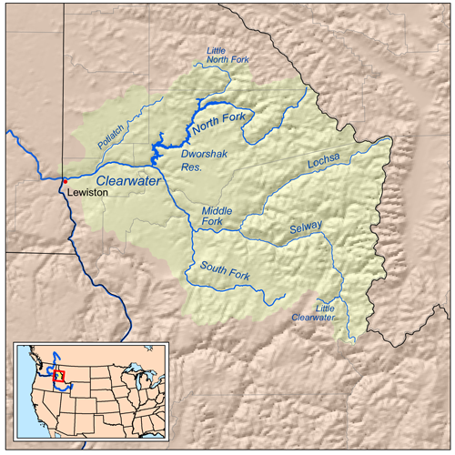
Dworshak National Fish Hatchery is a mitigation hatchery located on the Clearwater River within the Nez Perce Reservation near Ahsahka, in north-central Idaho, United States. It was constructed in 1969 by the Army Corps of Engineers, and is co-managed by the U.S. Fish and Wildlife Service and the Nez Perce Tribe. The hatchery is one of the largest combination producers of anadromous (migratory) fish in the world. These fish make a 1000-mile round trip to the ocean and back to spawn in the Clearwater River. The Dworshak Dam blocks access to the historical spawning areas on the North Fork-Clearwater River for the steelhead, and it is too high for a fish ladder. Steelhead, chinook and coho salmon The coho salmon (''Oncorhynchus kisutch;'' Karuk: achvuun) is a species of anadromous fish in the salmon family (biology), family and one of the five Pacific salmon species. Coho salmon are also known as silver salmon or "silvers". The scientif ... are spawned and reared at the facil ... [...More Info...] [...Related Items...] OR: [Wikipedia] [Google] [Baidu] |
Kooskia, Idaho
Kooskia ( ) is a city in Idaho County, Idaho, United States. It is at the confluence of the South and Middle forks of the Clearwater River, combining to become the main river. The population was 607 at the 2010 census, down from 675 in 2000. History Chief Looking Glass lived in a village a short distance above what is now Kooskia with his band of Nez Perce. This regular home was well within the boundaries of the reservation created in 1863, but just before the Nez Perce War an American General was sent to arrest Chief Looking Glass and all other Nez Perce with him. When trigger-happy militiamen opened fire into the village, many Nez Perce died and their village was destroyed in the scuffle. Because of this incident, Looking Glass joined with the Nez Perce for the Nez Perce War. The name of the town is likely a contraction of the Nez Perce word "koos-koos-kia," a diminutive which refers to the Clearwater River, the lesser of the two large rivers in the vicinity, the other bein ... [...More Info...] [...Related Items...] OR: [Wikipedia] [Google] [Baidu] |
Kooskia National Fish Hatchery
Kooskia National Fish Hatchery is a "mitigation" hatchery located on the Clearwater River within the Nez Perce Indian Reservation near Kooskia, in north-central Idaho. Construction began in 1966 by the Army Corps of Engineers. With funding provided by the United States per a water rights settlement the hatchery is managed and operated by the Nez Perce Tribe. The production goal is to raise and release up to 600,000 juvenile spring Chinook salmon annually. The fish hatchery was the site of Looking Glass's village which was attacked on July 1, 1877 by U.S. army soldiers. Looking Glass subsequently joined Chief Joseph to become a leader in the Nez Perce War The Nez Perce War was an armed conflict in 1877 in the Western United States that pitted several bands of the Nez Perce tribe of Native Americans and their allies, a small band of the ''Palouse'' tribe led by Red Echo (''Hahtalekin'') and .... A plaque describing the event and a nature trail on the site have be ... [...More Info...] [...Related Items...] OR: [Wikipedia] [Google] [Baidu] |
Lapwai, Idaho
Lapwai is a city in the northwest United States, in Nez Perce County, Idaho. Its population was 1,137 at the 2010 census, and it is the seat of government of the Nez Perce Indian Reservation. Lapwai actually means "The land of the butterflies" History The area that is today Lapwai was the home of Hin-ma-tute-ke-kaikt, also known as Big Thunder and later as James. It was here that Henry Spalding established a Protestant mission among the Nez Perce in 1836. This was also the general region that Bill Craig settled, since his wife was James' daughter. The city's predecessor, Fort Lapwai, operated on the site from 1863 to 1884. The village of Lapwai was incorporated in 1911, with a model rural school. The word "Lapwai" means place of the butterflies, as the area had thousands in early summer in earlier years. Lapwai is part of the Lewiston, ID- WA Metropolitan Statistical Area. Geography Lapwai is located at (46.404388, -116.804376)., at an elevation of above sea level Ac ... [...More Info...] [...Related Items...] OR: [Wikipedia] [Google] [Baidu] |
Indian Reservation
An Indian reservation is an area of land held and governed by a federally recognized Native American tribal nation whose government is accountable to the United States Bureau of Indian Affairs and not to the state government in which it is located. Some of the country's 574 federally recognized tribes govern more than one of the 326 Indian reservations in the United States, while some share reservations, and others have no reservation at all. Historical piecemeal land allocations under the Dawes Act facilitated sales to non–Native Americans, resulting in some reservations becoming severely fragmented, with pieces of tribal and privately held land being treated as separate enclaves. This jumble of private and public real estate creates significant administrative, political and legal difficulties. The total area of all reservations is , approximately 2.3% of the total area of the United States and about the size of the state of Idaho. While most reservations are small ... [...More Info...] [...Related Items...] OR: [Wikipedia] [Google] [Baidu] |
Federally Recognized Tribe
This is a list of federally recognized tribes in the contiguous United States of America. There are also federally recognized Alaska Native tribes. , 574 Indian tribes were legally recognized by the Bureau of Indian Affairs (BIA) of the United States.Federal Acknowledgment of the Pamunkey Indian Tribe Of these, 231 are located in Alaska. Description  In the United States, the Indian tribe is a fundamental unit, and the constitution grants
|
Dawes Act Of 1887
The Dawes Act of 1887 (also known as the General Allotment Act or the Dawes Severalty Act of 1887) regulated land rights on tribal territories within the United States. Named after Senator Henry L. Dawes of Massachusetts, it authorized the President of the United States to subdivide Native American tribal communal landholdings into allotments for Native American heads of families and individuals. This would convert traditional systems of land tenure into a government-imposed system of private property by forcing Native Americans to "assume a capitalist and proprietary relationship with property" that did not previously exist in their cultures. The act allowed tribes the option to sell the lands that remained after allotment to the federal government. Before private property could be dispensed, the government had to determine "which Indians were eligible" for allotments, which propelled an "official search for a federal definition of Indian-ness." Although the act was passed in ... [...More Info...] [...Related Items...] OR: [Wikipedia] [Google] [Baidu] |
Nez Perce War
The Nez Perce War was an armed conflict in 1877 in the Western United States that pitted several bands of the Nez Perce tribe of Native Americans and their allies, a small band of the ''Palouse'' tribe led by Red Echo (''Hahtalekin'') and Bald Head (''Husishusis Kute''), against the United States Army. Fought between June and October, the conflict stemmed from the refusal of several bands of the Nez Perce, dubbed "non-treaty Indians," to give up their ancestral lands in the Pacific Northwest and move to an Indian reservation in Idaho Territory. This forced removal was in violation of the 1855 Treaty of Walla Walla, which granted the tribe 7.5 million acres of their ancestral lands and the right to hunt and fish on lands ceded to the U.S. government. After the first armed engagements in June, the Nez Perce embarked on an arduous trek north initially to seek help with the Crow tribe. After the Crows' refusal of aid, they sought sanctuary with the Lakota led by Sitting Bul ... [...More Info...] [...Related Items...] OR: [Wikipedia] [Google] [Baidu] |
Indian Territory
The Indian Territory and the Indian Territories are terms that generally described an evolving land area set aside by the United States Government for the relocation of Native Americans who held aboriginal title to their land as a sovereign independent state. In general, the tribes ceded land they occupied in exchange for land grants in 1803. The concept of an Indian Territory was an outcome of the US federal government's 18th- and 19th-century policy of Indian removal. After the American Civil War (1861–1865), the policy of the US government was one of assimilation. The term ''Indian Reserve'' describes lands the British set aside for Indigenous tribes between the Appalachian Mountains and the Mississippi River in the time before the American Revolutionary War (1775–1783). Indian Territory later came to refer to an unorganized territory whose general borders were initially set by the Nonintercourse Act of 1834, and was the successor to the remainder of the Missouri T ... [...More Info...] [...Related Items...] OR: [Wikipedia] [Google] [Baidu] |


.png)
.jpg)

.jpg)


