|
Global Positioning System
The Global Positioning System (GPS), originally Navstar GPS, is a satellite-based radionavigation system owned by the United States government and operated by the United States Space Force. It is one of the global navigation satellite systems (GNSS) that provides geolocation and time information to a GPS receiver anywhere on or near the Earth where there is an unobstructed line of sight to four or more GPS satellites. It does not require the user to transmit any data, and operates independently of any telephonic or Internet reception, though these technologies can enhance the usefulness of the GPS positioning information. It provides critical positioning capabilities to military, civil, and commercial users around the world. Although the United States government created, controls and maintains the GPS system, it is freely accessible to anyone with a GPS receiver. The GPS project was started by the U.S. Department of Defense in 1973. The first prototype spacecraft was lau ... [...More Info...] [...Related Items...] OR: [Wikipedia] [Google] [Baidu] |
United States Space Force
The United States Space Force (USSF) is the space service branch of the U.S. Armed Forces, one of the eight U.S. uniformed services, and the world's only independent space force. Along with its sister branch, the U.S. Air Force, the Space Force is part of the Department of the Air Force, one of the three civilian-led military departments within the Department of Defense. The Space Force, through the Department of the Air Force, is overseen by the secretary of the Air Force, a civilian political appointee who reports to the secretary of defense, and is appointed by the president with Senate confirmation. The military head of the Space Force is the chief of space operations who is typically the most senior Space Force officer. The chief of space operations exercises supervision over the Space Force's units and serves as one of the Joint Chiefs of Staff. The Space Force is the smallest U.S. armed service, consisting of 8,400 military personnel. The Space Force operates 77 ... [...More Info...] [...Related Items...] OR: [Wikipedia] [Google] [Baidu] |
GPS Block IIIA
GPS Block III (previously Block IIIA) consists of the first ten GPS III satellites, which will be used to keep the Navstar Global Positioning System operational. Lockheed Martin designed, developed and manufactured the GPS III Non-Flight Satellite Testbed (GNST) and all ten Block III satellites. The first satellite in the series was launched in December 2018. The tenth and final GPS Block III launch is projected in 2023. History The United States' Global Positioning System (GPS) reached Full Operational Capability on 17 July 1995, completing its original design goals. Advances in technology and new demands on the existing system led to the effort to modernize the GPS system. In 2000, the U.S. Congress authorized the effort, referred to as GPS III. The project involves new ground stations and new satellites, with additional navigation signals for both civilian and military users, and aims to improve the accuracy and availability for all users. Raytheon was awarded the Ne ... [...More Info...] [...Related Items...] OR: [Wikipedia] [Google] [Baidu] |
Satellite-based Augmentation System
Augmentation of a global navigation satellite system (GNSS) is a method of improving the navigation system's attributes, such as precision, reliability, and availability, through the integration of external information into the calculation process. There are many such systems in place, and they are generally named or described based on how the GNSS sensor receives the external information. Some systems transmit additional information about sources of error (such as clock drift, ephemeris, or ionospheric delay), others provide direct measurements of how much the signal was off in the past, while a third group provides additional vehicle information to be integrated in the calculation process. Satellite-based augmentation system Satellite-based augmentation systems (SBAS) support wide-area or regional augmentation through the use of additional satellite-broadcast messages. Using measurements from the ground stations, correction messages are created and sent to one or more satell ... [...More Info...] [...Related Items...] OR: [Wikipedia] [Google] [Baidu] |
Quasi-Zenith Satellite System
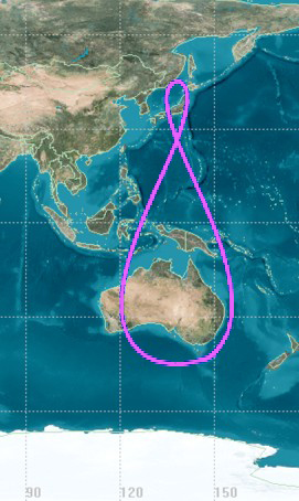
The Quasi-Zenith Satellite System (QZSS), also known as , is a four-satellite regional time transfer system and a satellite-based augmentation system developed by the Japanese government to enhance the United States-operated Global Positioning System (GPS) in the Asia-Oceania regions, with a focus on Japan. The goal of QZSS is to provide highly precise and stable positioning services in the Asia-Oceania region, compatible with GPS. Four-satellite QZSS services were available on a trial basis as of 12 January 2018, and officially started on 1 November 2018. A satellite navigation system independent of GPS is planned for 2023 with 7 satellites. History In 2002, the Japanese government authorized the development of QZSS, as a three-satellite regional time transfer system and a satellite-based augmentation system for the United States operated Global Positioning System (GPS) to be receivable within Japan. A contract was awarded to Advanced Space Business Corporation (ASBC), ... [...More Info...] [...Related Items...] OR: [Wikipedia] [Google] [Baidu] |
Indian Regional Navigation Satellite System
The Indian Regional Navigation Satellite System (IRNSS), with an operational name of NavIC (acronym for 'Navigation with Indian Constellation; also, 'sailor' or 'navigator' in Indian languages), is an autonomous regional satellite navigation system that provides accurate real-time positioning and timing services. It covers India and a region extending around it, with plans for further extension. An extended service area lies between the primary service area and a rectangle area enclosed by the 30th parallel south to the 50th parallel north and the 30th meridian east to the 130th meridian east, beyond borders. The system currently consists of a constellation of eight satellites, with two additional satellites on ground as stand-by. The constellation is in orbit as of 2018. NavIC will provide two levels of service, the "standard positioning service", which will be open for civilian use, and a "restricted service" (an encrypted one) for authorised users (including the militar ... [...More Info...] [...Related Items...] OR: [Wikipedia] [Google] [Baidu] |
Galileo (satellite Navigation)
Galileo is a satellite navigation, global navigation satellite system (GNSS) that went live in 2016, created by the European Union through the European Space Agency (ESA), operated by the European Union Agency for the Space Programme (EUSPA), headquartered in Prague, Czech Republic, with two ground operations centres in Fucine Lake, Fucino, Italy, and Oberpfaffenhofen, Germany. The €10 billion project is named after the Italian astronomer Galileo Galilei. One of the aims of Galileo is to provide an independent high-precision positioning system so European political and military authorities do not have to rely on the US Global Positioning System, GPS, or the Russian GLONASS systems, which could be disabled or degraded by their operators at any time. The use of basic (lower-precision) Galileo services is free and open to everyone. A fully encrypted higher-precision service is available for free to government-authorized users. Galileo is intended to provide horizontal and verti ... [...More Info...] [...Related Items...] OR: [Wikipedia] [Google] [Baidu] |
BeiDou Navigation Satellite System
The BeiDou Navigation Satellite System (BDS; ) is a Chinese satellite navigation system. It consists of two separate satellite constellations. The first BeiDou system, officially called the BeiDou Satellite Navigation Experimental System and also known as BeiDou-1, consisted of three satellites which, beginning in 2000, offered limited coverage and navigation services, mainly for users in China and neighboring regions. BeiDou-1 was decommissioned at the end of 2012. The second generation of the system, officially called the BeiDou Navigation Satellite System (BDS) and also known as COMPASS or BeiDou-2, became operational in China in December 2011 with a partial constellation of 10 satellites in orbit. Since December 2012, it has been offering services to customers in the Asia-Pacific region. In 2015, China launched the third generation BeiDou system (BeiDou-3) for global coverage. The first BDS-3 satellite was launched on 30 March 2015. On 27 December 2018, BeiDou Navigation ... [...More Info...] [...Related Items...] OR: [Wikipedia] [Google] [Baidu] |
Inside GNSS
''Inside GNSS'' (IG) is an international controlled circulation trade magazine and website owned by Gibbons Media and Research LLC. It covers space-based positioning, navigation and timing (PNT) technology for engineers, designers, and policy-makers of global navigation satellite systems (GNSS). In the United States, GNSS is identified mainly with the government-operated Navstar Global Positioning System (GPS). InsideGNSS.com is the complimentary website of online news, events, digital newsletters, and webinars, and archived magazine articles. History ''Inside GNSS'' began publication in , by Gibbons Media and Research LLC, a private company based in Eugene, Oregon USA, and owned by Glen G. Gibbons and Elizabeth A. Schmidkunz. Circulation The English-language print publication has a circulation of 30,000 qualified subscribers, of which 7,000 are outside the United States. Editions The suite of publications includes: *Six print and six digital editions per year; *Online news, ... [...More Info...] [...Related Items...] OR: [Wikipedia] [Google] [Baidu] |
GLONASS
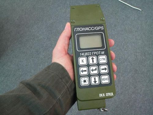
GLONASS (russian: ГЛОНАСС, label=none, ; rus, links=no, Глобальная навигационная спутниковая система, r=Global'naya Navigatsionnaya Sputnikovaya Sistema, t=Global Navigation Satellite System) is a Russian satellite navigation system operating as part of a radionavigation-satellite service. It provides an alternative to Global Positioning System (GPS) and is the second navigational system in operation with global coverage and of comparable precision. Satellite navigation devices supporting both GPS and GLONASS have more satellites available, meaning positions can be fixed more quickly and accurately, especially in built-up areas where buildings may obscure the view to some satellites. GLONASS supplementation of GPS systems also improves positioning in high latitudes (north or south). Development of GLONASS began in the Soviet Union in 1976. Beginning on 12 October 1982, numerous rocket launches added satellites to the system, ... [...More Info...] [...Related Items...] OR: [Wikipedia] [Google] [Baidu] |
Bill Clinton
William Jefferson Clinton ( né Blythe III; born August 19, 1946) is an American politician who served as the 42nd president of the United States from 1993 to 2001. He previously served as governor of Arkansas from 1979 to 1981 and again from 1983 to 1992, and as attorney general of Arkansas from 1977 to 1979. A member of the Democratic Party, Clinton became known as a New Democrat, as many of his policies reflected a centrist "Third Way" political philosophy. He is the husband of Hillary Clinton, who was a senator from New York from 2001 to 2009, secretary of state from 2009 to 2013 and the Democratic nominee for president in the 2016 presidential election. Clinton was born and raised in Arkansas and attended Georgetown University. He received a Rhodes Scholarship to study at University College, Oxford and later graduated from Yale Law School. He met Hillary Rodham at Yale; they married in 1975. After graduating from law school, Clinton returned to Arkansas ... [...More Info...] [...Related Items...] OR: [Wikipedia] [Google] [Baidu] |
Kargil War
The Kargil War, also known as the Kargil conflict, was fought between India and Pakistan from May to July 1999 in the Kargil district of Jammu and Kashmir and elsewhere along the Line of Control (LoC). In India, the conflict is also referred to as Operation Vijay ( hi, विजय, ), which was the codename of the Indian military operation in the region. The role of the Indian Air Force in acting jointly with the Indian Army was aimed at flushing out both the Pakistan Army and paramilitary troops from vacated Indian positions along the LoC,http://>.nic.in/content/op-safed-sagar in what was designated as Operation Safed Sagar ( hi, ऑपरेशन सफेद सागर, label=none, ). The conflict was triggered by the infiltration of Pakistani troops—disguised as Kashmiri militants—into strategic positions on the Indian side of the LoC, which serves as the ''de facto'' border between the two countries in the disputed region of Kashmir. During its initial sta ... [...More Info...] [...Related Items...] OR: [Wikipedia] [Google] [Baidu] |


.png)
