|
Bellingshausen Sea
The Bellingshausen Sea is an area along the west side of the Antarctic Peninsula between 57°18'W and 102°20'W, west of Alexander Island, east of Cape Flying Fish on Thurston Island, and south of Peter I Island (there the southern ''Vostokkysten''). In the south are, from west to east, Eights Coast, Bryan Coast and English Coast (west part) of West Antarctica. To the west of Cape Flying Fish it joins the Amundsen Sea. Bellingshausen Sea has an area of and reaches a maximum depth of . It contains the undersea plain Bellingshausen Plain. It takes its name from Admiral Thaddeus Bellingshausen, who explored in the area in 1821. In the late Pliocene Epoch, about 2.15 million years ago, the Eltanin asteroid (about 1-4 km in diameter) impacted at the edge of the Bellingshausen sea (at the South Pacific Ocean South is one of the cardinal directions or compass points. The direction is the opposite of north and is perpendicular to both east and west. Etymology The word ... [...More Info...] [...Related Items...] OR: [Wikipedia] [Google] [Baidu] |
Cape Flying Fish
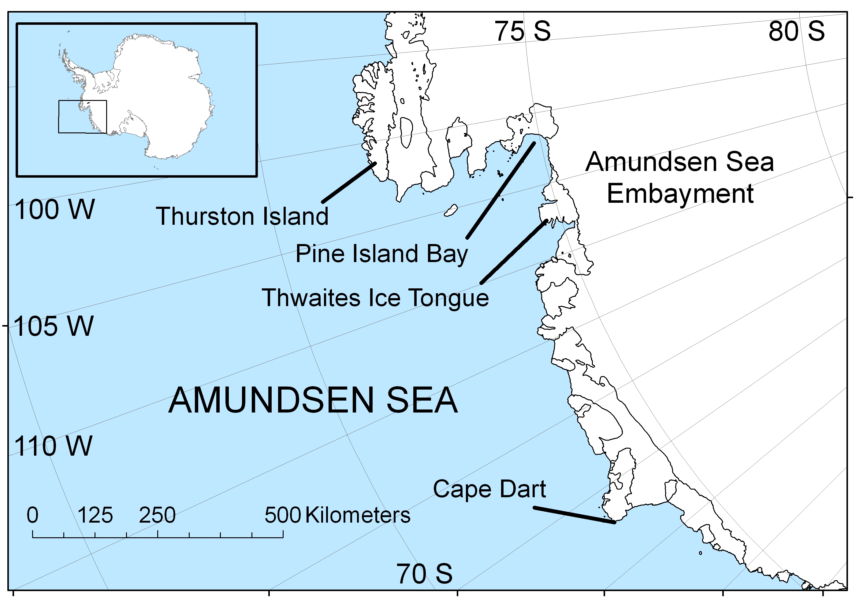
Cape Flying Fish (, also known as Cape Dart) is an ice-covered cape which forms the western extremity of Thurston Island. It was discovered by Richard E. Byrd and members of the US Antarctic Program in a flight from the USS ''Bear'' in February 1940. It was named by the Advisory Committee on Antarctic Names for the United States Exploring Expedition ship USS ''Flying Fish'', commanded by William M. Walker, which reached a point within of this cape; the ship's position on the morning of March 23, 1839, was . Cape Flying Fish separates the Amundsen Sea in the west from the Bellingshausen Sea The Bellingshausen Sea is an area along the west side of the Antarctic Peninsula between 57°18'W and 102°20'W, west of Alexander Island, east of Cape Flying Fish on Thurston Island, and south of Peter I Island (there the southern ''Vostokkys ... in the east. It constitutes the eastern boundary of the Walgreen Coast, and the western boundary of the Eights Coast. Maps Thurston ... [...More Info...] [...Related Items...] OR: [Wikipedia] [Google] [Baidu] |
Amundsen Sea
The Amundsen Sea, an arm of the Southern Ocean off Marie Byrd Land in western Antarctica, lies between Cape Flying Fish (the northwestern tip of Thurston Island) to the east and Cape Dart on Siple Island to the west. Cape Flying Fish marks the boundary between the Amundsen Sea and the Bellingshausen Sea. West of Cape Dart there is no named marginal sea of the Southern Ocean between the Amundsen and Ross Seas. The Norwegian expedition of 1928–1929 under Captain Nils Larsen named the body of water for the Norwegian polar explorer Roald Amundsen while exploring this area in February 1929. The sea is mostly ice-covered, and the Thwaites Ice Tongue protrudes into it. The ice sheet which drains into the Amundsen Sea averages about in thickness; roughly the size of the state of Texas, this area is known as the Amundsen Sea Embayment (ASE); it forms one of the three major ice-drainage basins of the West Antarctic Ice Sheet. Embayment The ice sheet which drains into the ... [...More Info...] [...Related Items...] OR: [Wikipedia] [Google] [Baidu] |
Deep Ocean
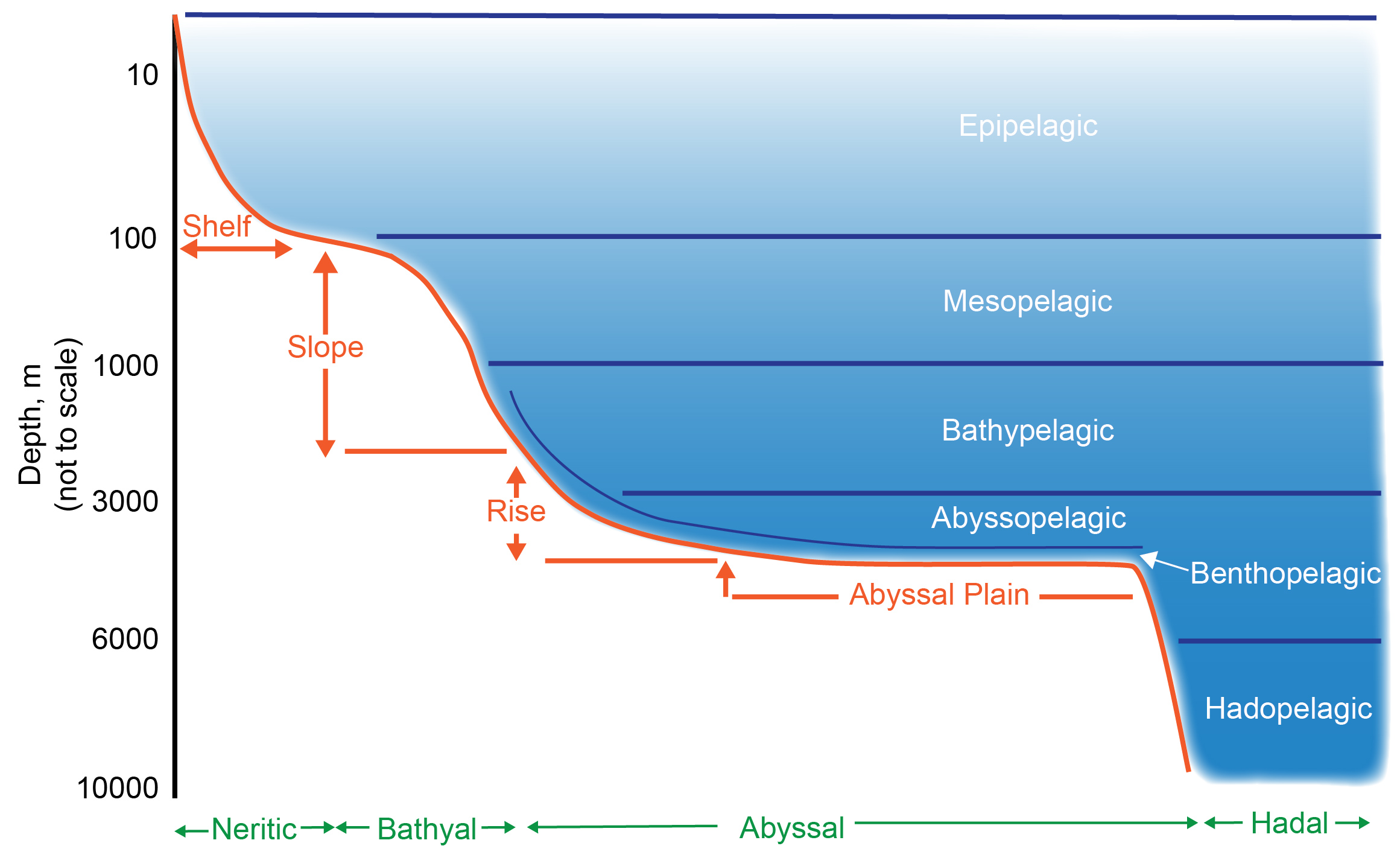
The deep sea is broadly defined as the ocean depth where light begins to fade, at an approximate depth of 200 metres (656 feet) or the point of transition from continental shelves to continental slopes. Conditions within the deep sea are a combination of low temperatures, darkness and high pressure The deep sea is considered the least explored Earth biome, with the extreme conditions making the environment difficult to access and explore. Organisms living within the deep sea have a variety of adaptations to survive in these conditions. Organisms can survive in the deep sea through a number of feeding methods including scavenging, predation and filtration, with a number of organisms surviving by feeding on marine snow. Marine snow is organic material that has fallen from upper waters into the deep sea. In 1960, the bathyscaphe ''Trieste'' descended to the bottom of the Mariana Trench near Guam, at , the deepest known spot in any ocean. If Mount Everest () were submerged there, its ... [...More Info...] [...Related Items...] OR: [Wikipedia] [Google] [Baidu] |
Pacific Ocean
The Pacific Ocean is the largest and deepest of Earth's five oceanic divisions. It extends from the Arctic Ocean in the north to the Southern Ocean (or, depending on definition, to Antarctica) in the south, and is bounded by the continents of Asia and Oceania in the west and the Americas in the east. At in area (as defined with a southern Antarctic border), this largest division of the World Ocean—and, in turn, the hydrosphere—covers about 46% of Earth's water surface and about 32% of its total surface area, larger than Earth's entire land area combined .Pacific Ocean . '' Britannica Concise.'' 2008: Encyclopædia Britannica, Inc. The centers of both the [...More Info...] [...Related Items...] OR: [Wikipedia] [Google] [Baidu] |
Eltanin Asteroid
The Eltanin impact is thought to be an asteroid impact in the eastern part of the South Pacific Ocean that occurred around the Pliocene-Pleistocene boundary approximately 2.51 ± 0.07 million years ago. The location was at the edge of the Bellingshausen Sea southwest of Chile, with a seafloor depth of approximately . The asteroid was estimated to be about in diameter. No crater associated with the impact has been discovered. The impact likely evaporated of water, generating large tsunami waves hundreds of metres high. Description The possible impact site was first discovered in 1981 as an iridium anomaly in sediment cores collected by the research vessel '' Eltanin'', after which the site and impactor are named. Later studies were done by the vessel ''Polarstern''. Sediment at the bottom of the deep ocean in the area had an iridium enrichment, a strong sign of extraterrestrial contamination. Possible debris from the asteroid is spread over an area of . Sediments fro ... [...More Info...] [...Related Items...] OR: [Wikipedia] [Google] [Baidu] |
Pliocene Epoch
The Pliocene ( ; also Pleiocene) is the epoch in the geologic time scale that extends from 5.333 million to 2.58See the 2014 version of the ICS geologic time scale million years ago. It is the second and most recent epoch of the Neogene Period in the . The Pliocene follows the Epoch and is followed by the Epoch. Prior to the 2009 ... [...More Info...] [...Related Items...] OR: [Wikipedia] [Google] [Baidu] |
Admiral Thaddeus Bellingshausen
Fabian Gottlieb Thaddeus von Bellingshausen (russian: Фадде́й Фадде́евич Беллинсга́узен, translit=Faddéy Faddéevich Bellinsgáuzen; – ) was a Russian naval officer, cartographer and explorer, who ultimately rose to the rank of admiral. He participated in the first Russian circumnavigation of the globe, and subsequently became a leader of another circumnavigation expedition that discovered the continent of Antarctica. Like Otto von Kotzebue and Adam Johann von Krusenstern, Bellingshausen belonged to the cohort of prominent Baltic German navigators who helped Russia launch its naval expeditions. Bellingshausen was born on Osel Island. He started his service in the Russian Baltic Fleet, and after distinguishing himself joined the first Russian circumnavigation of the Earth in 1803–1806, serving on the merchant ship ''Nadezhda'' under the captaincy of Adam Johann von Krusenstern. After the journey, he published a collection of maps of the ... [...More Info...] [...Related Items...] OR: [Wikipedia] [Google] [Baidu] |
Bellingshausen Plain
Bellingshausen Plain (), also known as Bellinghausen Abyssal Plain, is an undersea plain parallel to the continental rise in the Bellingshausen Sea, named for Admiral Fabian Gottlieb von Bellingshausen, commander of the Russian Antarctic Expedition (1818–1821). The name was approved by the Advisory Committee for Undersea Features The United States Board on Geographic Names (BGN) is a federal body operating under the United States Secretary of the Interior. The purpose of the board is to establish and maintain uniform usage of geographic names throughout the federal govern ... in April 1974. References * Abyssal plains of the Southern Ocean {{marine-geo-stub ... [...More Info...] [...Related Items...] OR: [Wikipedia] [Google] [Baidu] |
English Coast
English Coast is a portion of the coast of Antarctica between the northern tip of Rydberg Peninsula and the Buttress Nunataks, on the west side of Palmer Land. To the west is Bryan Coast, and northward runs Rymill Coast east of Alexander Island across George VI Sound. This coast was discovered and explored in 1940, on land by Finn Ronne and Carl R. Eklund and from the air by other members of the East Base of the US Antarctic Service (USAS), 1939–41. It was originally named "Robert English Coast" after Capt. Robert A.J. English, US Navy, Executive Secretary of USAS, 1939–41, and formerly Captain of the '' Bear of Oakland'' on the Byrd Antarctic Expedition Richard Evelyn Byrd Jr. (October 25, 1888 – March 11, 1957) was an American naval officer and explorer. He was a recipient of the Medal of Honor, the highest honor for valor given by the United States, and was a pioneering American aviator, p ..., 1933–35. The name is shortened for the sake of brevity. Referenc ... [...More Info...] [...Related Items...] OR: [Wikipedia] [Google] [Baidu] |
West Antarctica
West Antarctica, or Lesser Antarctica, one of the two major regions of Antarctica, is the part of that continent that lies within the Western Hemisphere, and includes the Antarctic Peninsula. It is separated from East Antarctica by the Transantarctic Mountains and is covered by the West Antarctic Ice Sheet. It lies between the Ross Sea (partly covered by the Ross Ice Shelf), and the Weddell Sea (largely covered by the Filchner-Ronne Ice Shelf). It may be considered a giant peninsula, stretching from the South Pole towards the tip of South America. West Antarctica is largely covered by the Antarctic ice sheet, but there have been signs that climate change is having some effect and that this ice sheet may have started to shrink slightly. Over the past 50 years, the west coast of the Antarctic Peninsula has been - and still is - one of the most rapidly warming parts of the planet, and the coasts of the Peninsula are the only parts of West Antarctica that become (in summer) ice ... [...More Info...] [...Related Items...] OR: [Wikipedia] [Google] [Baidu] |
Bellingshausen Sea Shaded And IHO Proposal
Bellingshausen may refer to: * Fabian Gottlieb von Bellingshausen (1778–1852), Baltic German explorer and officer in the Russian navy, after whom are named: ** Bellingshausen Plate, a tectonic plate ** Bellingshausen Sea, off the Antarctic Peninsula of Antarctica ** Bellingshausen Plain, an undersea plain of the Bellingshausen Sea ** Mount Bellingshausen, Antarctica ** Bellingshausen Island Bellingshausen Island is one of the most southerly of the South Sandwich Islands, close to Thule Island and Cook Island, and forming part of the Southern Thule group. It is named after its discoverer, Baltic German-Russian Antarctic explorer ... in the South Sandwich Islands ** Bellinghausen or Bellingshausen, an atoll in the Society Islands, also known as Motu One ** Bellingshausen Point, South Georgia ** Bellingshausen Station, a Russian base on King George Island, Antarctica ** 3659 Bellingshausen, an asteroid ** Bellinsgauzen (crater), a lunar crater See also * Bellinghause ... [...More Info...] [...Related Items...] OR: [Wikipedia] [Google] [Baidu] |


.jpg)


