outflow (meteorology) on:
[Wikipedia]
[Google]
[Amazon]
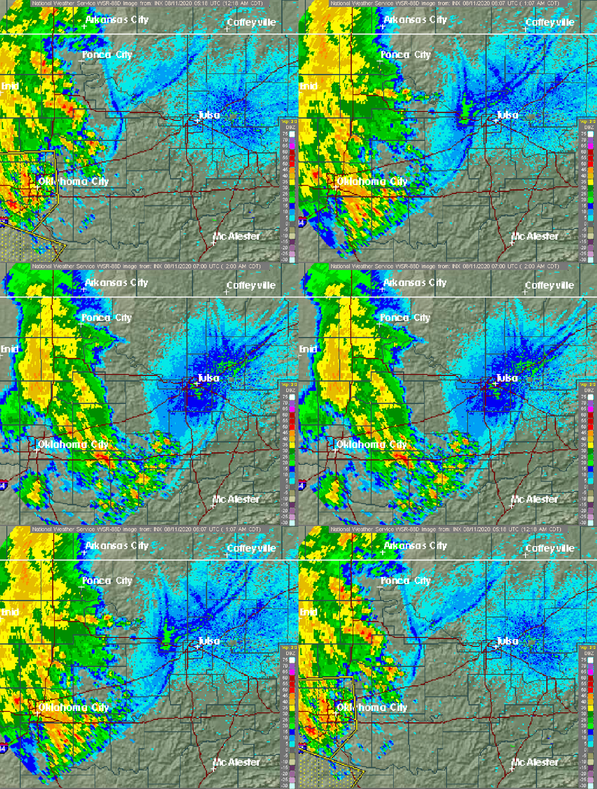 Outflow, in
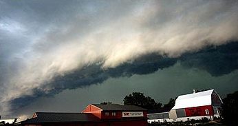 For thunderstorms, outflow tends to indicate the development of a system. Large quantities of outflow at the upper levels of a
Boundary Waters Windstorm.
 The "edge" of the
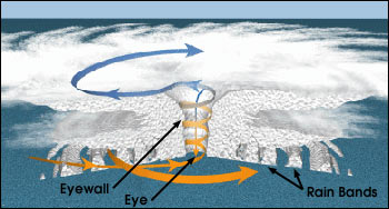 The development of a significant
 Low-level outflow boundaries from thunderstorms are cooler and more moist than the
 Outflow, in
 meteorology
Meteorology is a branch of the atmospheric sciences (which include atmospheric chemistry and physics) with a major focus on weather forecasting. The study of meteorology dates back millennia, though significant progress in meteorology did not ...
, is air that flows outwards from a storm system. It is associated with ridging, or anticyclonic
An anticyclone is a weather phenomenon defined as a large-scale circulation of winds around a central region of high atmospheric pressure, clockwise in the Northern Hemisphere and counterclockwise in the Southern Hemisphere as viewed from abov ...
flow. In the low levels of the troposphere
The troposphere is the first and lowest layer of the atmosphere of the Earth, and contains 75% of the total mass of the planetary atmosphere, 99% of the total mass of water vapour and aerosols, and is where most weather phenomena occur. From ...
, outflow radiates from thunderstorms in the form of a wedge of rain-cooled air, which is visible as a thin rope-like cloud on weather satellite
A weather satellite or meteorological satellite is a type of Earth observation satellite that is primarily used to monitor the weather and climate of the Earth. Satellites can be polar orbiting (covering the entire Earth asynchronously), or ge ...
imagery or a fine line on weather radar
Weather radar, also called weather surveillance radar (WSR) and Doppler weather radar, is a type of radar used to locate precipitation, calculate its motion, and estimate its type (rain, snow, hail etc.). Modern weather radars are mostly puls ...
imagery. For observers on the ground, a thunderstorm outflow boundary often approaches in otherwise clear skies as a low, thick cloud that brings with it a gust front
An outflow boundary, also known as a gust front, is a storm-scale or mesoscale boundary separating thunderstorm-cooled air (outflow) from the surrounding air; similar in effect to a cold front, with passage marked by a wind shift and usually a ...
.
Low-level outflow boundaries can disrupt the center of small tropical cyclone
A tropical cyclone is a rapidly rotating storm system characterized by a low-pressure center, a closed low-level atmospheric circulation, strong winds, and a spiral arrangement of thunderstorms that produce heavy rain and squalls. Depend ...
s. However, outflow aloft is essential for the strengthening of a tropical cyclone. If this outflow is restricted or undercut, the tropical cyclone weakens. If two tropical cyclones are in close proximity, the upper-level outflow from the upwind system can limit the development of the other system.
Thunderstorms
 For thunderstorms, outflow tends to indicate the development of a system. Large quantities of outflow at the upper levels of a
 thunderstorm
A thunderstorm, also known as an electrical storm or a lightning storm, is a storm characterized by the presence of lightning and its acoustic effect on the Earth's atmosphere, known as thunder. Relatively weak thunderstorms are someti ...
indicate its development. Too much outflow in the lower levels of a thunderstorm, however, can choke off the low-level inflow which fuels it. Squall line
A squall line, or more accurately a quasi-linear convective system (QLCS), is a line of thunderstorms, often forming along or ahead of a cold front. In the early 20th century, the term was used as a synonym for cold front (which often are accompa ...
s typically bow out the most, or bend the most convex outward, at the leading edge of low level outflow due to the formation of a mesoscale high-pressure area
A high-pressure area, high, or anticyclone, is an area near the surface of a planet where the atmospheric pressure is greater than the pressure in the surrounding regions. Highs are middle-scale meteorological features that result from interpl ...
which forms within the stratiform rain area behind the initial line. This high-pressure area
A high-pressure area, high, or anticyclone, is an area near the surface of a planet where the atmospheric pressure is greater than the pressure in the surrounding regions. Highs are middle-scale meteorological features that result from interpl ...
is formed due to strong descending motion behind the squall line, and could come in the form of a downburst
In meteorology, a downburst is a strong downward and outward gushing wind system that emanates from a point source above and blows radially, that is, in straight lines in all directions from the area of impact at surface level. Capable of pro ...
.Peter S. Parke and Norvan J. Larson (2005)Boundary Waters Windstorm.
National Weather Service
The National Weather Service (NWS) is an Government agency, agency of the Federal government of the United States, United States federal government that is tasked with providing weather forecasts, warnings of hazardous weather, and other weathe ...
Forecast Office, Duluth, Minnesota
, settlement_type = City
, nicknames = Twin Ports (with Superior), Zenith City
, motto =
, image_skyline =
, image_caption = Clockwise from top: urban Duluth skyline; Minnesota ...
. Retrieved on 2008-07-30.
 The "edge" of the
 outflow boundary
An outflow boundary, also known as a gust front, is a storm-scale or mesoscale boundary separating thunderstorm-cooled air (outflow) from the surrounding air; similar in effect to a cold front, with passage marked by a wind shift and usually a ...
can often be detected by Doppler radar
A Doppler radar is a specialized radar that uses the Doppler effect to produce velocity data about objects at a distance. It does this by bouncing a microwave signal off a desired target and analyzing how the object's motion has altered the f ...
(especially in clear air mode). Convergence occurs along the leading edge of the downdraft. Convergence of dust, aerosols, and bugs at the leading edge will lead to a higher clear air signature. Insect
Insects (from Latin ') are pancrustacean hexapod invertebrates of the class Insecta. They are the largest group within the arthropod phylum. Insects have a chitinous exoskeleton, a three-part body ( head, thorax and abdomen), three pairs ...
s and arthropod
Arthropods (, (gen. ποδός)) are invertebrate animals with an exoskeleton, a Segmentation (biology), segmented body, and paired jointed appendages. Arthropods form the phylum Arthropoda. They are distinguished by their jointed limbs and Arth ...
s are swept along by the prevailing winds, making them good indicators of the presence of outflow boundaries. The signature of the leading edge is also influenced by the density
Density (volumetric mass density or specific mass) is the substance's mass per unit of volume. The symbol most often used for density is ''ρ'' (the lower case Greek letter rho), although the Latin letter ''D'' can also be used. Mathematical ...
change between the cooler air from the downdraft and the warmer environmental air. This density boundary will increase the number of echo returns from the leading edge. Clouds and new thunderstorms also develop along the outflow's leading edge. This makes it possible to locate the outflow boundary when using precipitation mode on a weather radar. Also, it makes outflow boundaries findable within visible satellite imagery as a thin line of cumuliform clouds which is known as an arcus, or arc, cloud. The image to the right depicts a particularly strong outflow boundary ahead of a line of storms. Often, the outflow boundary will bow in the direction it is moving the quickest.
Tropical cyclones
 The development of a significant
 mesoscale convective complex
A mesoscale convective complex (MCC) is a unique kind of mesoscale convective system which is defined by characteristics observed in infrared satellite imagery. They are long-lived, often form nocturnally, and commonly contain heavy rainfall, wi ...
can send out a large enough outflow boundary to weaken the cyclone
In meteorology, a cyclone () is a large air mass that rotates around a strong center of low atmospheric pressure, counterclockwise in the Northern Hemisphere and clockwise in the Southern Hemisphere as viewed from above (opposite to an anti ...
as the tropical cyclone center moves into the more stable air mass
In meteorology, an air mass is a volume of air defined by its temperature and humidity. Air masses cover many hundreds or thousands of square miles, and adapt to the characteristics of the surface below them. They are classified according to la ...
behind the leading edge of thunderstorm outflow, or outflow boundary. Moderate vertical wind shear
Wind shear (or windshear), sometimes referred to as wind gradient, is a difference in wind speed and/or direction over a relatively short distance in the atmosphere. Atmospheric wind shear is normally described as either vertical or horizontal ...
can lead to the initial development of the convective complex and surface low similar to the mid-latitudes, but it must relax to allow tropical cyclogenesis
Tropical cyclogenesis is the development and strengthening of a tropical cyclone in the atmosphere. The mechanisms through which tropical cyclogenesis occurs are distinctly different from those through which temperate cyclogenesis occurs. Tr ...
to continue.
While the most obvious motion of clouds is toward the center, tropical cyclones also develop an upper-level (high-altitude) outward flow of clouds. These originate from air that has released its moisture and is expelled at high altitude through the "chimney" of the storm engine. This outflow produces high, thin cirrus cloud
Cirrus ( cloud classification symbol: Ci) is a genus of high cloud made of ice crystals. Cirrus clouds typically appear delicate and wispy with white strands. Cirrus are usually formed when warm, dry air rises, causing water vapor deposition on ...
s that spiral away from the center. The clouds are thin enough for the sun to be visible through them. These high cirrus clouds may be the first signs of an approaching tropical cyclone. As air parcels are lifted within the eye of the storm the vorticity
In continuum mechanics, vorticity is a pseudovector field that describes the local spinning motion of a continuum near some point (the tendency of something to rotate), as would be seen by an observer located at that point and traveling along wi ...
is reduced, causing the outflow from a tropical cyclone to have anticyclonic
An anticyclone is a weather phenomenon defined as a large-scale circulation of winds around a central region of high atmospheric pressure, clockwise in the Northern Hemisphere and counterclockwise in the Southern Hemisphere as viewed from abov ...
motion. If two tropical cyclones are in proximity to one another, the outflow from the system downstream (normally to the west) can hinder the development of the system upstream (normally to the east).
Local effects
 Low-level outflow boundaries from thunderstorms are cooler and more moist than the
 air mass
In meteorology, an air mass is a volume of air defined by its temperature and humidity. Air masses cover many hundreds or thousands of square miles, and adapt to the characteristics of the surface below them. They are classified according to la ...
the thunderstorm originally formed within due to its wet bulb
Wet may refer to:
* Moisture, the condition of containing liquid or being covered or saturated in liquid
* Wetting (or wetness), a measure of how well a liquid sticks to a solid rather than forming a sphere on the surface
Wet or WET may also refe ...
ing by rain
Rain is water droplets that have condensed from atmospheric water vapor and then fall under gravity. Rain is a major component of the water cycle and is responsible for depositing most of the fresh water on the Earth. It provides water f ...
, forming a wedge of denser air which spreads out from the base of the parent thunderstorm. If wind
Wind is the natural movement of air or other gases relative to a planet's surface. Winds occur on a range of scales, from thunderstorm flows lasting tens of minutes, to local breezes generated by heating of land surfaces and lasting a few hou ...
speeds are high enough, such as during microburst events, dust and sand can be carried into the troposphere
The troposphere is the first and lowest layer of the atmosphere of the Earth, and contains 75% of the total mass of the planetary atmosphere, 99% of the total mass of water vapour and aerosols, and is where most weather phenomena occur. From ...
, reducing visibility. This type of weather event is known as a haboob
A haboob ( ar, هَبوب, lit=blasting/drifting, translit=habūb) is a type of intense dust storm carried on an atmospheric gravity current, also known as a weather front. Haboobs occur regularly in dry land area regions throughout the worl ...
, and is most common in the late spring within Sudan
Sudan ( or ; ar, السودان, as-Sūdān, officially the Republic of the Sudan ( ar, جمهورية السودان, link=no, Jumhūriyyat as-Sūdān), is a country in Northeast Africa. It shares borders with the Central African Republic t ...
. Upper-level outflow can consist of thick cirrus cloud
Cirrus ( cloud classification symbol: Ci) is a genus of high cloud made of ice crystals. Cirrus clouds typically appear delicate and wispy with white strands. Cirrus are usually formed when warm, dry air rises, causing water vapor deposition on ...
s which would then obscure the sun and reduce solar insolation around the outermost edge of tropical cyclones.
References
{{good article Meteorological phenomena Severe weather and convection Synoptic meteorology and weather