Transcontinental Airway System on:
[Wikipedia]
[Google]
[Amazon]
The Transcontinental Airway System was a
 In 1923, the
 The lighted

A comprehensive map of airway beacons with downloadable beacon data
''The Survey Station''
Concrete Arrows and the U.S. Airmail Beacon System.
''Sometimes Interesting''. 04 Dec 2013
{{DEFAULTSORT:Lighted airway Air traffic control Aviation history of the United States
navigational aid
Navigation is a field of study that focuses on the process of monitoring and controlling the movement of a craft or vehicle from one place to another.Bowditch, 2003:799. The field of navigation includes four general categories: land navigation, ...
deployed in the United States
The United States of America (U.S.A. or USA), commonly known as the United States (U.S. or US) or America, is a country primarily located in North America. It consists of 50 states, a federal district, five major unincorporated territorie ...
during the 1920s.
History
 In 1923, the
 United States Congress
The United States Congress is the legislature of the federal government of the United States. It is bicameral, composed of a lower body, the House of Representatives, and an upper body, the Senate. It meets in the U.S. Capitol in Washing ...
funded a sequential lighted airway along the transcontinental airmail route. The lighted airway was proposed by National Advisory Committee for Aeronautics
The National Advisory Committee for Aeronautics (NACA) was a United States federal agency founded on March 3, 1915, to undertake, promote, and institutionalize aeronautical research. On October 1, 1958, the agency was dissolved and its assets ...
(NACA), and deployed by the Department of Commerce. It was managed by the Bureau of Standards
A standards organization, standards body, standards developing organization (SDO), or standards setting organization (SSO) is an organization whose primary function is developing, coordinating, promulgating, revising, amending, reissuing, interpr ...
Aeronautical Branch. The first segment built was between Chicago
(''City in a Garden''); I Will
, image_map =
, map_caption = Interactive Map of Chicago
, coordinates =
, coordinates_footnotes =
, subdivision_type = Country
, subdivision_name ...
and Cheyenne, Wyoming
Cheyenne ( or ) is the capital and most populous city of the U.S. state of Wyoming, as well as the county seat of Laramie County, with 65,132 residents, per the 2020 US Census. It is the principal city of the Cheyenne metropolitan statistical ...
. It was situated in the middle of the airmail route to enable aircraft to depart from either coast in the daytime, and reach the lighted airway by nightfall. Lighted emergency airfields were also funded along the route every 15–20 miles.
Construction pace was fast, and pilots wishing to become airmail pilots were first exposed to the harsh wintertime work with the crews building the first segments of the lighting system.
By the end of the year, the public anticipated anchored lighted airways across the Atlantic, Pacific, and to China.
The first nighttime airmail flights started on July 1, 1924. By eliminating the transfer of mail to rail cars at night, the coast to coast delivery time for airmail was reduced by two business days. Eventually, there were 284 beacons in service. With a June 1925 deadline, the 2,665 mile lighted airway was completed from New York to San Francisco. In 1927, the lighted airway was complete between New York City
New York, often called New York City or NYC, is the List of United States cities by population, most populous city in the United States. With a 2020 population of 8,804,190 distributed over , New York City is also the L ...
and Salt Lake City
Salt Lake City (often shortened to Salt Lake and abbreviated as SLC) is the Capital (political), capital and List of cities and towns in Utah, most populous city of Utah, United States. It is the county seat, seat of Salt Lake County, Utah, Sal ...
, Los Angeles
Los Angeles ( ; es, Los Ángeles, link=no , ), often referred to by its initials L.A., is the largest city in the state of California and the second most populous city in the United States after New York City, as well as one of the world' ...
to Las Vegas
Las Vegas (; Spanish for "The Meadows"), often known simply as Vegas, is the 25th-most populous city in the United States, the most populous city in the state of Nevada, and the county seat of Clark County. The city anchors the Las Vegas ...
, Los Angeles to San Francisco
San Francisco (; Spanish language, Spanish for "Francis of Assisi, Saint Francis"), officially the City and County of San Francisco, is the commercial, financial, and cultural center of Northern California. The city proper is the List of Ca ...
, New York to Atlanta
Atlanta ( ) is the capital and most populous city of the U.S. state of Georgia. It is the seat of Fulton County, the most populous county in Georgia, but its territory falls in both Fulton and DeKalb counties. With a population of 498,715 ...
, and Chicago
(''City in a Garden''); I Will
, image_map =
, map_caption = Interactive Map of Chicago
, coordinates =
, coordinates_footnotes =
, subdivision_type = Country
, subdivision_name ...
to Dallas
Dallas () is the List of municipalities in Texas, third largest city in Texas and the largest city in the Dallas–Fort Worth metroplex, the List of metropolitan statistical areas, fourth-largest metropolitan area in the United States at 7.5 ...
, 4121 miles in total. In 1933, the Transcontinental Airway System totaled 1500 beacons, and 18000 miles
Technical
 The lighted
 Airway Beacon
An airway beacon (US) or aerial lighthouse (UK and Europe) was a rotating light assembly mounted atop a tower. These were once used extensively in the United States for visual navigation by airplane pilots along a specified airway corridor. ...
s were a substantial navigation aid in an era prior to the development of radio navigation
Radio navigation or radionavigation is the application of radio frequencies to determine a position of an object on the Earth, either the vessel or an obstruction. Like radiolocation, it is a type of radiodetermination.
The basic principles a ...
. However, their effectiveness was limited by visibility and weather conditions.
diameter rotating beacons were mounted on high towers, and spaced ten miles apart. The spacing was closer in the mountains, and farther apart in the plains. The beacons were five million candlepower
Candlepower (abbreviated as cp or CP) is a unit of measurement for luminous intensity. It expresses levels of light intensity relative to the light emitted by a candle of specific size and constituents. The historical candlepower is equal to 0.981 ...
, and rotated six times a minute. "Ford beacons" (named after Ford
Ford commonly refers to:
* Ford Motor Company, an automobile manufacturer founded by Henry Ford
* Ford (crossing), a shallow crossing on a river
Ford may also refer to:
Ford Motor Company
* Henry Ford, founder of the Ford Motor Company
* Ford F ...
Car headlights) were also used, placing four separate lights at different angles.
Airports used green beacons and airways used red beacons. The beacons flashed identification numbers in Morse code
Morse code is a method used in telecommunication to encode text characters as standardized sequences of two different signal durations, called ''dots'' and ''dashes'', or ''dits'' and ''dahs''. Morse code is named after Samuel Morse, one of ...
. The sequence was "WUVHRKDBGM", which prompted the mnemonic
A mnemonic ( ) device, or memory device, is any learning technique that aids information retention or retrieval (remembering) in the human memory for better understanding.
Mnemonics make use of elaborative encoding, retrieval cues, and imag ...
"When Undertaking Very Hard Routes Keep Directions By Good Methods". Engineers believed the variations of beacon height along hills and valleys would allow pilots to see beacons both above ground fog, and below cloud layers.
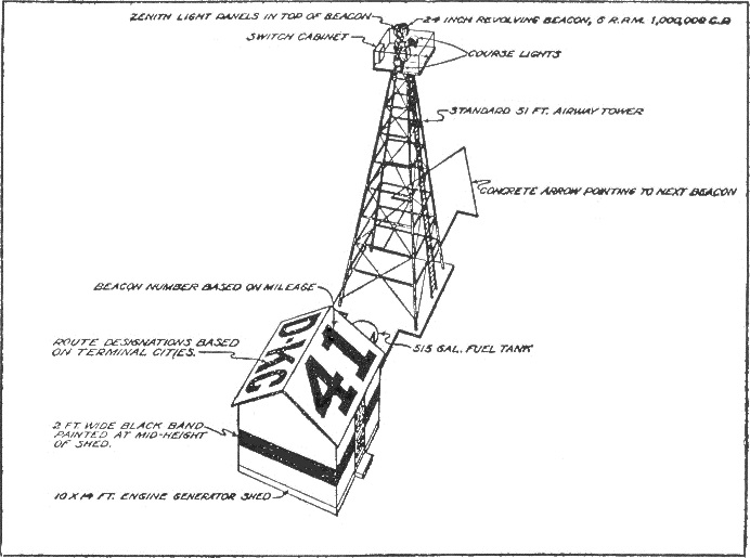
Towers were built of numbered angle iron sections with concrete footings. Some facilities used concrete arrows pointing in the direction of towers. In areas where no connection to a power grid was available, a generator was housed in a small building. Some buildings also served as weather stations. Many arrow markings were removed during World War II, to prevent aiding enemy bombers in navigation, while 19 updated beacons still remain in service in Montana.
Gallery
References
External links
A comprehensive map of airway beacons with downloadable beacon data
''The Survey Station''
Concrete Arrows and the U.S. Airmail Beacon System.
''Sometimes Interesting''. 04 Dec 2013
{{DEFAULTSORT:Lighted airway Air traffic control Aviation history of the United States