St. Patrick (provincial Electoral District) on:
[Wikipedia]
[Google]
[Amazon]
St. Patrick was a provincial

electoral district
An electoral district, also known as an election district, legislative district, voting district, constituency, riding, ward, division, or (election) precinct is a subdivision of a larger state (a country, administrative region, or other polity ...
in Ontario
Ontario ( ; ) is one of the thirteen provinces and territories of Canada.Ontario is located in the geographic eastern half of Canada, but it has historically and politically been considered to be part of Central Canada. Located in Central Ca ...
, Canada
Canada is a country in North America. Its ten provinces and three territories extend from the Atlantic Ocean to the Pacific Ocean and northward into the Arctic Ocean, covering over , making it the world's second-largest country by tot ...
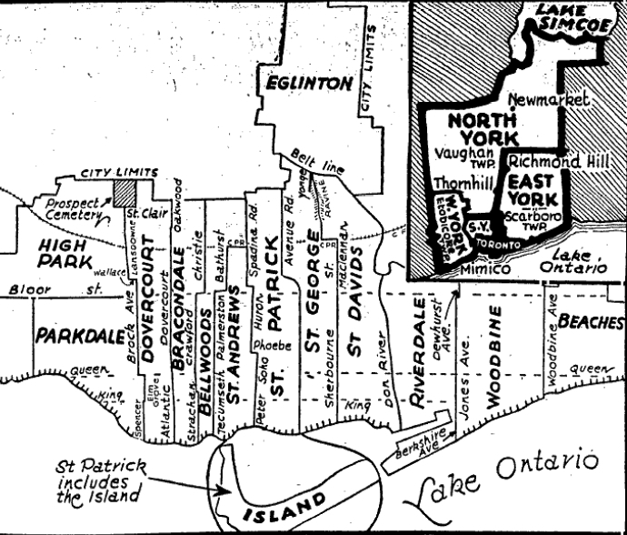
, that was established in 1926 out of the district of Toronto Northeast. It lasted until 1967 when it was merged with St. Andrew
Andrew the Apostle ( grc-koi, Ἀνδρέᾱς, Andréās ; la, Andrēās ; , syc, ܐܰܢܕ݁ܪܶܐܘܳܣ, ʾAnd’reʾwās), also called Saint Andrew, was an apostle of Jesus according to the New Testament. He is the brother of Simon Peter ...
to form St. Andrew—St. Patrick.
St. Patrick riding took its name from the former "St. Patrick's ward" of the City of Toronto.
Boundaries
It was created after a major riding redistribution in 1926. Its boundaries consisted ofSpadina Avenue
Spadina Avenue (, less commonly ) is one of the most prominent streets in Toronto, Ontario, Canada. Running through the western section of downtown, the road has a very different character in different neighbourhoods.
Spadina Avenue runs south ...
on the west from Toronto Harbour
Toronto Harbour or Toronto Bay is a bay on the north shore of Lake Ontario, in Toronto, Ontario, Canada. It is a natural harbour, protected from Lake Ontario waves by the Toronto Islands. Today, the harbour is used primarily for recreational b ...
north to the city limits just north of St. Clair Avenue. On the east the boundary followed Simcoe Street north from the harbour to Queen Street West. After a short jog east to University Avenue it followed that street north through Queen's Park Crescent and then continued north on Avenue Road through to the city limits just north of St. Clair Avenue West.
Members of Provincial Parliament
Election results
1926 boundaries
1934 boundaries

References
Notes
Citations
{{DEFAULTSORT:St. Patrick (provincial electoral district) Former provincial electoral districts of Ontario Provincial electoral districts of Toronto