South Bass Trail on:
[Wikipedia]
[Google]
[Amazon]
The South Bass Trail is a hiking trail located on the South Rim of the

Grand Canyon National Park, Official site
{{Authority control Hiking trails in Grand Canyon National Park Grand Canyon, South Rim
Grand Canyon National Park
Grand Canyon National Park, located in northwestern Arizona, is the 15th site in the United States to have been named as a national park. The park's central feature is the Grand Canyon, a gorge of the Colorado River, which is often consider ...
, located in the U.S. state of Arizona.
Access
The trail is accessible by use ofU.S. Forest Service
The United States Forest Service (USFS) is an agency of the U.S. Department of Agriculture that administers the nation's 154 national forests and 20 national grasslands. The Forest Service manages of land. Major divisions of the agency in ...
roads along the south rim of Grand Canyon
The Grand Canyon (, yuf-x-yav, Wi:kaʼi:la, , Southern Paiute language: Paxa’uipi, ) is a steep-sided canyon carved by the Colorado River in Arizona, United States. The Grand Canyon is long, up to wide and attains a depth of over a m ...
. The trailhead is located in a remote area of the park's south rim and is accessible from Rowe Well Road or Forest Service Road #328. It generally takes 1½ to 2 hours to negotiate the 29 mile (47 km) trip from Grand Canyon Village, Arizona
Grand Canyon Village is a census-designated place (CDP) located on the South Rim of the Grand Canyon, in Coconino County, Arizona, United States. Its population was 2,004 at the 2010 Census. Located in Grand Canyon National Park, it is wholly ...
. The road passes through the Havasupai Indian Reservation
An Indian reservation is an area of land held and governed by a federally recognized Native American tribal nation whose government is accountable to the United States Bureau of Indian Affairs and not to the state government in which it ...
, whose government may collect tolls to pass through. Directions are available from the park's Backcountry Information Center. The trail begins at elevation. It ends at Pasture Wash Road, Forest Service Road #2515.
Description
TheTonto Trail
The Tonto Trail is a hiking trail on the South Rim of the Grand Canyon in Grand Canyon National Park, located in the U.S. state of Arizona.
Access
The Tonto Trail does not terminate at either rim of the Grand Canyon, but begins along the south ...
crosses the South Bass Trail a mile from the Colorado River. From this junction, to the west is Elves Chasm and the terminus of the Royal Arch Route
The Royal Arch Route is a hiking trail on the South Rim of the Grand Canyon National Park, located in the U.S. state of Arizona.
Image:Royal Arch Route.jpg, A side canyon/drainage where part of the Royal Arch Route is located.
Image:Royal Arch ...
, and to the east is the Boucher Trail
The Boucher Trail is a hiking trail of the South Rim in Grand Canyon National Park, located in the U.S. state of Arizona.
Access and description
The trail officially begins at a low point on the Dripping Springs Trail, in the southwest part of He ...
and Hermit Trail, which provide access to the south rim via Hermit's Rest
Hermits Rest is a structure built in 1914 at the western end of Hermit Road at the south rim of the Grand Canyon in Arizona, United States. The Hermit Trail, a hiking trail that extends to the Colorado River, begins about ¼ mile beyond the shutt ...
.
The trail itself is considered difficult. No services are available, and the only reliable water is at the Colorado River, which must be treated before consuming.
History
At one time, this trail was connected to theNorth Bass Trail
The North Bass Trail is a hiking trail located on the North Rim of the Grand Canyon, in Grand Canyon National Park, located in the U.S. state of Arizona.
Access
The trail is accessible by use of U.S. Forest Service roads along the north rim o ...
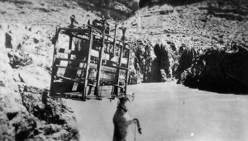
via a cable and platform that crossed the Colorado River. The tramway no longer exists, and river crossing can only be made by raft.

See also
* The Grand Canyon *List of trails in Grand Canyon National Park
The following is a list of hiking trails that are, in whole or part, within the established boundaries of Grand Canyon National Park, located in Coconino and Mohave counties in the U.S. state of Arizona.
Management
All pack and foot trails i ...
References
External links
Grand Canyon National Park, Official site
{{Authority control Hiking trails in Grand Canyon National Park Grand Canyon, South Rim