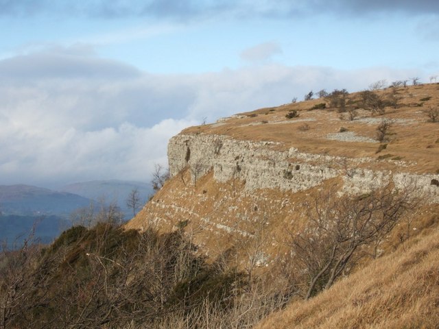
Scout Scar on:
[Wikipedia]
[Google]
[Amazon]

 Scout Scar, also called Underbarrow Scar, is a hill in the English

 Scout Scar, also called Underbarrow Scar, is a hill in the English
 Lake District
The Lake District, also known as the Lakes or Lakeland, is a mountainous region in North West England. A popular holiday destination, it is famous for its lakes, forests, and mountains (or ''fells''), and its associations with William Wordswor ...
, west of Kendal
Kendal, once Kirkby in Kendal or Kirkby Kendal, is a market town and civil parish in the South Lakeland district of Cumbria, England, south-east of Windermere and north of Lancaster. Historically in Westmorland, it lies within the dale of th ...
, Cumbria
Cumbria ( ) is a ceremonial and non-metropolitan county in North West England, bordering Scotland. The county and Cumbria County Council, its local government, came into existence in 1974 after the passage of the Local Government Act 1972. Cumb ...
and above the village of Underbarrow
Underbarrow is a small village in Cumbria, England, located west of Kendal. The village is in the Lake District National Park. It is in the civil parish of Underbarrow and Bradleyfield, in South Lakeland district, and has a parish councils in E ...
. It reaches . Scout Scar is the subject of a chapter of Wainwright's book ''The Outlying Fells of Lakeland
''The Outlying Fells of Lakeland'' is a 1974 book written by Alfred Wainwright dealing with hills in and around the Lake District of England. It differs from Wainwright's '' Pictorial Guides'' in that each of its 56 chapters describes a walk, ...
'', but the summit he describes is a lower summit at , 270m south of the highest point. Wainwright's anticlockwise recommended route also includes Cunswick Scar at . The higher summit of Scout Scar has a topographic prominence
In topography, prominence (also referred to as autonomous height, relative height, and shoulder drop in US English, and drop or relative height in British English) measures the height of a mountain or hill's summit relative to the lowest contou ...
of 109m and is thus classified as a HuMP
The mountains and hills of the British Isles are categorised into various lists based on different combinations of elevation, prominence, and other criteria such as isolation. These lists are used for peak bagging, whereby hillwalkers attempt ...
, a hill with a prominence of at least 100m.
Scout Scar and Cunswick Scar are both formed of Carboniferous Limestone
Carboniferous Limestone is a collective term for the succession of limestones occurring widely throughout Great Britain and Ireland that were deposited during the Dinantian Epoch of the Carboniferous Period. These rocks formed between 363 and ...
and dip gently towards the east with a steep western scarp slope.
At the lower, southern, summit there is a shelter, locally known as "The Mushroom". It was built in 1912 as a memorial to King George V
George V (George Frederick Ernest Albert; 3 June 1865 – 20 January 1936) was King of the United Kingdom and the British Dominions, and Emperor of India, from 6 May 1910 until his death in 1936.
Born during the reign of his grandmother Que ...
, and restored in 1969 and again in 2003. The structure includes a toposcope
A toposcope, topograph, or orientation table is a kind of graphic display erected at viewing points on hills, mountains or other high places which indicates the direction, and usually the distance, to notable landscape features which can be seen f ...
indicating the Central Fells
The Central Fells are a group of hills in the English Lake District. Reaching their highest point at High Raise (2,500 ft or 762 metres), they occupy a broad area to the east of Borrowdale. The Central Fells are generally lower than the ...
and other landmarks.
Accessible route
There is a car park in an old limestone quarry not far from the summit of Scout Scar. TheLake District National Park Authority
The Lake District National Park is a national park in North West England that includes all of the central Lake District, though the town of Kendal, some coastal areas, and the Lakeland Peninsulas are outside the park boundary.
The area was ...
includes a walk on Scout Scar in its "Miles without stiles" project for accessible routes, and describes it as "A short, steep walk to one of the best views across the entire southern lakes". This route, accessible for "robust pushchairs", leads from the car park to a viewpoint below the top of the scar.
Protection
Scout and Cunswick Scars have been designated aSite of Special Scientific Interest
A Site of Special Scientific Interest (SSSI) in Great Britain or an Area of Special Scientific Interest (ASSI) in the Isle of Man and Northern Ireland is a conservation designation denoting a protected area in the United Kingdom and Isle of ...
for their flora and fauna. In 2005 they were included in a multi-site Special Area of Conservation
A Special Area of Conservation (SAC) is defined in the European Union's Habitats Directive (92/43/EEC), also known as the ''Directive on the Conservation of Natural Habitats and of Wild Fauna and Flora''. They are to protect the 220 habitats and ap ...
, Morecambe Bay Pavements
Morecambe Bay Pavements is a multi-site Special Area of Conservation comprising limestone pavements around Morecambe Bay in North-West England. It was designated in 2005 under the Habitats Directive. The SAC does not include any marine areas; Mo ...
, which includes other limestone outcrops in Cumbria and Lancashire.
References
External links
* Fells of the Lake District Mountains and hills of the United Kingdom with toposcopes Sites of Special Scientific Interest in Cumbria {{Cumbria-geo-stub