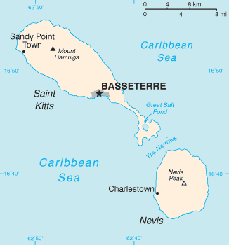
Sandy Point Town on:
[Wikipedia]
[Google]
[Amazon]
 Sandy Point is the second largest town in the island of
 Sandy Point is the second largest town in the island of
 Saint Kitts
Saint Kitts, officially the Saint Christopher Island, is an island in the West Indies. The west side of the island borders the Caribbean Sea, and the eastern coast faces the Atlantic Ocean. Saint Kitts and the neighbouring island of Nevis cons ...
, Saint Kitts and Nevis
Saint Kitts and Nevis (), officially the Federation of Saint Christopher and Nevis, is an island country and microstate consisting of the two islands of Saint Kitts and Nevis, both located in the West Indies, in the Leeward Islands chain of ...
. This town is situated on the north-west coast of St.Kitts and is the capital of Saint Anne Sandy Point Parish
Saint Anne Sandy Point is one of 14 administrative parishes that make up Saint Kitts and Nevis. It is the smallest parish on St. Kitts in terms of area, at just . It is located on the main island of Saint Kitts and the parish capital is Sandy Po ...
.
It is strongly believed that the area known as Sandy Point was the original landing point for the English sea captain and explorer, Sir Thomas Warner, in 1623. After being founded in the 1620s, the town became the commercial centre of St. Kitts and was one of the busiest ports in the region, as evidenced by the remains of the many former Dutch warehouses lining the shoreline, which once totalled over 300.
After 1727, when the bulk of commercial activity was moved to Basseterre, the town and its port slowly diminished in importance. In 1984, the port was closed entirely following the impact of Hurricane Klaus The name Klaus has been used for two tropical cyclones and one extratropical cyclone worldwide.
Tropical cyclones
In the Atlantic Ocean:
* Hurricane Klaus (1984)
Hurricane Klaus was a North Atlantic hurricane that hit the Leeward Islands fr ...
. Sandy Point has a population of 3,140.
The greatest evidence of the town's former wealth can be seen in Brimstone Hill Fortress National Park
Brimstone Hill Fortress National Park is a UNESCO World Heritage Site, a well-preserved fortress on a hill on the island of St. Kitts in the Federation of St. Christopher (St. Kitts) and Nevis in the Eastern Caribbean. It was designed by Briti ...
, a UNESCO World Heritage Site
A World Heritage Site is a landmark or area with legal protection by an international convention administered by the United Nations Educational, Scientific and Cultural Organization (UNESCO). World Heritage Sites are designated by UNESCO for h ...
. The largest fortress ever built in the Eastern Caribbean by the British, this fortress was constructed to defend the town's port and the downhill fortress of Fort Charles (Saint Kitts)
Fort Charles, also called Cleverley Point Fort, is a historic British colonial fort (est. 1670) site on the island of St. Kitts, located in the present day nation of Saint Kitts and Nevis in the Caribbean.
History
It was built on a suitable s ...
, which in turn was the colony's second largest fortification.
Today, the main industrial activity in Sandy Point Town is manufacturing aeronautics equipment. It is also a tourism centre. Nearby villages include Fig Tree, Half Way Tree and Newton Ground.
References
Populated places in Saint Kitts and Nevis Saint Kitts (island) Populated places established in 1623 1623 establishments in the British Empire 1623 establishments in North America 1620s in the Caribbean {{SaintKittsNevis-geo-stub