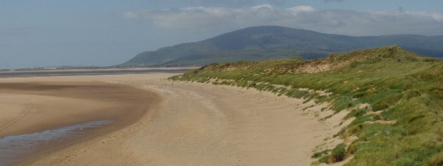
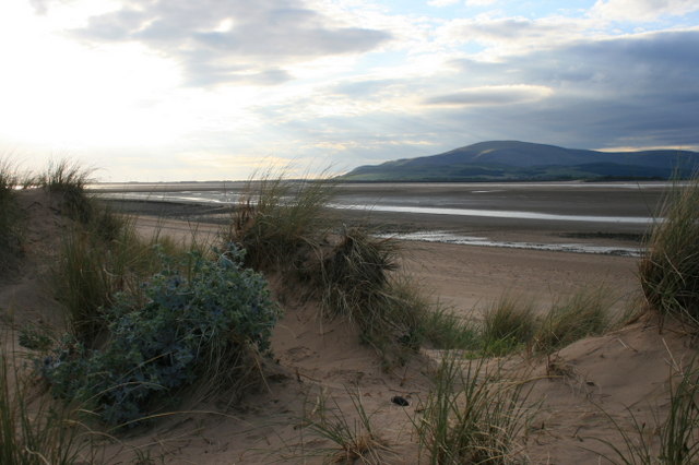
Roanhead Sands From The Dunes - Geograph on:
[Wikipedia]
[Google]
[Amazon]
 Roanhead (sometimes spelled Ronhead) refers to the limestone outcrop of Roanhead Crag in
 There are signs of shotholes on Roanhead Crag, indicating that, like Dunnerholme, it has been quarried for limestone at some time. There is a small

Environment Agency: Roan Head Bathing Water Profile
{{Coord, 54.1648, N, 3.2415, W, region:GB_source:enwiki-osgb36(TV587955), display=title Beaches of Cumbria Headlands of England Tourist attractions in Barrow-in-Furness Defunct mining companies of the United Kingdom Landforms of Cumbria
 Roanhead (sometimes spelled Ronhead) refers to the limestone outcrop of Roanhead Crag in
 Cumbria
Cumbria ( ) is a ceremonial and non-metropolitan county in North West England, bordering Scotland. The county and Cumbria County Council, its local government, came into existence in 1974 after the passage of the Local Government Act 1972. Cumb ...
and the farmland behind it, but in recent years the term has been taken to mean the sandy beaches adjoining Sandscale Haws
Sandscale Haws is a national nature reserve on the Duddon Estuary, Cumbria, England. It is managed by the National Trust. Resident species include the natterjack toad.
Industrial history
Sandscale brick and tile works appears on the 1850 Ordnan ...
extending to Snab Point.
The Irish Sea
The Irish Sea or , gv, Y Keayn Yernagh, sco, Erse Sie, gd, Muir Èireann , Ulster-Scots: ''Airish Sea'', cy, Môr Iwerddon . is an extensive body of water that separates the islands of Ireland and Great Britain. It is linked to the Ce ...
lies to the west of Roanhead, whilst the Duddon Estuary
The Duddon Estuary is the sandy, gritty estuary of the River Duddon that lies between Morecambe Bay and the North Lonsdale coast.
The River Duddon and its estuary form part of the boundary of the historic county of Lancashire.
It opens into the ...
and Walney Channel
The Walney Channel separates Walney Island from the British mainland.
The northern portion of the channel opens into the Duddon Estuary and is both narrower and shallower. The southern half of the channel is wider and is regularly dredged to allow ...
are due north and south respectively. The beach is noted for its abundance of sand dune
A dune is a landform composed of wind- or water-driven sand. It typically takes the form of a mound, ridge, or hill. An area with dunes is called a dune system or a dune complex. A large dune complex is called a dune field, while broad, f ...
s and strong, often dangerous coastal currents. Today the beach is a National Trust
The National Trust, formally the National Trust for Places of Historic Interest or Natural Beauty, is a charity and membership organisation for heritage conservation in England, Wales and Northern Ireland. In Scotland, there is a separate and ...
conservation area, and a two-mile stretch of the Cumbria Coastal Way
The Cumbria Coastal Way (CCW) is a long-distance footpath in Cumbria in northern England, following the coast from Silverdale, just over the Lancashire border, to just north of the Anglo-Scottish border. It is now part of the England Coast P ...
runs through it.
Mining
 There are signs of shotholes on Roanhead Crag, indicating that, like Dunnerholme, it has been quarried for limestone at some time. There is a small
 limekiln
A lime kiln is a kiln used for the calcination of limestone ( calcium carbonate) to produce the form of lime called quicklime (calcium oxide). The chemical equation for this reaction is
: CaCO3 + heat → CaO + CO2
This reaction can take pla ...
near the National Trust depot, one of two on the estate.
Myles Kennedy
Myles Richard Bass (born November 27, 1969), known professionally as Myles Kennedy, is an American singer, guitarist, and songwriter. He is the lead vocalist and rhythm guitarist of the rock band Alter Bridge and the lead vocalist in guitarist S ...
leased the mining rights from Thomas Sandys Thomas Sandys may refer to:
* Thomas Sandys, 2nd Baron Sandys (died 1560), English peer
* Thomas Sandys (Gatton MP) (1600–1658), English MP
* Thomas Sandys (merchant) (fl. 1682-1684), English merchant
* Thomas Sandys (Conservative politician) ...
in 1852. There may have been an earlier takenote but there is no sign of mining on the Roanhead estate on the 1850 OS map. The firm of Kennedy Brothers worked the iron mines until the last of the ore was taken from Nigel pit in July 1942 The Nigel mine alone is said to have produced 11 million tons of ore.Geology and Haematite deposits of South Cumbria, The Geological Survey of Great Britain It was one of several deposits on the estate. The farmhouse was moved to its present site shortly after the discovery of the Nigel deposit in 1902.
The mines left a series of subsidence craters which are now flooded. Along with the ponds left by Park mines, they are managed as fishing ponds by Furness Fishing Association. 

See also
*List of beaches
This is a list of beaches of the world, sorted by country. A beach is a landform along the shoreline of an ocean, sea, lake, or river. It usually consists of loose particles, which are often composed of rock, such as sand, gravel, shingle, pebb ...
References
External links
Environment Agency: Roan Head Bathing Water Profile
{{Coord, 54.1648, N, 3.2415, W, region:GB_source:enwiki-osgb36(TV587955), display=title Beaches of Cumbria Headlands of England Tourist attractions in Barrow-in-Furness Defunct mining companies of the United Kingdom Landforms of Cumbria