Plain Of Flanders on:
[Wikipedia]
[Google]
[Amazon]
300px, Western part of Plaine de Flandre, as viewed from Mount Cassel.
The Plain of Flanders (fr: ''Plaine de Flandre'' or ''plaine flamande'') is a low-lying 

plain
In geography, a plain is a flat expanse of land that generally does not change much in elevation, and is primarily treeless. Plains occur as lowlands along valleys or at the base of mountains, as coastal plains, and as plateaus or uplands ...
bordering the North Sea
The North Sea lies between Great Britain, Norway, Denmark, Germany, the Netherlands and Belgium. An epeiric sea on the European continental shelf, it connects to the Atlantic Ocean through the English Channel in the south and the Norwegian S ...
. It is part of the Low Countries
The term Low Countries, also known as the Low Lands ( nl, de Lage Landen, french: les Pays-Bas, lb, déi Niddereg Lännereien) and historically called the Netherlands ( nl, de Nederlanden), Flanders, or Belgica, is a coastal lowland region in N ...
, and the North European Plain
The North European Plain (german: Norddeutsches Tiefland – North German Plain; ; pl, Nizina Środkowoeuropejska – Central European Plain; da, Nordeuropæiske Lavland and nl, Noord-Europese Laagvlakte ; French : ''Plaine d'Europe du Nor ...
. It extends through the territories of Northern France
France (), officially the French Republic ( ), is a country primarily located in Western Europe. It also comprises of Overseas France, overseas regions and territories in the Americas and the Atlantic Ocean, Atlantic, Pacific Ocean, Pac ...
and Belgium
Belgium, ; french: Belgique ; german: Belgien officially the Kingdom of Belgium, is a country in Northwestern Europe. The country is bordered by the Netherlands to the north, Germany to the east, Luxembourg to the southeast, France to th ...
. It has two main sections : Maritime Flanders and Interior Flanders. The coastal plain consists mainly of sand dune
A dune is a landform composed of wind- or water-driven sand. It typically takes the form of a mound, ridge, or hill. An area with dunes is called a dune system or a dune complex. A large dune complex is called a dune field, while broad, fl ...
s and polder
A polder () is a low-lying tract of land that forms an artificial hydrological entity, enclosed by embankments known as dikes. The three types of polder are:
# Land reclaimed from a body of water, such as a lake or the seabed
# Flood plains s ...
s.
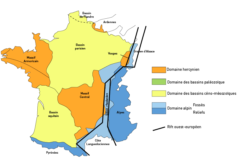
It is a feature of the Flanders Basin (fr: Bassin de Flandre), which is separated from the Parisian Basin
The Paris Basin is one of the major geological regions of France. It developed since the Triassic over remnant uplands of the Variscan orogeny (Hercynian orogeny). The sedimentary basin, no longer a single drainage basin, is a large sag in the cr ...
by the Hills of Artois
Artois ( ; ; nl, Artesië; English adjective: ''Artesian'') is a region of northern France. Its territory covers an area of about 4,000 km2 and it has a population of about one million. Its principal cities are Arras (Dutch: ''Atrecht'') ...
.
It is a formation dating the Cenozoic
The Cenozoic ( ; ) is Earth's current geological era, representing the last 66million years of Earth's history. It is characterised by the dominance of mammals, birds and flowering plants, a cooling and drying climate, and the current configura ...
era.
''Maritime Flanders'' also refers to the French Westhoek region. It refers more specifically to the Blootland (Dutch for "naked land") or the Maritime Plain (French: ''Plaine maritime'') including Dunkirk
Dunkirk (french: Dunkerque ; vls, label=French Flemish, Duunkerke; nl, Duinkerke(n) ; , ;) is a commune in the department of Nord in northern France.Bourbourg
Bourbourg (; ) is a commune in the Nord department in northern France. It is situated in the maritime plain of northern France, in the middle of a triangle formed by Dunkirk, Calais, and Saint-Omer.
Population
In 1945 Bourbourg absorbed the fo ...
, Bergues
Bergues (; nl, Sint-Winoksbergen; vls, Bergn) is a commune in the Nord department in northern France.
It is situated to the south of Dunkirk and from the Belgian border. Locally it is referred to as "the other Bruges in Flanders". Bergues ...
and Hondschoote
Hondschoote (; from Dutch; ''Hondschote'' in the modern Dutch spelling) is a commune of the Nord ''département'', in northern France.
Heraldry
Geography
Hondschoote borders Flanders, the Dutch-speaking part of Belgium. It lies 12 km f ...
.


See also
*Flanders
Flanders (, ; Dutch: ''Vlaanderen'' ) is the Flemish-speaking northern portion of Belgium and one of the communities, regions and language areas of Belgium. However, there are several overlapping definitions, including ones related to culture, ...
* Geography of Belgium
Belgium is a federal state located in Western Europe, bordering the North Sea. Belgium shares borders with France (556 km), Germany (133 km), Luxembourg (130 km) and the Netherlands (478 km). Belgium is divided into three regi ...
References
* La Flandre: étude géographique de la plaine flamande en France, Belgique et Hollande. R Blanchard, 1906 * Les changements du niveau de la mer dans la plaine maritime flamande pendant l'Holocene. R Tavernier, F Moormann, Geol. Mijnbouw, 1954 Plains of France Landforms of Flanders {{Europe-geo-stub