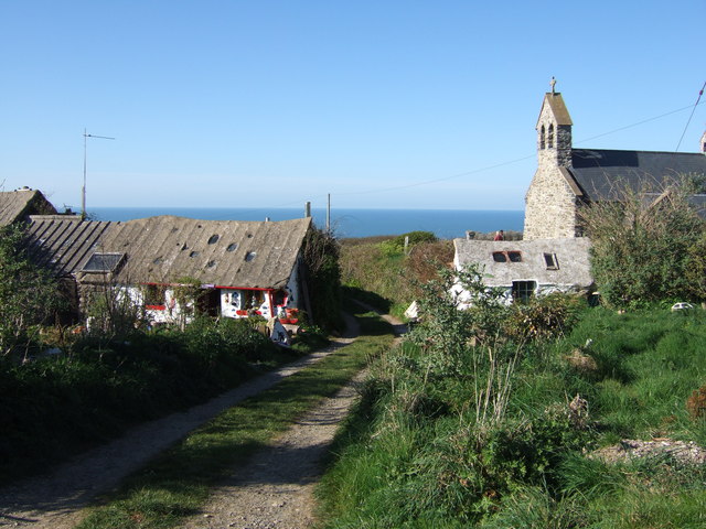
Pencaer on:
[Wikipedia]
[Google]
[Amazon]
 Pencaer is a
 Pwll Deri is on the west Pencaer coast about from
Further historical information and sources on GENUKI
{{Communities of Pembrokeshire Communities in Pembrokeshire
 Pencaer is a
 community
A community is a social unit (a group of living things) with commonality such as place, norms, religion, values, customs, or identity. Communities may share a sense of place situated in a given geographical area (e.g. a country, village, tow ...
which covers an area of dispersed settlement in Pembrokeshire
Pembrokeshire ( ; cy, Sir Benfro ) is a Local government in Wales#Principal areas, county in the South West Wales, south-west of Wales. It is bordered by Carmarthenshire to the east, Ceredigion to the northeast, and the rest by sea. The count ...
, Wales, on the peninsula of Pen Caer and comprises the village of Llanwnda and the smaller settlements of Granston
Granston ( cy, Treopert) is a hamlet and parish in Pembrokeshire, Wales. The parish was in the Hundred of Dewisland and includes the settlements of Llangloffan and Tregwynt, with Tregwynt woollen mill. Granston is in the community of Pencaer.
Na ...
, Llangloffan, St Nicholas (Tremarchog) and Trefasser. The population of the community taken at the 2011 census was 474.
Features
Rocky coastline
Strumble Head
Strumble Head ( cy, Pen Caer,Trwyn-câr, Pen Strwmbl) is a rocky headland in the community of Pencaer in Pembrokeshire, Wales, within the Pembrokeshire Coast National Park. It marks the southern limit of Cardigan Bay. Three islands lie off the ...
lies within the community, as does part of the Pembrokeshire Coast National Park
Pembrokeshire Coast National Park ( cy, Parc Cenedlaethol Arfordir Penfro) is a national park along the Pembrokeshire coast in west Wales.
It was established as a National Park in 1952. It is one of three national parks in Wales, the others bei ...
and a stretch of the Pembrokeshire Coast Path
The Pembrokeshire Coast Path ( cy, Llwybr Arfordir Sir Benfro), often called the Pembrokeshire Coastal Path, is a designated National Trail in Pembrokeshire, southwest Wales. Established in 1970, it is a long-distance walking route, mostly at ...
. Much of the community lies at above sea level, and the coastline is largely rock cliff with caves and inshore islands. There are numerous sites indicating prehistoric occupation.Ordnance Survey
Pwll Deri
 Pwll Deri is on the west Pencaer coast about from
 Goodwick
Goodwick (; cy, Wdig) is a coastal town in Pembrokeshire, Wales, immediately west of its twin town of Fishguard.
Fishguard and Goodwick form a community that wraps around Fishguard Bay. As well as the two towns, it consists of Dyffryn, Stop-and ...
( cy, Wdig) along the Pembrokeshire Coast Path
The Pembrokeshire Coast Path ( cy, Llwybr Arfordir Sir Benfro), often called the Pembrokeshire Coastal Path, is a designated National Trail in Pembrokeshire, southwest Wales. Established in 1970, it is a long-distance walking route, mostly at ...
. It sits on cliffs overlooking the bay (Pwll Deri in English is Pool of Oaks) to the west and has views of the Pembrokeshire Coast to as far away as St. David's. There is a Youth Hostel
A hostel is a form of low-cost, short-term shared sociable lodging where guests can rent a bed, usually a bunk bed in a dormitory, with shared use of a lounge and sometimes a kitchen. Rooms can be mixed or single-sex and have private or shared ba ...
at Pwll Deri and a memorial to the poet Dewi Emrys who was inspired by Pwll Deri.
Listed buildings
There are 46listed building
In the United Kingdom, a listed building or listed structure is one that has been placed on one of the four statutory lists maintained by Historic England in England, Historic Environment Scotland in Scotland, in Wales, and the Northern Irel ...
s in the community, three Grade II* and the remainder Grade II. Tregwynt Woollen Mill (Grade II) is in the southwest of the community; dating from 1819, its original purpose was to mill corn.
Economy
Livestock farming predominates, particularly sheep, and cattle for milk production, as well as some cereals and potatoes, though production of early potatoes has all but ceased.Governance
Pencaer has a community council with six elected councillors: three for Llanwnda Ward (in the north) and three for St Nicholas Ward (in the south). The latter includes Granston. There are 11 monthly meetings (August excluded).History
Prior to the abolition of parish councils in 1974, the area was governed by Llanwnda Parish Council, and the Granston and St Nicholas Parish Council; the latter's records are now held byPembrokeshire County Council
Pembrokeshire County Council ( cy, Cyngor Sir Penfro) is the governing body for Pembrokeshire, one of the Principal Areas of Wales.
Political control
The first election to the council was held in 1995, initially operating as a shadow authorit ...
. These parish councils became communities, and in 1987 the two were combined to form Pencaer community.
References
External links
Further historical information and sources on GENUKI
{{Communities of Pembrokeshire Communities in Pembrokeshire