Ojuelos de Jalisco on:
[Wikipedia]
[Google]
[Amazon]
Ojuelos de Jalisco is a colonial town and municipality in the state of

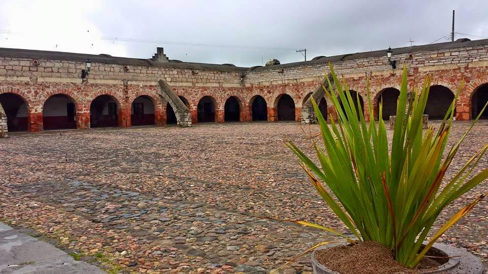
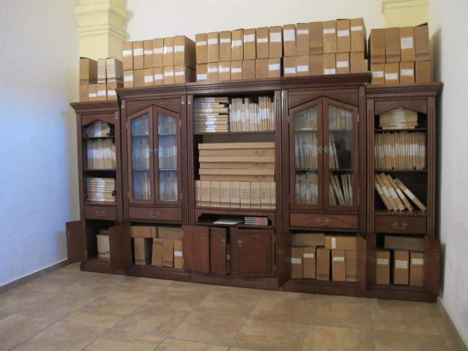
 Ojuelos has a significant value in Colonial history in Mexico and North America, since its fortification is the only one which has survived to present day keeping its main structure as originally built in 1569. Currently, it houses the offices of the City Hall and a Library.

 In 1874, Ojuelos was designated as Municipality by Ignacio L. Vallarta, Governor of the State of


 * El Fuerte (Municipal Palace). Built in the
Government Tourism
Municipality of Ojuelos
Ojuelos city
{{coord, 21, 52, N, 101, 35, W, region:MX_type:city_source:GNS-enwiki, display=title Municipalities of Jalisco 1569 establishments in New Spain Populated places established in 1569
Jalisco
Jalisco (, , ; Nahuatl: Xalixco), officially the Free and Sovereign State of Jalisco ( es, Estado Libre y Soberano de Jalisco ; Nahuatl: Tlahtohcayotl Xalixco), is one of the 31 states which, along with Mexico City, comprise the 32 Federal En ...
, Mexico
Mexico (Spanish: MĂ©xico), officially the United Mexican States, is a country in the southern portion of North America. It is bordered to the north by the United States; to the south and west by the Pacific Ocean; to the southeast by Guatema ...
. The town's 1990 population was 7,265, although by the year 2010 it had increased to 11,881.
It sits at the junction of Mexico Highways 51, 70, and 80.
The municipality is located in the North-Central region of Mexico. It is bordered by 3 states: Guanajuato
Guanajuato (), officially the Free and Sovereign State of Guanajuato ( es, Estado Libre y Soberano de Guanajuato), is one of the 32 states that make up the Federal Entities of Mexico. It is divided into 46 municipalities and its capital city i ...
, Zacatecas
, image_map = Zacatecas in Mexico (location map scheme).svg
, map_caption = State of Zacatecas within Mexico
, coordinates =
, coor_pinpoint =
, coordinates_footnotes =
, subdivision_type ...
and Aguascalientes
Aguascalientes (; ), officially the Free and Sovereign State of Aguascalientes ( es, Estado Libre y Soberano de Aguascalientes), is one of the 32 states which comprise the Political divisions of Mexico, Federal Entities of Mexico. At 22°N and ...
. Also, it is located in close proximity to the state of San Luis Potosi. All of the above makes of Ojuelos one of the municipalities with the most borders in Mexico. It also borders with the Lagos de Moreno
Lagos de Moreno () is a city and municipality in the State of Jalisco, Mexico. Lagos is located in the region of Los Altos de Jalisco, within the macroregion of the BajĂo, one of the most highly developed areas in Latin America. Lagos de Moren ...
municipality in the state of Jalisco
Jalisco (, , ; Nahuatl: Xalixco), officially the Free and Sovereign State of Jalisco ( es, Estado Libre y Soberano de Jalisco ; Nahuatl: Tlahtohcayotl Xalixco), is one of the 31 states which, along with Mexico City, comprise the 32 Federal En ...
.
History
The city was founded by Spanish conquistador Pedro Carrillo Davila in 1569, as a fortification or military garrison to protect travelers against theChichimecas
Chichimeca () is the name that the Nahua peoples of Mexico generically applied to nomadic and semi-nomadic peoples who were established in present-day Bajio region of Mexico. Chichimeca carried the meaning as the Roman term "barbarian" that des ...
warriors. The fortification of Ojuelos was one of the seven ones built at the request of the Viceroy MartĂn Enriquez de Almanza in the important route Mexico-Zacatecas which later became the Camino Real de Tierra Adentro
The Camino Real de Tierra Adentro ( en, Royal Road of the Interior Land), also known as the Silver Route, was a Spanish road between Mexico City and San Juan Pueblo (''Ohkay Owingeh''), New Mexico, USA, that was used from 1598 to 1882. It was ...
. The fortification in Ojuelos was the first being built and it is only one still in place. The decision to build the seven fortifications was made by Viceroy Enriquez de Almanza in response to deadly attacks made by Chichimecas
Chichimeca () is the name that the Nahua peoples of Mexico generically applied to nomadic and semi-nomadic peoples who were established in present-day Bajio region of Mexico. Chichimeca carried the meaning as the Roman term "barbarian" that des ...
commanded by their legendary leader Maxorro.

 Ojuelos has a significant value in Colonial history in Mexico and North America, since its fortification is the only one which has survived to present day keeping its main structure as originally built in 1569. Currently, it houses the offices of the City Hall and a Library.

 In 1874, Ojuelos was designated as Municipality by Ignacio L. Vallarta, Governor of the State of
 Jalisco
Jalisco (, , ; Nahuatl: Xalixco), officially the Free and Sovereign State of Jalisco ( es, Estado Libre y Soberano de Jalisco ; Nahuatl: Tlahtohcayotl Xalixco), is one of the 31 states which, along with Mexico City, comprise the 32 Federal En ...
, after a long border dispute with the state of Zacatecas
, image_map = Zacatecas in Mexico (location map scheme).svg
, map_caption = State of Zacatecas within Mexico
, coordinates =
, coor_pinpoint =
, coordinates_footnotes =
, subdivision_type ...
.
In 2010, Ojuelos was declared a World Heritage Site
A World Heritage Site is a landmark or area with legal protection by an international convention administered by the United Nations Educational, Scientific and Cultural Organization (UNESCO). World Heritage Sites are designated by UNESCO for h ...
by UNESCO
The United Nations Educational, Scientific and Cultural Organization is a specialized agency of the United Nations (UN) aimed at promoting world peace and security through international cooperation in education, arts, sciences and culture. It ...
as part of the Camino Real de Tierra Adentro
The Camino Real de Tierra Adentro ( en, Royal Road of the Interior Land), also known as the Silver Route, was a Spanish road between Mexico City and San Juan Pueblo (''Ohkay Owingeh''), New Mexico, USA, that was used from 1598 to 1882. It was ...
2010
File:2010 Events Collage New.png, From top left, clockwise: The 2010 Chile earthquake was one of the strongest recorded in history; The Eruption of Eyjafjallajökull in Iceland disrupts air travel in Europe; A scene from the opening ceremony of ...
.
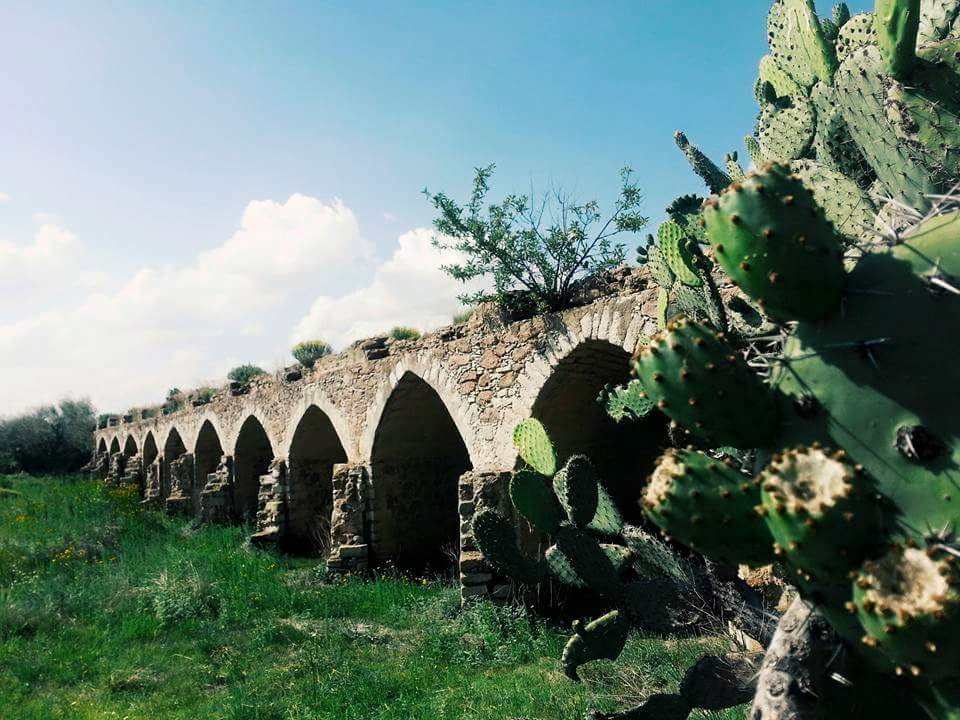
Camino Real de Tierra Adentro was the Royal Inland Road, also known as the Silver Route. This UNESCO's World Heritage Site consists of a series of sites lying along a 1400 km section of this 2600 km route, that extends north from Mexico City to Texas and New Mexico, United States of America. The route was actively used as a trade route for 300 years, from the mid-16th to the 19th centuries, mainly for transporting silver extracted from the mines of Zacatecas, Guanajuato and San Luis PotosĂ, and mercury imported from Europe. Although it is a route that was motivated and consolidated by the mining industry, it also fostered the creation of social, cultural and religious links in particular between Spanish and Amerindian cultures. In the case of Ojuelos, the specific sites inscribed in the UNESCO Roster are the historic downtown of Ojuelos (Site 1351-018) including "El Fuerte", "El Parian" and other historic buildings, and the Bridge of Ojuelos "El Puente de Ojuelos" (Site 1351-019).

Tourism
Architecture * Among other touristic attractions, Ojuelos also has a plaza, El Parián, which is surrounded by 102 Gothic arches. El Parián was designed at the end of the 19th century by priest Luis G. Maciel.

 * El Fuerte (Municipal Palace). Built in the
 16th century
The 16th century begins with the Julian year 1501 ( MDI) and ends with either the Julian or the Gregorian year 1600 ( MDC) (depending on the reckoning used; the Gregorian calendar introduced a lapse of 10 days in October 1582).
The 16th cent ...
.
* Hacienda de Ojuelos (typical hacienda house, which today is used as a training and meeting center for the parochial church).
* The Bridge of Ojuelos. Built in the 16th century
The 16th century begins with the Julian year 1501 ( MDI) and ends with either the Julian or the Gregorian year 1600 ( MDC) (depending on the reckoning used; the Gregorian calendar introduced a lapse of 10 days in October 1582).
The 16th cent ...
Churches
* Temple of San José.
Parks and reserves
* Cerro del Toro and the Mayal (Hill of the Bull and the Mayal).
* Cerro de Buenavista (Hill of Good View).
Handicrafts
* Manufacture of: wool
Wool is the textile fibre obtained from sheep and other mammals, especially goats, rabbits, and camelids. The term may also refer to inorganic materials, such as mineral wool and glass wool, that have properties similar to animal wool.
As ...
serapes
The serape or jorongo is a long blanket-like shawl/cloak, often brightly colored and fringed at the ends, worn in Mexico, especially by men. The spelling of the word sarape (or zarape) is the accepted form in Mexico and in other Spanish-spea ...
, pottery
Pottery is the process and the products of forming vessels and other objects with clay and other ceramic materials, which are fired at high temperatures to give them a hard and durable form. Major types include earthenware, stoneware and por ...
, and colonial furniture.
Treats
* Elaboration of eggnog (rompope) and prickly pear fruit sweet paste.
"Centre of Mexico"
* In the Plaza de Armas (Main Square) of Ojuelos (between the Municipal Presidency and the Parish Church of San José) there is a multicolored three-dimensional sign which reads, "OJUELOS" and below this word, in smaller white letters, the phrase "Corazón de México" (Heart of Mexico), and when searching in Google Maps the following: "Centro de México, Ojuelos", the website (or the Google Maps application) displays a satellite map with the legend: "Centro de México" and the image of a white silhouette-symbol of a photographic camera. By clicking or tapping on said camera, photographs of the main square of the town are opened, where there is a statue of a Christ with a crown of thorns, placed on a pedestal in the shape of a truncated quadrangular pyramid, and the aforementioned sign. Presumably this square is the geographic centre of the United Mexican States
Mexico (Spanish: MĂ©xico), officially the United Mexican States, is a country in the southern portion of North America. It is bordered to the north by the United States; to the south and west by the Pacific Ocean; to the southeast by Guatema ...
, which is not true.
Hoaxes of this kind have been around for decades. The townsfolk of Tequisquiapan
Tequisquiapan (; Otomi: Ntʼe) is a town and municipality located in the southeast of the state of Querétaro in central Mexico. The center of the town has cobblestone streets, traditional rustic houses with wrought iron fixtures, balconies, and w ...
, Querétaro
Querétaro (), officially the Free and Sovereign State of Querétaro ( es, Estado Libre y Soberano de Querétaro, links=no; Otomi language, Otomi: ''Hyodi Ndämxei''), is one of the Political divisions of Mexico, 32 federal entities of Mexico. I ...
, boast of having the "geographic centre" of the country, by agreement of 1916 of the first head of the Constitutionalist Army and in charge of the Federal Executive Power Venustiano Carranza
José Venustiano Carranza de la Garza (; 29 December 1859 – 21 May 1920) was a Mexican wealthy land owner and politician who was Governor of Coahuila when the constitutionally elected president Francisco I. Madero was overthrown in a February ...
. In May 1970, the municipal authorities of Tequisquiapan unveiled an allusive plaque.
The city of Aguascalientes
Aguascalientes (; ), officially the Free and Sovereign State of Aguascalientes ( es, Estado Libre y Soberano de Aguascalientes), is one of the 32 states which comprise the Political divisions of Mexico, Federal Entities of Mexico. At 22°N and ...
once also claimed to be the centre, and the authorities of that municipality placed a plaque in the Main Square of that city (no longer it is there).
For its part, the National Institute of Statistics and Geography
The National Institute of Statistics and Geography (INEGI by its name in es, Instituto Nacional de EstadĂstica, GeografĂa e Informática) is an autonomous agency of the Mexican Government dedicated to coordinate the National System of Stat ...
(INEGI, Instituto Nacional de EstadĂstica y GeografĂa) indicates that the geographic centre of Mexico, when taking into account only the continental extremes, is located at the following coordinates: , a point to the north-northwest of Nueva PastorĂa, a town located in the Zacatecan municipality Villa de Cos
Villa de Cos is one of 58 municipalities of Zacatecas, Mexico. It is located in the center-east of the state, bordered by the municipalities of Mazapil, Francisco R. Murguia, RĂo Grande, Felipe Pescador, Fresnillo, Panuco and Guadalupe in Za ...
.
But INEGI's calculation is based on averages of the means of the several longest straight lines that can be drawn between the extremes of the country.
Homero Adame MartĂnez, a researcher, traveler, and reporter of the magazine ''Mexico Desconocido'' (Unknown Mexico), calculated for the January 2000 issue of said publication, that the geographic centre of Mexico is located south of the Zacatecan town called Cañitas de Felipe Pescador, seat of the municipality of the same name, near a fork in the railroad
Rail transport (also known as train transport) is a means of transport that transfers passengers and goods on wheeled vehicles running on rails, which are incorporated in tracks. In contrast to road transport, where the vehicles run on a pre ...
Mexico City
Mexico City ( es, link=no, Ciudad de MĂ©xico, ; abbr.: CDMX; Nahuatl: ''Altepetl Mexico'') is the capital and largest city of Mexico, and the most populous city in North America. One of the world's alpha cities, it is located in the Valley o ...
-Ciudad Juárez
Ciudad Juárez ( ; ''Juarez City''. ) is the most populous city in the Mexican state of Chihuahua. It is commonly referred to as Juárez and was known as El Paso del Norte (''The Pass of the North'') until 1888. Juárez is the seat of the Juà ...
(hence, the eastern branch leads to Saltillo
Saltillo () is the capital and largest city of the northeastern Mexican state of Coahuila and is also the municipal seat of the municipality of the same name. Mexico City, Monterrey, and Saltillo are all connected by a major railroad and highwa ...
, Coahuila
Coahuila (), formally Coahuila de Zaragoza (), officially the Free and Sovereign State of Coahuila de Zaragoza ( es, Estado Libre y Soberano de Coahuila de Zaragoza), is one of the 32 states of Mexico.
Coahuila borders the Mexican states of N ...
): .
Government
Municipal presidents
References
External links
Government Tourism
Municipality of Ojuelos
Ojuelos city
{{coord, 21, 52, N, 101, 35, W, region:MX_type:city_source:GNS-enwiki, display=title Municipalities of Jalisco 1569 establishments in New Spain Populated places established in 1569