Oakwoods Metropark on:
[Wikipedia]
[Google]
[Amazon]
Oakwoods Metropark is a park in the Huron-Clinton Metroparks system, located along the 


Huron-Clinton Metroparks
Huron–Clinton Metroparks Nature centers in Michigan Protected areas of Wayne County, Michigan Huron River (Michigan) {{WayneCountyMI-geo-stub
Huron River
The Huron River is a U.S. Geological Survey. National Hydrography Dataset high-resolution flowline dataThe National Map , accessed November 7, 2011 river in southeastern Michigan, rising out of the Huron Swamp in Springfield Township in north ...
near Flat Rock, Michigan
Flat Rock is a city mostly in Wayne County of the U.S. state of Michigan. A very small portion of the city extends into Monroe County. At the 2010 census, the city population was 9,878.
History
Flat Rock began as a Wyandot settlement. It was la ...
. The park consists several miles of bike trails, numerous nature trails, horse trails, a canoe and kayak launch, and a Nature Center. It is directly connected to Willow
Willows, also called sallows and osiers, from the genus ''Salix'', comprise around 400 speciesMabberley, D.J. 1997. The Plant Book, Cambridge University Press #2: Cambridge. of typically deciduous trees and shrubs, found primarily on moist s ...
and Lower Huron Metroparks, as well as Huroc Park through a branch of the Downriver Linked Greenways.

Bike trails
Approximately 3.75 miles of bike trails run within Oakwoods Metropark in total, all of which lies within the Downriver Linked Greenways system. The main trail connects the park withWillow
Willows, also called sallows and osiers, from the genus ''Salix'', comprise around 400 speciesMabberley, D.J. 1997. The Plant Book, Cambridge University Press #2: Cambridge. of typically deciduous trees and shrubs, found primarily on moist s ...
and Lower Huron Metroparks to the north, and Huroc Park, the cities of Flat Rock and Rockwood, and Lake Erie Metropark
Lake Erie Metropark is a park in the Huron-Clinton system of metro parks. The park is a recreational facility located between the mouth of the Huron River on Lake Erie to the south and the City of Gibraltar to the north, and consists of natural ...
to the east. A short extension also connects this trail to the Nature Center and nearby nature trails within the park.
Nature trails
A number of nature trails of varying lengths can also be found near theHuron River
The Huron River is a U.S. Geological Survey. National Hydrography Dataset high-resolution flowline dataThe National Map , accessed November 7, 2011 river in southeastern Michigan, rising out of the Huron Swamp in Springfield Township in north ...
, totaling slightly under 4 miles in length. These trails primarily traverse heavily wooded areas, with portions lining the bank of the river. Additionally, a one-mile water trail
Water (chemical formula ) is an inorganic, transparent, tasteless, odorless, and nearly colorless chemical substance, which is the main constituent of Earth's hydrosphere and the fluids of all known living organisms (in which it acts as a ...
is designated along the Huron River
The Huron River is a U.S. Geological Survey. National Hydrography Dataset high-resolution flowline dataThe National Map , accessed November 7, 2011 river in southeastern Michigan, rising out of the Huron Swamp in Springfield Township in north ...
for small crafts to navigate.

Equestrian trails
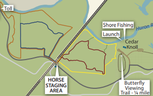
A total of 7.75 miles of equestrian trails wind through the western portion of the park, all of which are exclusively for equestrian purposes and accessible through the horse staging area. A quarter-mile butterfly viewing trail can also be found nearby.
Kayaking and canoeing
The park's only kayak and canoe launch is located behind the Nature Center on theHuron River
The Huron River is a U.S. Geological Survey. National Hydrography Dataset high-resolution flowline dataThe National Map , accessed November 7, 2011 river in southeastern Michigan, rising out of the Huron Swamp in Springfield Township in north ...
. The river connects the park with Willow
Willows, also called sallows and osiers, from the genus ''Salix'', comprise around 400 speciesMabberley, D.J. 1997. The Plant Book, Cambridge University Press #2: Cambridge. of typically deciduous trees and shrubs, found primarily on moist s ...
and Lower Huron Metroparks to the north, and Flat Rock and Lake Erie
Lake Erie ( "eerie") is the fourth largest lake by surface area of the five Great Lakes in North America and the eleventh-largest globally. It is the southernmost, shallowest, and smallest by volume of the Great Lakes and therefore also has t ...
to the south (though the Flat Rock Dam makes navigability difficult). Due to the shallow depth of the river, motorized boats are generally unable to safely traverse this portion of the Huron River
The Huron River is a U.S. Geological Survey. National Hydrography Dataset high-resolution flowline dataThe National Map , accessed November 7, 2011 river in southeastern Michigan, rising out of the Huron Swamp in Springfield Township in north ...
.
Nearby places
Oakwoods Metropark is located in Flat Rock, Michigan, and within Huron Charter Township. It lies south of nearby Detroit Metro Airport, and slightly west of downtown Flat Rock. The park is located between Sumter Township to the west and Downriver communities such as Woodhaven and Trenton to the east, with the small village of Carleton a few miles to the south. In relation to other parks in the Huron-Clinton Metroparks system, the park is slightly southeast of both Willow and Lower Huron Metroparks, and about 7 miles northwest of Lake Erie Metropark, to which Oakwoods Metropark is connected via hike/bike trail.References
External links
Huron-Clinton Metroparks
Huron–Clinton Metroparks Nature centers in Michigan Protected areas of Wayne County, Michigan Huron River (Michigan) {{WayneCountyMI-geo-stub