Nahal Harod on:
[Wikipedia]
[Google]
[Amazon]

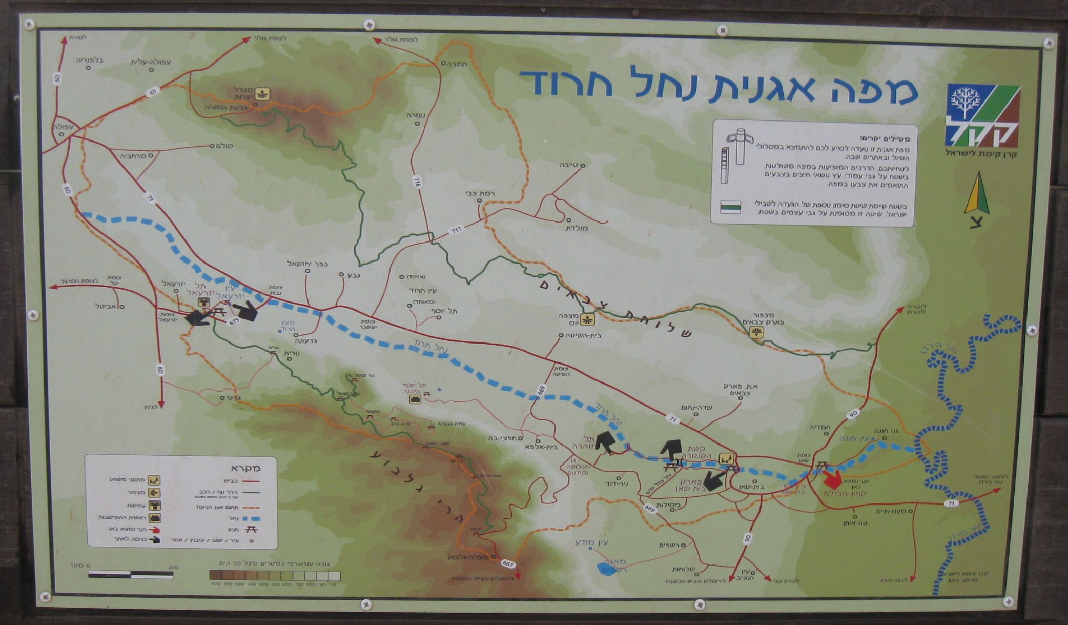
 The Harod Stream he, נחל חרוד, Nahal Harod, ar, نهر جالود, Wadi Jalud is a stream in Israel that flows west to east, from the
/ref> The elevation is above sea level at the source and below sea level at the mouth (at ). The drainage basin is .''Environmental Micropaleontology. The Application of Microfossils to Environmental Geology'', 2012
/ref> The total length from the source to mouth is , but the length of the non- intermittent flow is .جالود (نهر)
''Encyclopedia Palestina'' While the original sources of the water are karst springs,Chris Fischer
"Hydrological Modeling of the Water Resources in the Nahal Harod, Israel"
/ref> most of the stream's water comes from the discharge of numerous

 The Harod Stream he, נחל חרוד, Nahal Harod, ar, نهر جالود, Wadi Jalud is a stream in Israel that flows west to east, from the
 Givat HaMoreh
Givat HaMoreh (Hebrew: גבעת המוֹרֶה), in Arabic: Jebel ed-Duhy, is a hill in northern Israel on the northeast side of the Jezreel Valley. The highest peak reaches an altitude of , while the bottom of the Jezreel Valley is situated at ...
area via the Harod Valley
The Harod Valley ( he, עמק חרוד, Emek Harod) is a valley in the Northern District of Israel. It is the eastern part of the Jezreel Valley,a transitional zone that extends to the Beit She'an Valley. From south it locked by Mount Gilboa and ...
and Beit She'an Valley
The Beit She'an Valley ( he, בקעת בית שאן or he, עמק בית שאן) is a valley in Israel.
The valley lies within the Beit She'an rift, part of the Afro-Syrian Rift (Jordan Rift Valley), which opens westwards to the Harod Valley. I ...
into the Jordan River
The Jordan River or River Jordan ( ar, نَهْر الْأُرْدُنّ, ''Nahr al-ʾUrdunn'', he, נְהַר הַיַּרְדֵּן, ''Nəhar hayYardēn''; syc, ܢܗܪܐ ܕܝܘܪܕܢܢ ''Nahrāʾ Yurdnan''), also known as ''Nahr Al-Shariea ...
, about north of Ma'oz Haim
Maoz Haim ( he, מָעוֹז חַיִּים, ''lit.'' Haim's Fortress) is a kibbutz in Israel. Located adjacent to the Jordan River in the Beit She'an valley and falls under the jurisdiction of Valley of Springs Regional Council. In it had a ...
. It is the main drainage route of the Harod Valley"Nahal Harod Park - Archaeology & Birds of Israel"/ref> The elevation is above sea level at the source and below sea level at the mouth (at ). The drainage basin is .''Environmental Micropaleontology. The Application of Microfossils to Environmental Geology'', 2012
/ref> The total length from the source to mouth is , but the length of the non- intermittent flow is .
''Encyclopedia Palestina''
"Hydrological Modeling of the Water Resources in the Nahal Harod, Israel"
/ref> most of the stream's water comes from the discharge of numerous
fish pond
A fish pond or fishpond is a controlled pond, small artificial lake or retention basin that is stocked with fish and is used in aquaculture for fish farming, for recreational fishing, or for ornamental purposes.
Fish ponds are a classical g ...
s, irrigation systems, and sewage. Rain floods are rare, and the upper flow of the stream is dry during most of the time. The network of the stream and its tributaries is mostly man-made, and natural riverbeds are preserved at the southern steep slopes of the valley.
Places of interest
*; *Ma'ayan Harod
Ma'ayan Harod ( he, מעיין חרוד, lit=the Spring of Harod) or Ayn Jalut ( ar, عين جالوت ', lit. "the Spring of Goliath", formerly also and in Hebrew) is a spring on the southern border of the Jezreel Valley, and the location of ...
*Beit She'an
Beit She'an ( he, בֵּית שְׁאָן '), also Beth-shean, formerly Beisan ( ar, بيسان ), is a town in the Northern District (Israel), Northern District of Israel. The town lies at the Beit She'an Valley about 120 m (394 feet) below se ...
National Park
*Highway 71 (Israel)
Highway 71 is an east-west highway that passes through the eastern Jezreel Valley and the Beit She'an Valley, below the north slopes of the Gilboa mountains, in northern Israel. The road follows a path parallel to the Harod Creek in the Harod V ...

References
{{reflist Rivers of Israel