Nariva on:
[Wikipedia]
[Google]
[Amazon]
 Nariva is a
 Nariva is a
 county
A county is a geographic region of a country used for administrative or other purposesChambers Dictionary, L. Brookes (ed.), 2005, Chambers Harrap Publishers Ltd, Edinburgh in certain modern nations. The term is derived from the Old French ...
in Trinidad and Tobago
Trinidad and Tobago (, ), officially the Republic of Trinidad and Tobago, is the southernmost island country in the Caribbean. Consisting of the main islands Trinidad and Tobago, and numerous much smaller islands, it is situated south of ...
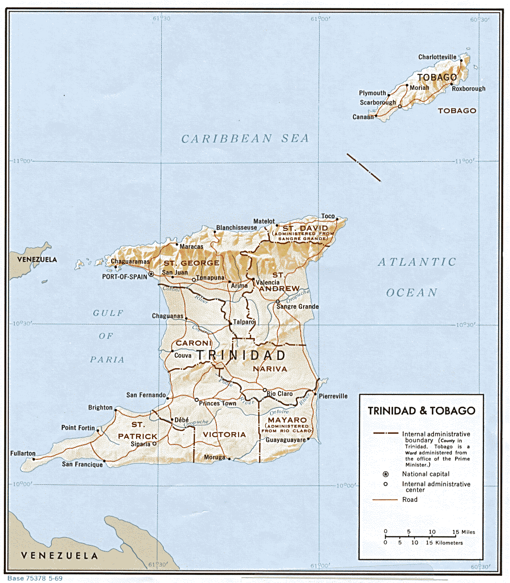
. It is located in eastern Trinidad
Trinidad is the larger and more populous of the two major islands of Trinidad and Tobago. The island lies off the northeastern coast of Venezuela and sits on the continental shelf of South America. It is often referred to as the southernmos ...
, south of Saint Andrew County
Saint Andrew is a county in Trinidad and Tobago which occupies . It is located in northeastern Trinidad, east of Saint George County, south of Saint David County and north of Nariva County. To the east it is bounded by the Atlantic Ocean. The m ...
and north of Mayaro County
Mayaro is the name of a county on southeastern Trinidad island, in Trinidad and Tobago.
History
The "Mayaro District" was the first area of settlement on the east coast. Many estates were granted to French planters who settled Trinidad in the ...
, to the west by Victoria County Victoria County is the name of several locations:
In Australia:
*Victoria County, Western Australia
* County of Victoria, South Australia
In Canada:
* Victoria County, New Brunswick
* Municipality of the County of Victoria and the eponymous histo ...
and to the northwest by Saint George County
Saint George is a county in Trinidad and Tobago. It occupies the northwestern portion of the island of Trinidad and is bounded by the Caribbean Sea to the north, the Gulf of Paria to the west, Caroni County to the south and Saint David County and ...
. The southern boundary of the county lies along the Ortoire River
The Ortoire River is a river in Trinidad and Tobago. It forms the boundary between Nariva County and Mayaro County in east Trinidad.
At over in length, it is one of Trinidad's longest rivers and is navigable by very small crafts for at least ...
and the western boundary is Cocos Bay (more commonly referred to as Manzanilla Bay). The towns of Rio Claro Rio Claro (Portuguese and Spanish for "clear river" or "clean river") may refer to:
Cities
*Rio Claro, Trinidad and Tobago, the largest town in southeastern Trinidad and Tobago
*Rio Claro, Rio de Janeiro, a Brazilian municipality in the state of R ...
and Ecclesville are located in Nariva County. The Nariva Swamp
The Nariva Swamp is the largest freshwater wetland in Trinidad and Tobago and has been designated a ''Wetland of International Importance'' under the Ramsar Convention. The swamp is located on the east coast of Trinidad, immediately inland from ...
is located in the eastern part of Nariva County.
Nariva County covers 166 km2 (64 mi2) and is divided into two wards, Charuma and Cocal. The name ''Nariva'' is of Amerindian
The Indigenous peoples of the Americas are the inhabitants of the Americas before the arrival of the European settlers in the 15th century, and the ethnic groups who now identify themselves with those peoples.
Many Indigenous peoples of the Am ...
origins.
Until 1990 Nariva was administered together with the county of Mayaro by the Nariva–Mayaro County Council. Since then the county has been split between the Sangre Grande Regional Corporation
Sangre Grande is a region of Trinidad. The Region of Sangre Grande is a local government body and the largest Region of Trinidad and Tobago by area. The region has a land area of 898.94 km². The Sangre Grande Regional Corporation is headquar ...
and the Rio Claro–Mayaro Regional Corporation.
References
* Counties of Trinidad and Tobago Rio Claro, Trinidad and Tobago Trinidad (island) Former counties {{Trinidad-geo-stub