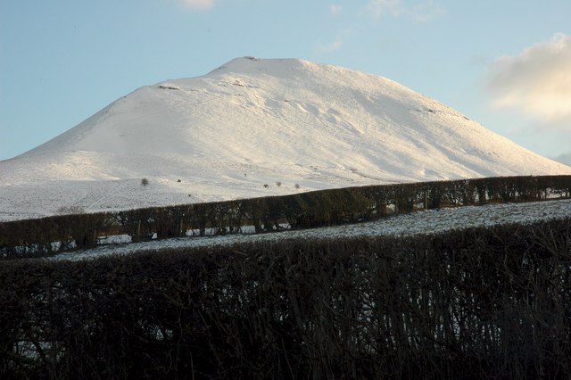
Mynydd Troed on:
[Wikipedia]
[Google]
[Amazon]
 Mynydd Troed is a hill in the Black Mountains of the
images of Mynydd Troed and surrounding area on Geograph website
{{coord, 51.9553, -3.2155, type:mountain_region:GB, display=title Black Mountains, Wales Mountains and hills of Powys Marilyns of Wales Talgarth
 Mynydd Troed is a hill in the Black Mountains of the
 Brecon Beacons National Park
The Brecon Beacons National Park ( cy, Parc Cenedlaethol Bannau Brycheiniog) is one of three national parks in Wales, and is centred on the Brecon Beacons range of hills in southern Wales. It includes the Black Mountain (range), Black Mountain ...
in Powys
Powys (; ) is a Local government in Wales#Principal areas, county and Preserved counties of Wales, preserved county in Wales. It is named after the Kingdom of Powys which was a Welsh succession of states, successor state, petty kingdom and princi ...
, south Wales
Wales ( cy, Cymru ) is a Countries of the United Kingdom, country that is part of the United Kingdom. It is bordered by England to the Wales–England border, east, the Irish Sea to the north and west, the Celtic Sea to the south west and the ...
. Its name literally translates to "Foot Mountain," based how it appears when viewed from the Allt Mawr ridge.
It lies south of Talgarth
Talgarth is a market town, community and electoral ward in southern Powys, Mid Wales, about north of Crickhowell, north-east of Brecon and south-east of Builth Wells. Notable buildings in the town include the 14th-century parish church and a ...
and northeast of the village of Llangors
Llangors (also known as Llangorse) is a small village, community and electoral ward in southern Powys, in the historic county of Brecknockshire, within the Brecon Beacons National Park.
Description
Llangors lies a few miles east of Brecon, betwe ...
on the western side of the range. Its summit at the northern end of a northwest to southeast aligned ridge reaches above sea level and is crowned by a trig point
A triangulation station, also known as a trigonometrical point, and sometimes informally as a trig, is a fixed surveying station, used in geodetic surveying and other surveying projects in its vicinity. The nomenclature varies regionally: they a ...
.
Geology
The base of the hill is formed from mudstones of the St Maughans Formation whilst the upper part is formed from the sandstones and mudstones of the Senni Beds Formation, both of which are assigned to theOld Red Sandstone
The Old Red Sandstone is an assemblage of rocks in the North Atlantic region largely of Devonian age. It extends in the east across Great Britain, Ireland and Norway, and in the west along the northeastern seaboard of North America. It also exte ...
laid down during the Devonian period
The Devonian ( ) is a geologic period and system of the Paleozoic era, spanning 60.3 million years from the end of the Silurian, million years ago (Mya), to the beginning of the Carboniferous, Mya. It is named after Devon, England, wh ...
. A few old landslide
Landslides, also known as landslips, are several forms of mass wasting that may include a wide range of ground movements, such as rockfalls, deep-seated grade (slope), slope failures, mudflows, and debris flows. Landslides occur in a variety of ...
s scar its slopes, a couple of which are seen to advantage from Castell Dinas and the ridge of Y Grib to the east. A number of small quarries have been worked on its slopes in the past.British Geological Survey 1:50,000 map sheet 214 'Talgarth' & accompanying sheet explanation
Access
Other than its lower slopes, the hill is designated as open country and therefore freely accessible to walkers. The most popular routes of ascent are from Pengenffordd on the A479 to the northeast and from the col over which the minor road up Cwm Sorgwm goes towards Llangors. Abridleway
A bridle path, also bridleway, equestrian trail, horse riding path, ride, bridle road, or horse trail, is a trail or a thoroughfare that is used by people riding horses, riding on horses. Trails originally created for use by horses often now s ...
and a restricted byway
A byway in the United Kingdom is a track, often rural, which is too minor to be called a road. These routes are often unsurfaced, typically having the appearance of ' green lanes'. Despite this, it is legal (but may not be physically possible) to ...
run around the foot of the hill to the north and west.
References
External links
images of Mynydd Troed and surrounding area on Geograph website
{{coord, 51.9553, -3.2155, type:mountain_region:GB, display=title Black Mountains, Wales Mountains and hills of Powys Marilyns of Wales Talgarth