Maybury (TV Series) on:
[Wikipedia]
[Google]
[Amazon]
 Maybury is an area on the western edge of
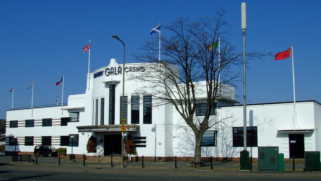
File:The Maybury - geograph.org.uk - 33048.jpg, alt=Photo of the front of the Maybury Roadhouse, Maybury Roadhouse
File:Edinburgh trams at the Maybury (geograph 3579298).jpg, Edinburgh trams at the Maybury
File:Maybury Road - geograph.org.uk - 984415.jpg, alt=image of Maybury Road, Maybury Road
 Maybury is an area on the western edge of
 Edinburgh
Edinburgh ( ; gd, Dùn Èideann ) is the capital city of Scotland and one of its 32 Council areas of Scotland, council areas. Historically part of the county of Midlothian (interchangeably Edinburghshire before 1921), it is located in Lothian ...
, Scotland
Scotland (, ) is a country that is part of the United Kingdom. Covering the northern third of the island of Great Britain, mainland Scotland has a border with England to the southeast and is otherwise surrounded by the Atlantic Ocean to the ...
, near South Gyle
South Gyle (pronounced ) is an area of Edinburgh, Scotland, lying on the western edge of the city and to the south and west of an area of former marshland once known as the Gogarloch, on the edge of Corstorphine. Most of the buildings in th ...
and Ingliston, named after the road, which is itself named after the civil engineer Sir Henry Maybury
Brigadier-General Sir Henry Percy Maybury (17 November 1864 – 7 January 1943) was a British civil engineer. He began his career as a railway engineer, working on many railways in England and Wales before becoming the county surveyor for ...
(1864–1943). In 2021, residents have been undertaking community clean ups to clear the foot paths along the road. The area is residential in the north east/east and commercial in the south and west and The Gyle Shopping Centre is nearby. In 2021, there was a consultation about creating a Primary School and Health Centre in Maybury.
Historic Buildings
Dominated by a major road junction, the most notable feature is the Maybury Roadhouse, built in 1936 and one of Edinburgh's examples ofArt Deco
Art Deco, short for the French ''Arts Décoratifs'', and sometimes just called Deco, is a style of visual arts, architecture, and product design, that first appeared in France in the 1910s (just before World War I), and flourished in the Unite ...
architecture, it was designed by Paterson and Broom. It was converted into a casino in the late 1990s. The casino has retained many art deco features within the building. It is a listed building
In the United Kingdom, a listed building or listed structure is one that has been placed on one of the four statutory lists maintained by Historic England in England, Historic Environment Scotland in Scotland, in Wales, and the Northern Irel ...
, category B. Nearby are two other listed buildings,138-140 Glasgow Road, where are traditional farm cottages, originally belonging to North Gyle Farm. The cottages were the result of the 19th century drives to the living conditions of farm workers and are Category C listed buildings. North Gyle Farm is also a Category C listed building nearby. There is a police box and Cook's Garage that were built or recorded as existing in the 1930s and that are still in the area today.
History and Archaeology
The area was farmland and the former Gogar Loch, though historical records in the 1600s describe the loch not as a standing body of water but as an area full of bogs and marshes. Archaeological excavations, between 1990 and 1992, in advance of development found a Neolithic trackway, evidence forBronze Age
The Bronze Age is a historic period, lasting approximately from 3300 BC to 1200 BC, characterized by the use of bronze, the presence of writing in some areas, and other early features of urban civilization. The Bronze Age is the second pri ...
settlement and a large stone-built structure dating to the beginning of the first millennium AD. The archaeologists believe the area was first settled in the Neolithic by farmers and that this agricultural work continued on into modern day, though probably not always continuous.
Images
References