Mawgan Porth on:
[Wikipedia]
[Google]
[Amazon]

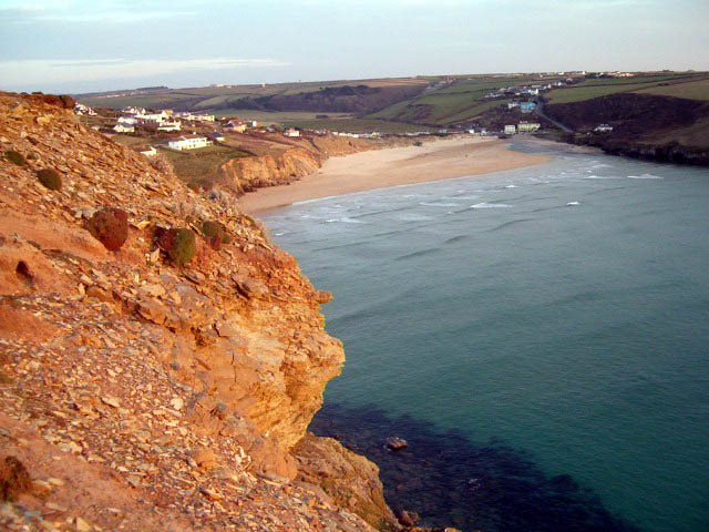
 Mawgan Porth (in kw, Porth Maugan, meaning "St. Mawgan's cove", or ''Porth Glyvyan'', meaning "cove of the Gluvian River") is a beach and small settlement in north
Abstract and download link
/ref> Mawgan Porth is recorded as ''Porthglyvyan'' in 1334, Cornish for ''cove of the little wooded valley river'', and later as ''Porthmaugan'' in 1755, Cornish for ''cove of St Mawgan''. The German sculptor Faust Lang lived in Mawgan Porth from 1936 to 1949.

 Mawgan Porth (in kw, Porth Maugan, meaning "St. Mawgan's cove", or ''Porth Glyvyan'', meaning "cove of the Gluvian River") is a beach and small settlement in north
 Cornwall
Cornwall (; kw, Kernow ) is a historic county and ceremonial county in South West England. It is recognised as one of the Celtic nations, and is the homeland of the Cornish people. Cornwall is bordered to the north and west by the Atlantic ...
, England. It is north of Watergate Bay
Watergate Bay ( kw, Porth Tregoryan, meaning ''cove at Coryan's farmstead/village'') is a long bay or beach flanked by cliffs centred two miles NNE of Newquay below the B3276 Newquay to Padstow road near the hamlet of Tregurrian in Cornwall, Uni ...
, approximately four miles (6 km) north of Newquay
Newquay ( ; kw, Tewynblustri) is a town on the north coast in Cornwall, in the south west of England. It is a civil parish, seaside resort, regional centre for aerospace industries, spaceport and a fishing port on the North Atlantic coast of ...
, on the Atlantic Ocean
The Atlantic Ocean is the second-largest of the world's five oceans, with an area of about . It covers approximately 20% of Earth's surface and about 29% of its water surface area. It is known to separate the " Old World" of Africa, Europe ...
coast.
Mawgan Porth is in the civil parish
In England, a civil parish is a type of administrative parish used for local government. It is a territorial designation which is the lowest tier of local government below districts and counties, or their combined form, the unitary authority ...
of Mawgan-in-Pydar
St Mawgan or St Mawgan in Pydar ( kw, Lanherne) is a village and civil parish in Cornwall, England, United Kingdom. The population of this parish at the 2011 census was 1,307. The village is situated four miles northeast of Newquay, and the ...
, at the seaward end of the Vale of Lanherne (or Vale of Mawgan) where the River Menalhyl meets the sea. The hamlet consists of a pub, a general store, and several hotels, guest houses and caravan parks.
The sandy beach, backed by dunes with cliffs at each end, is quality-assessed and supervised by lifeguards during the summer. It is a popular surfing
Surfing is a surface water sport in which an individual, a surfer (or two in tandem surfing), uses a board to ride on the forward section, or face, of a moving wave of water, which usually carries the surfer towards the shore. Waves suitabl ...
location. The South West Coast Path
The South West Coast Path is England's longest waymarked long-distance footpath and a National Trail. It stretches for , running from Minehead in Somerset, along the coasts of Devon and Cornwall, to Poole Harbour in Dorset. Because it rises a ...
passes behind the beach and the area attracts holiday-makers.
There are a number of local holiday parks in Mawgan Porth. The oldest is Magic Cove Touring Park; Cosy Corner is nearest to the beach, and then Sun Haven Valley Holiday Park.
History
In the years 1949–52, 1954 and 1974, archaeological excavations revealed a settlement comprising three groups of buildings ('courtyard houses') and a burial ground dating from around 850–1050. Finds included pottery and stone artefacts. Bruce-Mitford, R. ''Mawgan Porth; a settlement of the Late Saxon Period on the North Cornish Coast: Excavations 1949-52, 1954 and 1974. London: English HeritageAbstract and download link
/ref> Mawgan Porth is recorded as ''Porthglyvyan'' in 1334, Cornish for ''cove of the little wooded valley river'', and later as ''Porthmaugan'' in 1755, Cornish for ''cove of St Mawgan''. The German sculptor Faust Lang lived in Mawgan Porth from 1936 to 1949.
References
External links
{{authority control Villages in Cornwall Beaches of Cornwall Bays of Cornwall Surfing locations in Cornwall Populated coastal places in Cornwall