M-41 (Michigan Highway) on:
[Wikipedia]
[Google]
[Amazon]
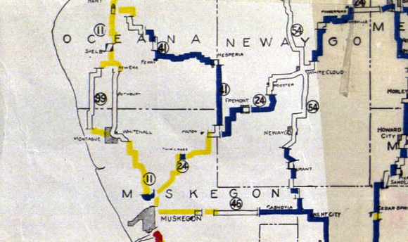
M-41 was the designation of a former state trunkline highway in the
 When the state highway system was first signed in 1919, M-41 was designated between Holton and Hart. After the creation of the
M-41
at Michigan Highways {{DEFAULTSORT:M041 041 Transportation in Muskegon County, Michigan Transportation in Newaygo County, Michigan Transportation in Oceana County, Michigan
Lower Peninsula
The Lower Peninsula of Michigan – also known as Lower Michigan – is the larger, southern and less elevated of the two major landmasses that make up the U.S. state of Michigan; the other being the Upper Peninsula, which is separated by the S ...
of the US state of Michigan
Michigan () is a state in the Great Lakes region of the upper Midwestern United States. With a population of nearly 10.12 million and an area of nearly , Michigan is the 10th-largest state by population, the 11th-largest by area, and the ...
that began near Holton and ran north- and northwest-ward, ending at Hart
Hart often refers to:
* Hart (deer)
Hart may also refer to:
Organizations
* Hart Racing Engines, a former Formula One engine manufacturer
* Hart Skis, US ski manufacturer
* Hart Stores, a Canadian chain of department stores
* Hart's Reptile W ...
. The highway was created by 1919 and lasted until 1926. The designation has not been reused since.
Route description
M-41 followed the present day route of M-120 between Holton and Hesperia. The roadway ran northeast to theMuskegon
Muskegon ( ') is a city in Michigan. It is the county seat of Muskegon County. Muskegon is known for fishing, sailing regattas, pleasure boating, and as a commercial and cruise ship port. It is a popular vacation destination because of the expan ...
–Newaygo
Newaygo ( ) is a rural city in Newaygo County in the U.S. state of Michigan. The population was 2,471 at the 2020 census.
Geography
According to the United States Census Bureau, the city has a total area of , of which is land and is water. in ...
county line. The highway turned north along the county line to the tri-point between Muskegon, Newaygo and Oceana counties. From there, M-41 followed the Oceana–Newaygo county line north to Hesperia. There it turned west to Ferry
A ferry is a ship, watercraft or amphibious vehicle used to carry passengers, and sometimes vehicles and cargo, across a body of water. A passenger ferry with many stops, such as in Venice, Italy, is sometimes called a water bus or water taxi ...
and then northwest to Hart.
History
 When the state highway system was first signed in 1919, M-41 was designated between Holton and Hart. After the creation of the
 United States Numbered Highway System
The United States Numbered Highway System (often called U.S. Routes or U.S. Highways) is an integrated network of roads and highways numbered within a nationwide grid in the contiguous United States. As the designation and numbering of these hi ...
on November 11, 1926, and the designation of U.S. Highway 41 in the Upper Peninsula
The Upper Peninsula of Michigan – also known as Upper Michigan or colloquially the U.P. – is the northern and more elevated of the two major landmasses that make up the U.S. state of Michigan; it is separated from the Lower Peninsula by t ...
, the Michigan State Highway Department
The Michigan Department of Transportation (MDOT) is a constitutional government principal department of the US state of Michigan. The primary purpose of MDOT is to maintain the Michigan State Trunkline Highway System which includes all Interstate ...
renumbered the state highways that had numbers that duplicated the then-new US Highways. In the process, the M-41 designation was decommissioned. the southern half became part of a newly designated M-20. The northern half was made part of M-82.
Major intersections
See also
*References
External links
M-41
at Michigan Highways {{DEFAULTSORT:M041 041 Transportation in Muskegon County, Michigan Transportation in Newaygo County, Michigan Transportation in Oceana County, Michigan