
Most of the counties of
England
England is a country that is part of the United Kingdom. It shares land borders with Wales to its west and Scotland to its north. The Irish Sea lies northwest and the Celtic Sea to the southwest. It is separated from continental Europe b ...
were divided into
hundred
100 or one hundred (Roman numeral: C) is the natural number following 99 and preceding 101.
In medieval contexts, it may be described as the short hundred or five score in order to differentiate the English and Germanic use of "hundred" to de ...
s or
wapentake
A hundred is an administrative division that is geographically part of a larger region. It was formerly used in England, Wales, some parts of the United States, Denmark, Southern Schleswig, Sweden, Finland, Norway, the Bishopric of Ösel–Wiek, ...
s from the late
Anglo-Saxon period and these were, with a few exceptions, effectively abandoned as administrative divisions in the 19th century.
In Wales a similar Celtic system of division called
cantrefi
A cantref ( ; ; plural cantrefi or cantrefs; also rendered as ''cantred'') was a medieval Welsh land division, particularly important in the administration of Welsh law.
Description
Land in medieval Wales was divided into ''cantrefi'', which were ...
(a hundred farmsteads) had existed for centuries and was of particular importance in the administration of the
Welsh law
Welsh law ( cy, Cyfraith Cymru) is an autonomous part of the English law system composed of legislation made by the Senedd.Law Society of England and Wales (2019)England and Wales: A World Jurisdiction of Choice eport(Link accessed: 16 March 20 ...
. Following the
Laws in Wales Acts 1535 and 1542
The Laws in Wales Acts 1535 and 1542 ( cy, Y Deddfau Cyfreithiau yng Nghymru 1535 a 1542) were Acts of the Parliament of England, and were the parliamentary measures by which Wales was annexed to the Kingdom of England. Moreover, the legal sy ...
, Wales was divided into hundreds to be consistent with England.
Bedfordshire

*Barford
*
Biggleswade
Biggleswade ( ) is a market town and civil parish in Central Bedfordshire in Bedfordshire, England. It lies on the River Ivel, 11 miles (18 km) south-east of Bedford. Its population was 16,551 in the 2011 United Kingdom census, and its e ...
*Clifton
*Flitt
*
Manshead
Manshead was a hundred of Bedfordshire in England. It covered an area in the south-west of the county stretching from Salford to Studham and from Leighton Buzzard to Houghton Regis and Dunstable.
The hundred was named after a site in Evershol ...
*Redbornestoke
*Stodden
*
Willey
*
Wixamtree
Wixamtree is an ancient hundred located in Bedfordshire, England.
Wixamtree was one of the hundreds of Bedfordshire, with its council being the primary form of local government in its area from the Anglo-Saxon times to the nineteenth century.
...
Berkshire

The County of Berkshire comprised 20 Hundreds and 193 parishes and parts of four others. From
The National Gazetteer of Britain and Ireland' (1868), ''Victoria County History Berkshire'' Vol 3 (1923) & Vol 4 (1924)
Buckinghamshire

Until at least the time of the
Domesday Survey
Domesday Book () – the Middle English spelling of "Doomsday Book" – is a manuscript record of the "Great Survey" of much of England and parts of Wales completed in 1086 by order of King William I, known as William the Conqueror. The manusc ...
in 1086 there were 18 hundreds in Buckinghamshire. It has been suggested however that neighbouring hundreds had already become more closely associated in the 11th century so that by the end of the 14th century the original or ancient hundreds had been consolidated into 8 larger hundreds.
*
Ashendon Hundred
*
Aylesbury Hundred
Aylesbury Hundred was a hundred in the ceremonial county of Buckinghamshire, England. It was situated in the centre of the county and was bounded on the east by Hertfordshire and on the west by Oxfordshire.
History
Until at least the time of the ...
– consolidated from the eleventh century Aylesbury, Risborough and Stone hundreds
*
Buckingham Hundred
Buckingham Hundred was a hundred in the ceremonial county of Buckinghamshire, England. It was situated in the north west of the county and forming the boundary with the counties of Oxfordshire and Northamptonshire. There was also a small detac ...
*
Cottesloe Hundred
*
Newport Hundred
Newport Hundred was a hundred in the county of Buckinghamshire, England. It encompassed the north of the county, enclosed by the counties of Bedfordshire and Northamptonshire and the Buckinghamshire hundreds of Aylesbury and Buckingham. It wa ...
Chiltern Hundreds
*
Burnham Hundred
*
Desborough Hundred
*
Stoke Hundred
Stoke Hundred is a hundred in Buckinghamshire, England. It is situated in the south of the county and is bounded on the east by Middlesex and on the south by Berkshire.
History
Until at least the time of the Domesday Survey in 1086 there were 1 ...
Cambridgeshire

Cambridgeshire was divided into 17 hundreds, plus the borough of
Cambridge
Cambridge ( ) is a university city and the county town in Cambridgeshire, England. It is located on the River Cam approximately north of London. As of the 2021 United Kingdom census, the population of Cambridge was 145,700. Cambridge bec ...
. Each hundred had a separate council that met each month to rule on local judicial and taxation matters. In 1929 the hundreds contained the following parishes.
Cheshire

From Harris, B. E., and Thacker, A. T. (1987). ''The Victoria History of the County of Chester. (Volume 1: Physique, Prehistory, Roman, Anglo-Saxon, and Domesday).'' Oxford: Oxford University Press. .
*
Broxton
*
Bucklow
*
Eddisbury
*
Macclesfield
Macclesfield is a market town and civil parish in the unitary authority of Cheshire East in Cheshire, England. It is located on the River Bollin in the east of the county, on the edge of the Cheshire Plain, with Macclesfield Forest to its east ...
*
Nantwich
Nantwich ( ) is a market town and civil parish in the unitary authority of Cheshire East in Cheshire, England. It has among the highest concentrations of listed buildings in England, with notably good examples of Tudor and Georgian architecture. ...
*
Northwich
*
Wirral
Cornwall
In
Cornwall
Cornwall (; kw, Kernow ) is a historic county and ceremonial county in South West England. It is recognised as one of the Celtic nations, and is the homeland of the Cornish people. Cornwall is bordered to the north and west by the Atlantic ...
, the name
calque
In linguistics, a calque () or loan translation is a word or phrase borrowed from another language by literal word-for-word or root-for-root translation. When used as a verb, "to calque" means to borrow a word or phrase from another language wh ...
d ''cantrev''

From GENUK
Genuki: Cornwall, Cornwall
*
Penwith
Penwith (; kw, Pennwydh) is an area of Cornwall, England, United Kingdom, located on the peninsula of the same name. It is also the name of a former local government district, whose council was based in Penzance. The area is named after ...
(Penwyth)
*
Kerrier (Keryer)
*
Pydar
The hundreds of Cornwall ( kw, Keverangow Kernow) were administrative divisions or Shires ( hundreds) into which Cornwall, the present day administrative county of England, in the United Kingdom, was divided between and 1894, when they were r ...
(Pedera)
*
Powder
A powder is a dry, bulk solid composed of many very fine particles that may flow freely when shaken or tilted. Powders are a special sub-class of granular materials, although the terms ''powder'' and '' granular'' are sometimes used to distin ...
(Pow Ereder)
*
Trigg (Trigor)
*
Lesnewth
__NOTOC__
Lesnewth ( kw, Lysnowyth) is a civil parish and village in Cornwall, England, United Kingdom. It is about six miles east of Tintagel Head and two miles east of Boscastle.
The parish is bounded on the north by St Juliot (where the 2011 ...
(Lysnowyth)
*
Stratton (Stradneth)
*
West
West or Occident is one of the four cardinal directions or points of the compass. It is the opposite direction from east and is the direction in which the Sunset, Sun sets on the Earth.
Etymology
The word "west" is a Germanic languages, German ...
(Fawy)
*
East
East or Orient is one of the four cardinal directions or points of the compass. It is the opposite direction from west and is the direction from which the Sun rises on the Earth.
Etymology
As in other languages, the word is formed from the fac ...
(Ryslegh)
For some purposes, the
Isles of Scilly
The Isles of Scilly (; kw, Syllan, ', or ) is an archipelago off the southwestern tip of Cornwall, England. One of the islands, St Agnes, is the most southerly point in Britain, being over further south than the most southerly point of the ...
were counted as a tenth hundred.
Cumberland
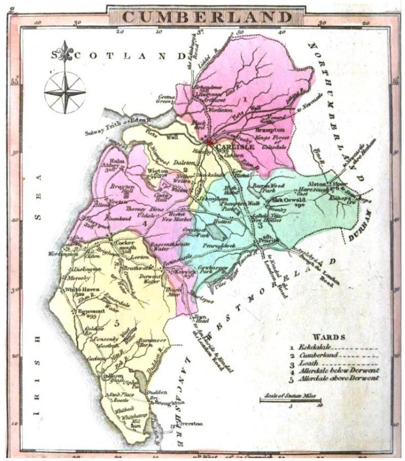 Cumberland
 was divided into wards, analogous to hundreds. From the ''National Gazetteer of Britain and Ireland'
Genuki: CUMBERLAND, England - History and Description, 1868, Cumberland
*
Allerdale-above-Derwent
*
Allerdale-below-Derwent
*
Cumberland
*
Eskdale
*
Leath
Leath was one of the wards of the historic county of Cumberland in north west England. Unlike most other English counties, Cumberland was divided into wards rather than hundreds.
The ward was bounded on the south by Westmorland, the north b ...
Derbyshire

The civil divisions of
Derbyshire
Derbyshire ( ) is a ceremonial county in the East Midlands, England. It includes much of the Peak District National Park, the southern end of the Pennine range of hills and part of the National Forest. It borders Greater Manchester to the nor ...
were anciently called wapentakes. In the Domesday Survey of 1086 are mentioned the wapentakes of Scarvedale, Hamestan, Morlestan, Walecross, and Apultre, and a district called Peche-fers.
[https://books.google.com/books?id=qUBaAAAAcAAJ&pg=PR11&dq=Morleston+Wapentake&hl=en&sa=X&ei=lAzrVPPuIcKiNrnDg6AP&ved=0CDoQ6AEwBQ#v=onepage&q=Morleston%20Wapentake&f=false Derbyshire 5, page xi.] Divided into hundreds by 1273. From GENUK
Genuki: DERBYSHIRE, England - History and Description, 1868, Derbyshire(based on the 1868 Gazette):
*
High Peak—Hamestan wapentake and perhaps Peche-fers district in 1086; Peck wapentake by 1273.
*
Wirksworth
Wirksworth is a market town in the Derbyshire Dales district of Derbyshire, England. Its population of 5,038 in the 2011 census was estimated at 5,180 in 2019. Wirksworth contains the source of the River Ecclesbourne. The town was granted a mar ...
—Called a wapentake as late as 1817.
*
Scarsdale
*
Morleston and Litchurch—Called in the Domesday Survey of 1086, Morlestan or Morleystone wapentake and Littlechurch wapentake, and in the Hundred-Roll of 1273, Littlechirch; by 1300 combined as the hundred of Morleston and Litchurch.
*
Appletree
*
Repton and Gresley—In 1274 formed the separate wapentakes of Repindon and Greselegh (owned by the King and the heirs of the Earl of Chester respectively); in 1086 the large Walecross wapentake.
Devon

In 1850 there were thirty-two hundreds in Devon according to ''
White's History, Gazetteer, and Directory of Devonshire''
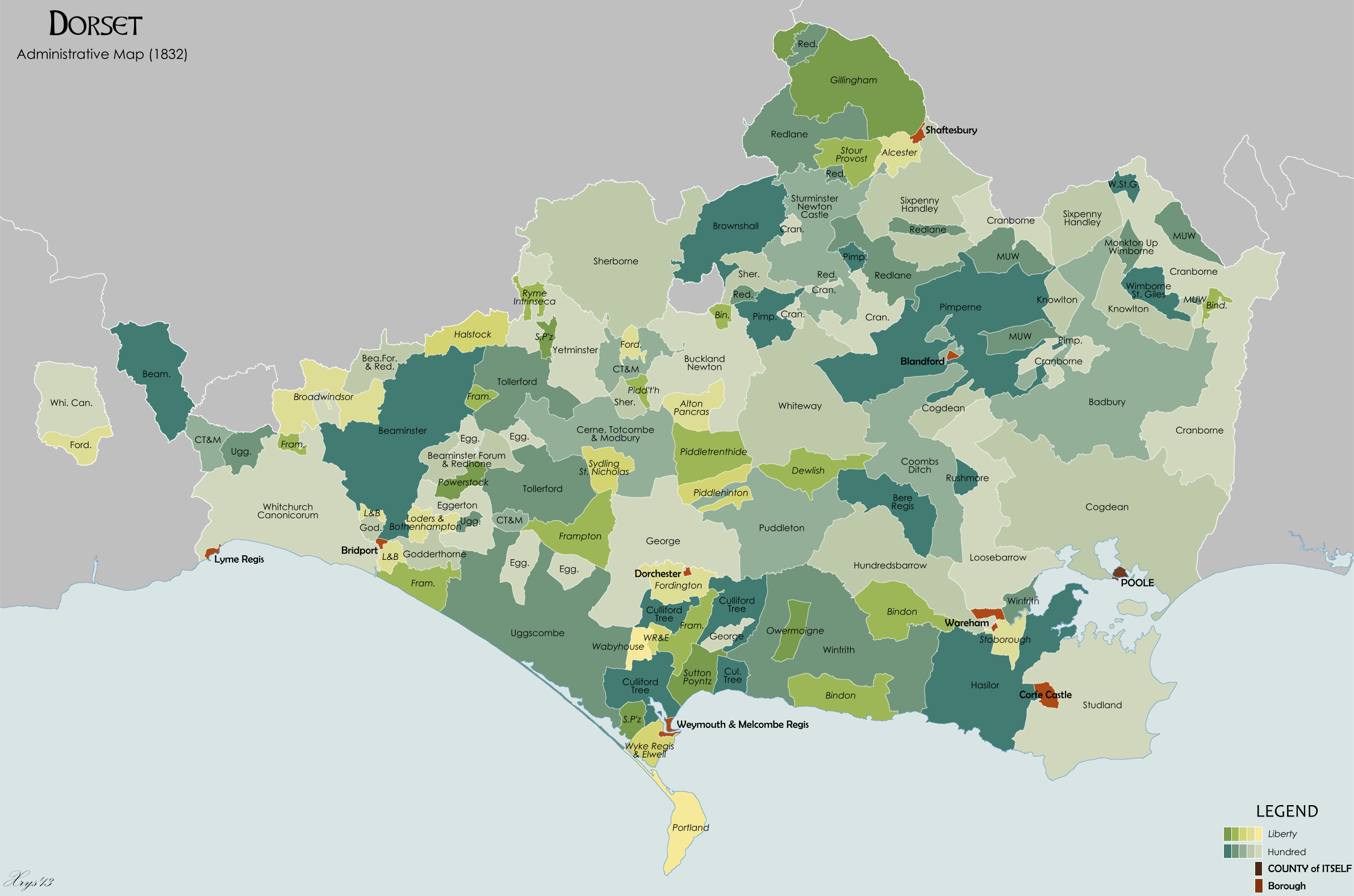
Dorset
County Durham
County Durham was divided into wards, analogous to hundreds. From an 1840 map of County Durha
Genuki: Co Durham in 1840, Durham
*
Chester-le-Street
Chester-le-Street (), also known as Chester, is a market town and civil parish in County Durham, England, around north of Durham and also close to Sunderland and Newcastle upon Tyne. It is located on the River Wear, which runs out to sea at ...
*
Sadberge
*
Easington
*
Stockton
Essex

*
Barstable (sometimes spelled Barnstable)
*
Becontree
Becontree or Both pronunciations are given as Received Pronunciation in the Longman Pronunciation Dictionary, but the form is prioritised (). The dialectologist Peter Wright wrote in 1981 that is the traditional pronunciation in the cockney ...
*
Chafford
Chafford was an ancient hundred in the south west of the county of Essex, England.Vision of Britain Chafford hundredhistoric map) Its area has been partly absorbed by the growth of London; with its name reused for the modern housing development of ...
*
Chelmsford
Chelmsford () is a City status in the United Kingdom, city in the City of Chelmsford district in the county of Essex, England. It is the county town of Essex and one of three cities in the county, along with Southend-on-Sea and Colchester. It ...
*
Clavering
*
Dengie
Dengie is a village and civil parish in the Maldon district of Essex, England, with a population of 119 at the 2011 census.
It gives its name to the Dengie peninsula and hundred and to the Dengie Special Protection Area.
The place-name 'Dengi ...
, known at the time of Domesday as Witbrictesherna (''Wibrihtesherne'') Hundred
*
Dunmow
*
Freshwell
*
Harlow
*Liberty of
Havering
The London Borough of Havering () in East London, England, forms part of Outer London. It has a population of 259,552 inhabitants; the principal town is Romford, while other communities are Hornchurch, Upminster, Collier Row and Rainham. The ...
, also sometimes known as Romford Hundred
*
Hinckford
*
Lexden
Lexden is a suburb of Colchester and former civil parish, now in the unparished area of Colchester, in the Colchester district, in the county of Essex, England. It was formerly a village, and has previously been called Lessendon, Lassendene and ...
*
Ongar
*
Rochford
*
Tendring
Tendring is a village and civil parish in Essex. It gives its name to the Tendring District and before that the Tendring Hundred. Its name was given to the larger groupings because it was at the centre, not because it was larger than the other ...
*
Thurstable
*
Uttlesford
Uttlesford is a local government district in Essex, England. Its council is based in the market town of Saffron Walden. At the 2011 Census, the population of the district was 79,443. Other notable settlements include Great Dunmow, Elmdon, S ...
*
Waltham
*
Winstree
*
Witham
Witham () is a town in the county of Essex in the East of England, with a population ( 2011 census) of 25,353. It is part of the District of Braintree and is twinned with the town of Waldbröl, Germany. Witham stands between the city of Che ...
According to essex1841.co
Hundreds in the Essex 1841 censusthe 1841 census also recorded
Harwich hundred, which the Victoria County History places within Tendring.
Gloucestershire
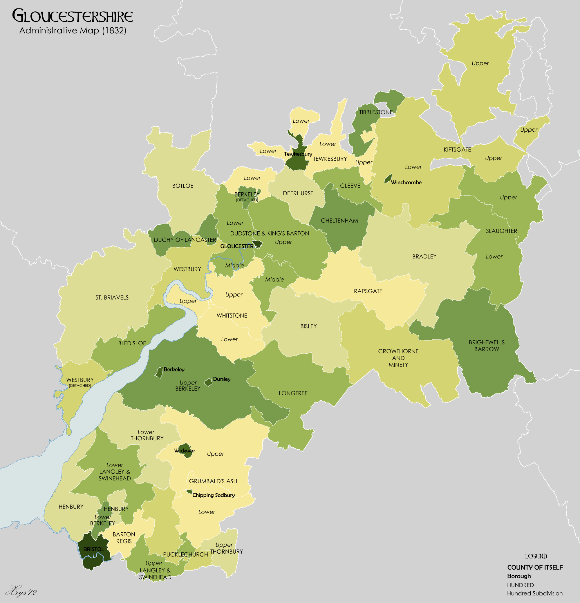
The thirty-nine hundreds mentioned in the Domesday Survey and the thirty-one hundreds of the Hundred Rolls of 1274 differ very widely in name and extent both from each other and from the twenty-eight hundreds of the present day.
From the ''National Gazetteer of Britain and Ireland'
Genuki: Miscellaneous Places, Gloucestershire, Gloucestershire*
Barton Regis
*
Berkeley
Berkeley most often refers to:
*Berkeley, California, a city in the United States
**University of California, Berkeley, a public university in Berkeley, California
* George Berkeley (1685–1753), Anglo-Irish philosopher
Berkeley may also refer ...
*
Bishop's Cleeve
Bishop's Cleeve is a large village and civil parish in the Borough of Tewkesbury in the ceremonial county of Gloucestershire, England. Cheltenham. The village lies at the foot of Cleeve Hill, the highest point in the Cotswolds. Bishop's Cleeve ...
*
Bisley
*
Bledisloe
*
Botloe
*
Bradley
Bradley is an English surname derived from a place name meaning "broad wood" or "broad meadow" in Old English.
Like many English surnames Bradley can also be used as a given name and as such has become popular.
It is also an Anglicisation of t ...
*
Brightwell's Barrow
*
Cheltenham
*
Cleeve
*
Crowthorne-with-Minety
*
Deerhurst
Deerhurst is a village and civil parish in Gloucestershire, England, about southwest of Tewkesbury. The village is on the east bank of the River Severn. The parish includes the village of Apperley and the hamlet of Deerhurst Walton. The 2011 ...
*
Dudstone (upper, middle and lower divisions)
*
Grumbalds Ash
*
Henbury
Henbury is a suburb of Bristol, England, approximately north west of the city centre. It was formerly a village in Gloucestershire and is now bordered by Westbury-on-Trym to the south; Brentry to the east and the Blaise Castle Estate, Blaise Ha ...
*
Kiftsgate (upper and lower divisions)
*
Langley and Swinehead
*
Longtree
*
Lower Slaughter
Lower Slaughter is a village in the Cotswold district of Gloucestershire, England, south west of Stow-on-the-Wold.
The village is built on both banks of the River Eye, a slow-moving stream crossed by two footbridges, which also flows through ...
*
Lower Tewkesbury
*
Lower Thornbury
*
Pucklechurch
Pucklechurch is a large village and civil parish in South Gloucestershire, England. It has a current population of about 3000. The village dates back over a thousand years and was once the site of a royal hunting lodge, as it adjoined a large fo ...
*
Rapsgate
*
St Briavels
St Briavels (pronounced ''Brevels'', once known as 'Ledenia Parva' (Little Lydney)), is a medium-sized village and civil parish in the Royal Forest of Dean in west Gloucestershire, England; close to the England-Wales border, and south of Colef ...
*
Tibaldstone
*
Upper Slaughter
Upper Slaughter is a village in the Cotswold district of Gloucestershire, England, south west of Stow-on-the-Wold. The village is located one mile away from the village Lower Slaughter, as well as being near the villages Bourton-on-the-Water, ...
*
Upper Tewkesbury
*
Upper Thornbury
*
Westbury
*
Westminster
Westminster is an area of Central London, part of the wider City of Westminster.
The area, which extends from the River Thames to Oxford Street, has many visitor attractions and historic landmarks, including the Palace of Westminster, Bu ...
*
Whitstone (upper and lower divisions) – absorbed the Blacklow hundred by 1220.
The
Duchy of Lancaster (Gloucestershire)
The Duchy of Lancaster is a private estate of the Monarchy of the United Kingdom, British sovereign. The estate has its origins in the lands held by the medieval Duke of Lancaster, Dukes of Lancaster, which came under the direct control of the m ...
liberty was sometimes counted as a hundred.
Hampshire
The Domesday Survey mentions 44 hundreds in Hampshire,
[Open Domesday: Hampshire]
Accessed 22 November 2020. recorded as ''HanteScire'' and abbreviated as ''Hante''. By the 14th century the number had been reduced to 37. The hundreds of East Medina and West Medina in the
Isle of Wight
The Isle of Wight ( ) is a county in the English Channel, off the coast of Hampshire, from which it is separated by the Solent. It is the largest and second-most populous island of England. Referred to as 'The Island' by residents, the Isle of ...
are mentioned in 1316. The Isle of Wight obtained a county council of its own in 1890 and became a full ceremonial county in 1974.
Hampshire has in the past been named
Southamptonshire and is so recorded in the
Commonwealth Instrument of Government, 1653. The name of the administrative county was changed from 'County of Southampton' to 'County of Hampshire' on 1 April 1959. The short form of the name, often used in postal addresses, is Hants.
The 44 Domesday-era hundreds were:
Amesbury,
Andover
Andover may refer to:
Places Australia
*Andover, Tasmania
Canada
* Andover Parish, New Brunswick
* Perth-Andover, New Brunswick
United Kingdom
* Andover, Hampshire, England
** RAF Andover, a former Royal Air Force station
United States
* Andove ...
,
Ashley Ashley is a place name derived from the Old English words '' æsc'' (“ash”) and '' lēah'' (“meadow”). It may refer to:
People and fictional characters
* Ashley (given name), a list of people and fictional characters with the given name ...
,
Barton,
Basingstoke
Basingstoke ( ) is the largest town in the county of Hampshire. It is situated in south-central England and lies across a valley at the source of the River Loddon, at the far western edge of The North Downs. It is located north-east of Southa ...
,
Bermondspit,
Bosbarrow,
Bosham,
Bountisborough,
Bowcombe
Bowcombe is a hamlet on the Isle of Wight. It has an elevation of and is located southwest of Newport in the centre of the Island. Public transport is provided by Southern Vectis buses on route 12.
Geography
The hamlet gives its name to the ne ...
,
Brightford,
Broughton,
Buddlesgate,
Calbourne
Calbourne is a village in the civil parish of Calbourne, Newtown and Porchfield, on the Isle of Wight, England. It is located 5 miles (8 km) from Newport in the west of the island.
The village takes its name from the stream that passes thr ...
,
Chalton,
Charldon,
Chuteley,
Crondall
Crondall () is a village and large civil parish in the north east of Hampshire in England, in the Crondall Hundred surveyed in the Domesday Book of 1086. The village is on the gentle slopes of the low western end of the North Downs range, and has ...
,
Droxford
Droxford ( Drokensford) is a village in Hampshire, England.
Geography
The village is clustered with slight ribbon development along its main, north–south, undulating road. It is entirely on the lower half of the western slopes of the Meon v ...
,
East Meon
East Meon is a village and civil parish in the East Hampshire district of Hampshire, England. It is west of Petersfield.
The village is located in the Meon Valley approximately north of Portsmouth and southwest of London, on the headwater ...
,
Edgegate,
Evingar,
Falemere,
Fareham,
Farringdon,
Fawley,
Fordingbridge
Fordingbridge is a town and broader civil parish with a population of 6,000 on the River Avon in the New Forest District of Hampshire, England, near the Dorset and Wiltshire borders and on the edge of the New Forest, famed for its late medieva ...
,
Hoddington,
Holdshott,
Hurstbourne
Hurstbourne is a home rule-class city in Jefferson County, Kentucky, United States. The population was 4,216 at the 2010 census, up from 3,884 at the time of the 2000 U.S. census. It is part of the Louisville Metro Government.
History
The l ...
,
Kingsclere
Kingsclere is a large village and civil parish in Hampshire, England.
Geography
Kingsclere is approximately equidistant ) from the towns of Basingstoke and Newbury on the A339 road.
History
Kingsclere can trace back its history to a p ...
,
Mansbridge
Mansbridge is a suburb on the northern perimeter of Southampton, England. The area is named after the Mans Bridge which spans the River Itchen. For a considerable time, this was the southernmost crossing point of the river, before the constru ...
,
Meonstoke
Meonstoke is a village in Hampshire, England, in the Meon Valley where it cuts through the Middle Chalk of the South Downs. Old Winchester Hill is at the edge of the parish to the east.
It sits on the eastern bank of the River Meon. On the no ...
,
Micheldever
Micheldever is a village in Hampshire, England, situated north of Winchester. It lies upon the River Dever .
The river, and village, formerly part of Stratton Park, lie on a Hampshire grass downland, underlain with chalk and flint. Parts of th ...
,
Neatham,
Odiham
Odiham () is a large historic village and civil parish in the Hart district of Hampshire, England. It is twinned with Sourdeval in the Manche Department of France. The 2011 population was 4,406. The parish in 1851 had an area of 7,354 acres w ...
,
Overton,
Portsdown
Portsdown is a biological Site of Special Scientific Interest on Portsdown Hill, on the northern outskirts of Portsmouth in Hampshire
Hampshire (, ; abbreviated to Hants) is a ceremonial and non-metropolitan county in western South East E ...
,
Redbridge,
Ringwood,
Somborne,
Titchfield
Titchfield is a village in southern Hampshire, by the River Meon. The village has a history stretching back to the 6th century. During the medieval period, the village operated a small port and market. Near to the village are the ruins of Titc ...
,
Waltham,
Welford
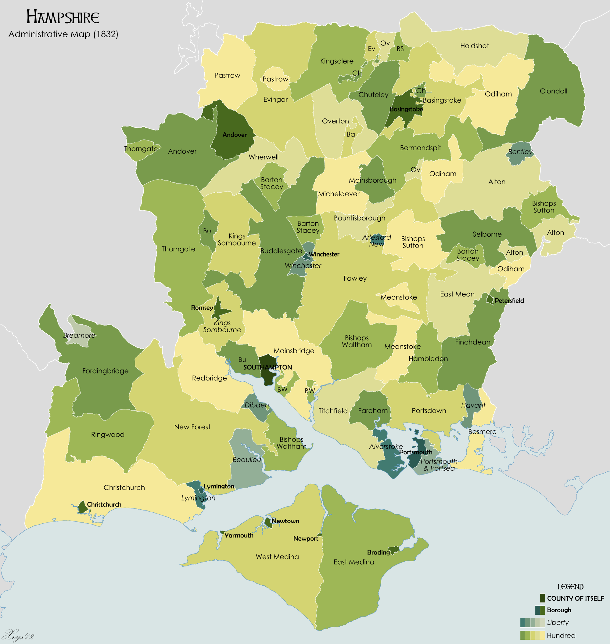
In the 19th century, the hundreds were listed as:
Herefordshire
The hundreds mentioned in the Domesday Survey and the hundreds of the Hundred Rolls of 1274 differ very widely in name and extent both from each other and from the ten hundreds of the present day. Not included in the hundreds of Herefordshire at the time of Domesday, the sparsely populated Welch area of Archenfield included Ashe Ingen, Baysham and Kings Caple.
From Domesday (1086):
*
Bromsash
*
Castlery
*
Cutestornes
*
Dinedor
*
Ewias
Ewyas ( cy, Ewias) was a possible early Welsh kingdom which may have been formed around the time of the Roman withdrawal from Britain in the 5th century. The name was later used for a much smaller commote or administrative sub-division, which cov ...
*
''Greitrewes''
*
Hazeltree – ''Hezetre''
*
Plegelgete
*
Radlow
*
Sellack
*
Stradel
*
Tornelaus
From ''
The National Gazetteer of Britain and Ireland
''The'' () is a grammatical article in English, denoting persons or things already mentioned, under discussion, implied or otherwise presumed familiar to listeners, readers, or speakers. It is the definite article in English. ''The'' is the m ...
'' (1868
Genuki: Miscellaneous Places, Herefordshire, Herefordshire*
Broxash
*
Ewyas-Lacy
*
Greytree
*
Grimsworth
*
Radlow
*
Stretford
*
Webtree
*
Wigmore
*
Wolphy
*
Wormelow (upper and lower divisions)
Hertfordshire
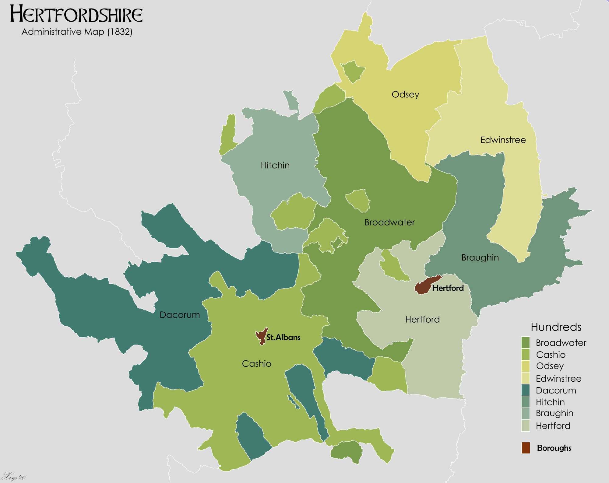 (Danais & Tring added as per
 History of Hertfordshire
Hertfordshire is an English county, founded in the Norse–Saxon wars of the 9th century, and developed through commerce serving London. It is a land-locked county that was several times the seat of Parliament. From origins in brewing and pap ...
)
*
Braughing
Braughing is a village and civil parish, between the rivers Quin and Rib, in the non-metropolitan district of East Hertfordshire, part of the English county of Hertfordshire. Braughing gave its name to a county division in Hertfordshire, kn ...
*
Broadwater
*
Cashio (Previously known as St Albans Hundred)
*
Dacorum
The Borough of Dacorum is a local government district in Hertfordshire, England that includes the towns of Hemel Hempstead, Berkhamsted, Tring and Kings Langley. The district, which was formed in 1974, had a population of 137,799 in 2001. I ...
*
Danais (merged with Tring
Tring is a market town and civil parish in the Borough of Dacorum, Hertfordshire, England. It is situated in a gap passing through the Chiltern Hills, classed as an Area of Outstanding Natural Beauty, from Central London. Tring is linked to ...
to form Dacorum
The Borough of Dacorum is a local government district in Hertfordshire, England that includes the towns of Hemel Hempstead, Berkhamsted, Tring and Kings Langley. The district, which was formed in 1974, had a population of 137,799 in 2001. I ...
)
*
Edwintree
*
Hertford
*
Hitchinbr>
The hundred of Hitchin: Introduction and map , British History Online*
Odsey
*
Tring
Tring is a market town and civil parish in the Borough of Dacorum, Hertfordshire, England. It is situated in a gap passing through the Chiltern Hills, classed as an Area of Outstanding Natural Beauty, from Central London. Tring is linked to ...
(merged with Danais to form Dacorum
The Borough of Dacorum is a local government district in Hertfordshire, England that includes the towns of Hemel Hempstead, Berkhamsted, Tring and Kings Langley. The district, which was formed in 1974, had a population of 137,799 in 2001. I ...
)
Huntingdonshire
*
Hurstingstone
*
Leightonstone
*
Norman Cross
Norman Cross Prison in Huntingdonshire, England, was the world's first purpose-built prisoner-of-war camp or "depot", built in 1796–97 to hold prisoners of war from France and its allies during the French Revolutionary Wars and Napoleonic War ...
*
Toseland
Kent

From Kent Genealog
Kent Genealogy England Early Medieval Kent was traditionally divided into East and West Kent, and into
lathes and hundreds.
The hundreds contained parishes and portions of parishes. In many regions of England as well as Kent, an entire parish would be within one hundred, yet especially along rivers and estuaries which had previously seen invasion, the Kentish hundreds were smaller in area and "shared" parishes to institutionalize resiliency and collective responsibility for defence and justice.
East Kent
Lathe of St. Augustine
The Lathe of St Augustine is an historic division of the county of Kent, England, encompassing the present-day Districts of Canterbury, Dover and Thanet The Lathes of Kent were ancient administration divisions originating, probably, in the 6 ...
Lathe of Scraye
Lathe of Scraye formed by mid-1200s from the half lathe of Milton (which consisted of the hundred of Milton and the Isle of Sheppey) and the Lathe of Wye (which consisted of the Isle of Harty (which is conjoined to the Isle of Sheppey) and many additional hundreds.
Due to a judicial administrative reform in the mid-19th century, the some hundreds of the Lathe of Scray were moved from East Kent administration to West Kent administration:
Lathe of Shepway
The Lathe of Shepway also included the
Cinque Port
The Confederation of Cinque Ports () is a historic group of coastal towns in south-east England – predominantly in Kent and Sussex, with one outlier ( Brightlingsea) in Essex. The name is Old French, meaning "five harbours", and alludes to t ...
Liberty of New Romney in
Romney Marsh
Romney Marsh is a sparsely populated wetland area in the counties of Kent and East Sussex in the south-east of England. It covers about . The Marsh has been in use for centuries, though its inhabitants commonly suffered from malaria until th ...
,
[Kent Archaeology: The Cinque Port Liberty of Romney]
Archaeologia Cantiana Vol. 13 1880 (p. 261). Accessed 13 February 2022. with the parish of
Lydd
Lydd is a town and electoral ward in Kent, England, lying on Romney Marsh. It is one of the larger settlements on the marsh, and the most southerly town in Kent. Lydd reached the height of its prosperity during the 13th century, when it was a c ...
as a limb of the Liberty.
West Kent
Lathe of Sutton at Hone
The Lathe of Sutton-at-Hone historically included a large part of Kent: the present-day boroughs of Dartford, Bexley, Greenwich, Bromley, Lewisham, Sevenoaks District and small parts of the Borough of Tonbridge and Malling and Borough of Tunbr ...
Lathe of Aylesford
plus the
Lowey of Tonbridge
The Lowey of Tonbridge is the name of a large tract of land given to Richard Fitz Gilbert (1024–1090) in West Kent, England by William the Conqueror after the Norman conquest of England.
Richard was a cousin of William's, both being descen ...
Lathe of Scraye (part)
In 1857 the provisions of the Act of 9 Geo. IV were invoked to re-examine the whole structure of Lathes and their divisions in providing for the administration of justice. The Lower Division of the Lathe of Scray, which formed the southernmost part of the Lathe, became part of West Kent, and consisted of the following Hundreds:
Lancashire

*
Amounderness
The Amounderness Hundred () is one of the six subdivisions of the historic county of Lancashire in North West England, but the name is older than the system of hundreds first recorded in the 13th century and might best be described as the nam ...
*
Blackburn
Blackburn () is an industrial town and the administrative centre of the Blackburn with Darwen borough in Lancashire, England. The town is north of the West Pennine Moors on the southern edge of the Ribble Valley, east of Preston and north-n ...
*
Leyland
*
Lonsdale
*
Salford
Salford () is a city and the largest settlement in the City of Salford metropolitan borough in Greater Manchester, England. In 2011, Salford had a population of 103,886. It is also the second and only other city in the metropolitan county afte ...
*
West Derby
West Derby ( ) is an affluent suburb of Liverpool, England. It is located East of the city and is also a Liverpool City Council ward. At the 2011 Census, the population was 14,382.
History West Derby
Mentioned in the ''Domesday Book'', Wes ...
Leicestershire
Leicestershire was originally divided into four wapentakes, but these were usually later described as hundreds. From the 1911 Encyclopædia Britannica after 1346 the six hundreds were:
*
East Goscote
East Goscote is a modern village and civil parish in the Borough of Charnwood district of Leicestershire, England, just north of the market town of Syston. It is a medium-sized village, with a population measured at 2,866 in the 2011 censu ...
*
Framland
Framland was a hundred in north-east Leicestershire, England, roughly corresponding to today's borough of Melton. It was recorded in the ''Domesday Book'' as one of Leicestershire's four wapentakes.
The name remains in use as a deanery of the Dioc ...
*
Gartree Gartree could refer to
*Gartree (HM Prison), a Category B men's prison located in Market Harborough, Leicestershire
*Gartree Hundred, a wapentake and later a hundred of Leicestershire, England
*Gartree High School, a Secondary School in Leicester ...
*
Guthlaxton
Guthlaxton is an ancient hundred of Leicestershire. Its jurisdiction was in the south of the county, and covered Lutterworth and Wigston Magna. At the time of the Domesday Book, it was one of Leicestershire's four wapentakes, and covered a muc ...
*
Sparkenhoe Sparkenhoe was a hundred of Leicestershire, England in the south-west of the county, covering Market Bosworth and Hinckley, broadly corresponding to the modern districts of Blaby and Hinckley and Bosworth.
The meeting place of the Sparkenhoe Hund ...
*
West Goscote
West Goscote was a hundred of Leicestershire, that arose from the division of the ancient Goscote hundred into two. It covers the north west of the county, an area broadly corresponding to the western part of Charnwood district along with North ...
In the
Domesday Book
Domesday Book () – the Middle English spelling of "Doomsday Book" – is a manuscript record of the "Great Survey" of much of England and parts of Wales completed in 1086 by order of King William I, known as William the Conqueror. The manusc ...
, West Goscote and East Goscote made up just
Goscote
Goscote was a wapentake in the county of Leicestershire, England; consisting of the north and north-west of the county. It was recorded in the Domesday Book, but as the wapentakes evolved to form hundreds, was split into East Goscote Hundred
...
and Sparkenhoe did not yet exist. The division which brought East and West Goscote and Sparkenhoe into existence was made in 1346.
Lincolnshire

Lincolnshire was divided into three Parts, each of which was divided into wapentakes, analogous to hundreds.
From map on
Lincolnshire County Council
Lincolnshire (abbreviated Lincs.) is a county in the East Midlands of England, with a long coastline on the North Sea to the east. It borders Norfolk to the south-east, Cambridgeshire to the south, Rutland to the south-west, Leicestershire an ...
website:
;
Parts of Holland
The Parts of Holland is a historical division of Lincolnshire, England, encompassing the south-east of the county. The name is still recognised locally and survives in the district of South Holland.
Administration
Parts of Holland was one of th ...
*
Elloe
*
Kirton
*
Skirbeck
Skirbeck is a suburb and former civil parish in the Borough of Boston in the county of Lincolnshire, England. Skirbeck is a long v-shaped formation wrapped around the south and east side of Boston parish. It has been incorporated into the Boroug ...
;
Parts of Kesteven
*
Aswardhurn
*
Aveland
*
Boothby Graffoe
Boothby Graffoe is a village and civil parish in the North Kesteven district of Lincolnshire, England. The population of the civil parish at the 2011 census was 223. It is situated approximately south from the city and county town of Lincoln, ...
(Higher and Lower divisions)
*
Beltisloe
Beltisloe is a Deanery of the Diocese of Lincoln in England, and a former Wapentake.
The Wapentake of Beltisloe was established as ancient administrative division of the English county of Lincolnshire before the Norman Conquest of 1066.
*
Flaxwell
*
Langoe (First and Second divisions)
*
Loveden
Loveden is a Deanery of the Diocese of Lincoln, England, and a former Wapentake.
Loveden is located broadly to the North of Grantham and includes the villages from Long Bennington in the west to Culverthorpe in the east, and from Welby in th ...
*
Ness
*
Winnibriggs and Threo (wapentake)
;
Parts of Lindsey
The Parts of Lindsey are a traditional division of Lincolnshire, England, covering the northern part of the county. The Isle of Axholme, which is on the west side of the River Trent, has normally formed part of it. The district's name origina ...
;North Riding of Lindsey
*
Bradley-Haverstoe
*
Ludborough
Ludborough is a village and civil parish in the East Lindsey district of Lincolnshire, England. It is situated approximately north from Louth, and at the eastern end of the A18 road. Ludborough has a population of 191 people. The Prime Merid ...
*
Walshcroft (North and South divisions)
*
Yarborough
;South Riding of Lindsey
*
Calceworth (Marsh and Wold divisions)
*
Candleshoe
''Candleshoe'' is a 1977 American-British family adventure–comedy film, directed by Norman Tokar in a screenplay by David Swift and Rosemary Anne Sisson, produced by Walt Disney Productions, and distributed by Buena Vista. Based on the Mich ...
(Marsh and Wold divisions)
*
Gartree Gartree could refer to
*Gartree (HM Prison), a Category B men's prison located in Market Harborough, Leicestershire
*Gartree Hundred, a wapentake and later a hundred of Leicestershire, England
*Gartree High School, a Secondary School in Leicester ...
(North and South divisions)
*
Hill
A hill is a landform that extends above the surrounding terrain. It often has a distinct summit.
Terminology
The distinction between a hill and a mountain is unclear and largely subjective, but a hill is universally considered to be not a ...
*
Louth-Eske (Marsh and Wold divisions)
*
Wraggoe (East and West divisions)
;West Riding of Lindsey
*
Aslacoe (East and West divisions)
*
Corringham
*
Epworth (compare
Isle of Axholme
The Isle of Axholme is a geographical area in England: a part of North Lincolnshire that adjoins South Yorkshire. It is located between the towns of Scunthorpe and Gainsborough, both of which are in the traditional West Riding of Lindsey, and ...
)
*
Manley (East, North, and West divisions)
*
Lawress
*
Well
A well is an excavation or structure created in the ground by digging, driving, or drilling to access liquid resources, usually water. The oldest and most common kind of well is a water well, to access groundwater in underground aquifers. The ...
Middlesex
*
Edmonton
Edmonton ( ) is the capital city of the Canadian province of Alberta. Edmonton is situated on the North Saskatchewan River and is the centre of the Edmonton Metropolitan Region, which is surrounded by Alberta's central region. The city ancho ...
*
Elthorne
*
Gore
Gore may refer to:
Places Australia
* Gore, Queensland
* Gore Creek (New South Wales)
* Gore Island (Queensland)
Canada
* Gore, Nova Scotia, a rural community
* Gore, Quebec, a township municipality
* Gore Bay, Ontario, a township on Manitouli ...
*
Isleworth (recorded in 1086 as Hounslow)
*
Ossulstone
Ossulstone is an obsolete subdivision (hundred) covering 26.4% of – and the most metropolitan part – of the historic county of Middlesex, England.British History Online Hundreds of Middlesex/ref> It surrounded but did not include the ...
*
Spelthorne
Spelthorne may refer to:
* Borough of Spelthorne, a local government district in the county of Surrey, England
* Spelthorne (UK Parliament constituency), Surrey constituency in the British House of Commons
* Spelthorne College, was a single-cam ...
Norfolk
Northamptonshire
In 1086, there were 39 hundreds in the county:
[Open Domesday: Northamptonshire.]
Accessed 22 January 2022. Alboldstow, Alwardsley, Barcheston, Beltisloe, Bloxham, Bumbelowe, Cleyley, Coleshill, Collingtree, Corby, Cuttlestone, Fawsley (Foxley), Gravesend (later absorbed into Fawsley Hundred), Guilsborough, Hamfordshoe, Higham, Hunesberi, Huxloe, Kirtlington, Mawsley, Navisford, Navisland, Ness, Nobottle, Offlow, Orlingbury, Polebrook, Rothwell, Spelhoe, Stoke (By the time of the 'Nomina Villarum' a survey carried out in the first half of the 12th century, the Stoke Hundred had been absorbed into the Corby Hundred), Stotfold, Sutton, Towcester, Upton, Warden, Willybrook, Witchley, Wootton and Wymersley.
From the Northamptonshire Family History Society the hundreds in the 1800s are:
The liberty and
Soke of Peterborough
The Soke of Peterborough is a historic area of England associated with the City and Diocese of Peterborough, but considered part of Northamptonshire. The Soke was also described as the Liberty of Peterborough, or Nassaburgh hundred, and comp ...
was sometimes called Nassaburgh hundred.
Northumberland
Following the
Harrying of the North and subsequent incursions from Scotland, the high sheriff of Northumberland was granted extraordinary powers. The county was subdivided into baronies, which were arranged in six wards and subdivided into constabularies. The wards were analogous to hundreds. From the ''National Gazetteer of Britain and Ireland'' (1868
GENUKI: The National Gazetteer of Great Britain and Ireland (1868) - Northumberland
*
Bamburgh
Bamburgh ( ) is a village and civil parish on the coast of Northumberland, England. It had a population of 454 in 2001, decreasing to 414 at the 2011 census.
The village is notable for the nearby Bamburgh Castle, a castle which was the seat of ...
*Castle (ward), Castle
*Coquetdale (ward), Coquetdale
*Glendale (ward), Glendale
*Morpeth (ward), Morpeth
*Tynedale (ward), Tynedale
Nottinghamshire

Nottinghamshire was divided into wapentakes, analogous to hundreds. From the Thoroton Society of Nottinghamshire]
The Thoroton Society of Nottinghamshire: Nottinghamshire
*Bassetlaw (wapentake), Bassetlaw (North Clay, South Clay and Hatfield divisions)
*Bingham (wapentake), Bingham (North and South divisions)
*Broxtowe (wapentake), Broxtowe (North and South divisions)
*Newark (wapentake), Newark (North and South divisions)
*Rushcliffe (wapentake), Rushcliffe (North and South divisions)
*Thurgarton (wapentake), Thurgarton (North and South divisions)
Oxfordshire
From
*Bampton, Oxfordshire (hundred), Bampton
*Banbury (hundred), Banbury
*Binfield (hundred), Binfield
*Bloxham (hundred), Bloxham
*Bullingdon (hundred), Bullingdon
*Chadlington (hundred), Chadlington
*Dorchester (hundred), Dorchester
*Ewelme (hundred), Ewelme (Known as Benson hundred in 1070)
*Kirtlington - A hundred at the time of Domesday, it was combined to form the major portion of Ploughley hundred by 1169.
*Langtree (hundred), Langtree
*Lewknor (hundred), Lewknor
*Pyrton (hundred), Pyrton - Pirton is a later Latinised spelling.
*Ploughley (hundred), Ploughley - Name first mentioned in the form ''Pokedelawa'' hundred in the Pipe Roll of 1169.
*Thame (hundred), Thame
*Wootton (hundred), Wootton - Includes the three hundreds dependent on the royal manor of Wootton, West Oxfordshire, Wootton in 1086 and sometimes called the "three hundreds of Wootton" in the later 12th century: Shipton hundred, (unknown name) hundred and pre-1086 Wootten hundred. The hundred was later divided into two administrative regions:
**Wootton (Northern part) - 19 parishes including Barford St. Michael, Deddington, Glympton, Heythrop, Rousham, Sandford St. Martin, South Newington, Stonesfield, Tackley, Wootton, West Oxfordshire, Wootton, the Astons (North Aston and Steeple Aston), the Bartons (Steeple Barton and Westcott Barton), the Worton (civil parish), Oxfordshire, Wortons (formed in 1932 by combining Nether Worton and Over Worton parishes), and the three Tews (Great Tew, Little Tew and Duns Tew).
**Wootton (Southern part) - 15 parishes and several extraparochial places
**Within Woolton hundred yet separately administered were the areas of Oxford City & University, Oxford City and Oxford Liberty.
Rutland

*Alstoe (hundred), Alstoe
*East (hundred of Rutland), East
*Martinsley (hundred), Martinsley
*Oakham (hundred), Oakham
*Wrandike (hundred), Wrandike
Shropshire
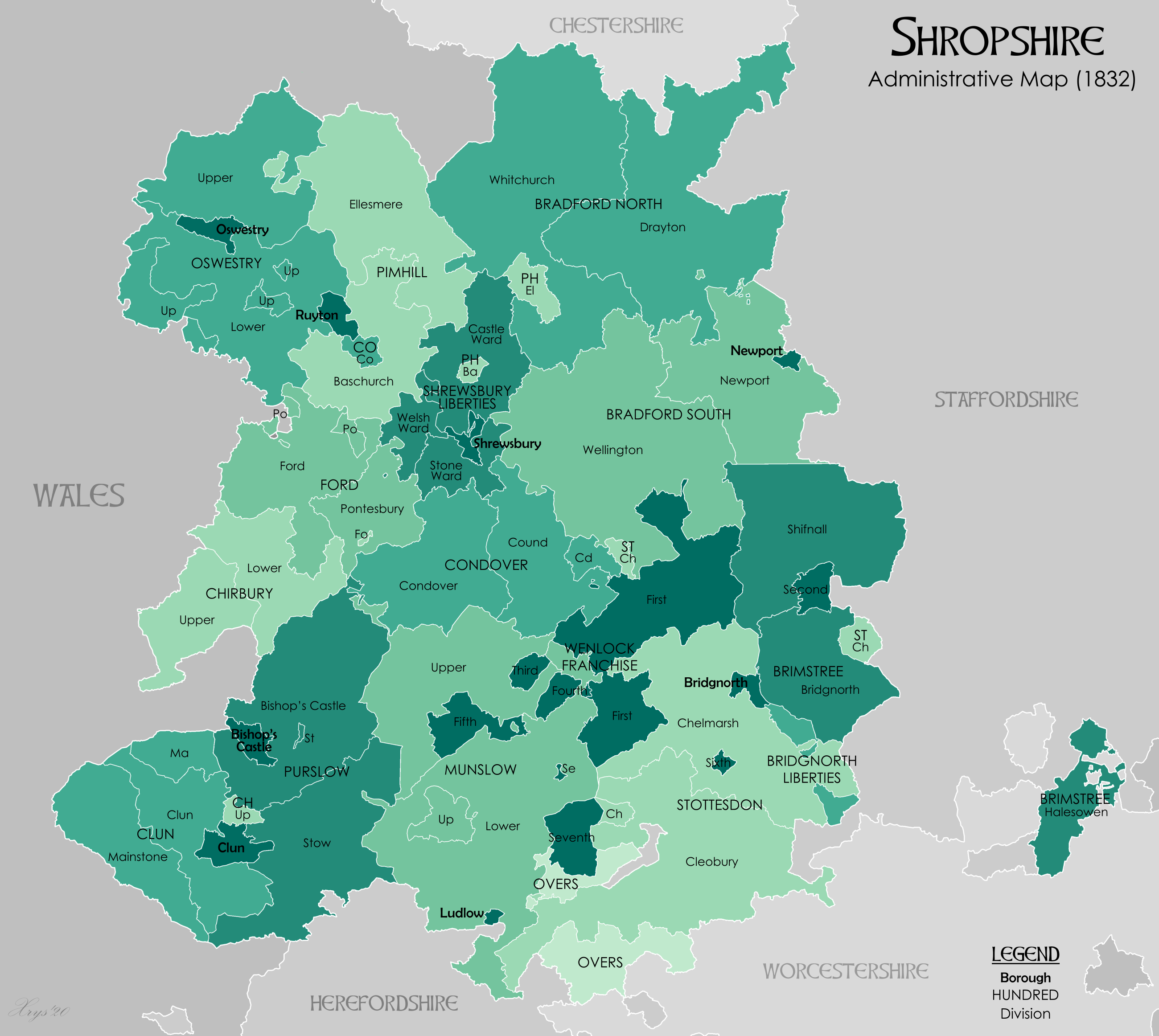
From GENUKI
† — including the Shropshire (Detached), Shropshire exclave of Halesowen (medieval parish), Halesowen
‡ The liberties of the borough of Shrewsbury and priory/borough of Much Wenlock, Wenlock were extensive and are usually considered as hundreds (Wenlock was sometimes described as the "franchise of Wenlock").
Somerset
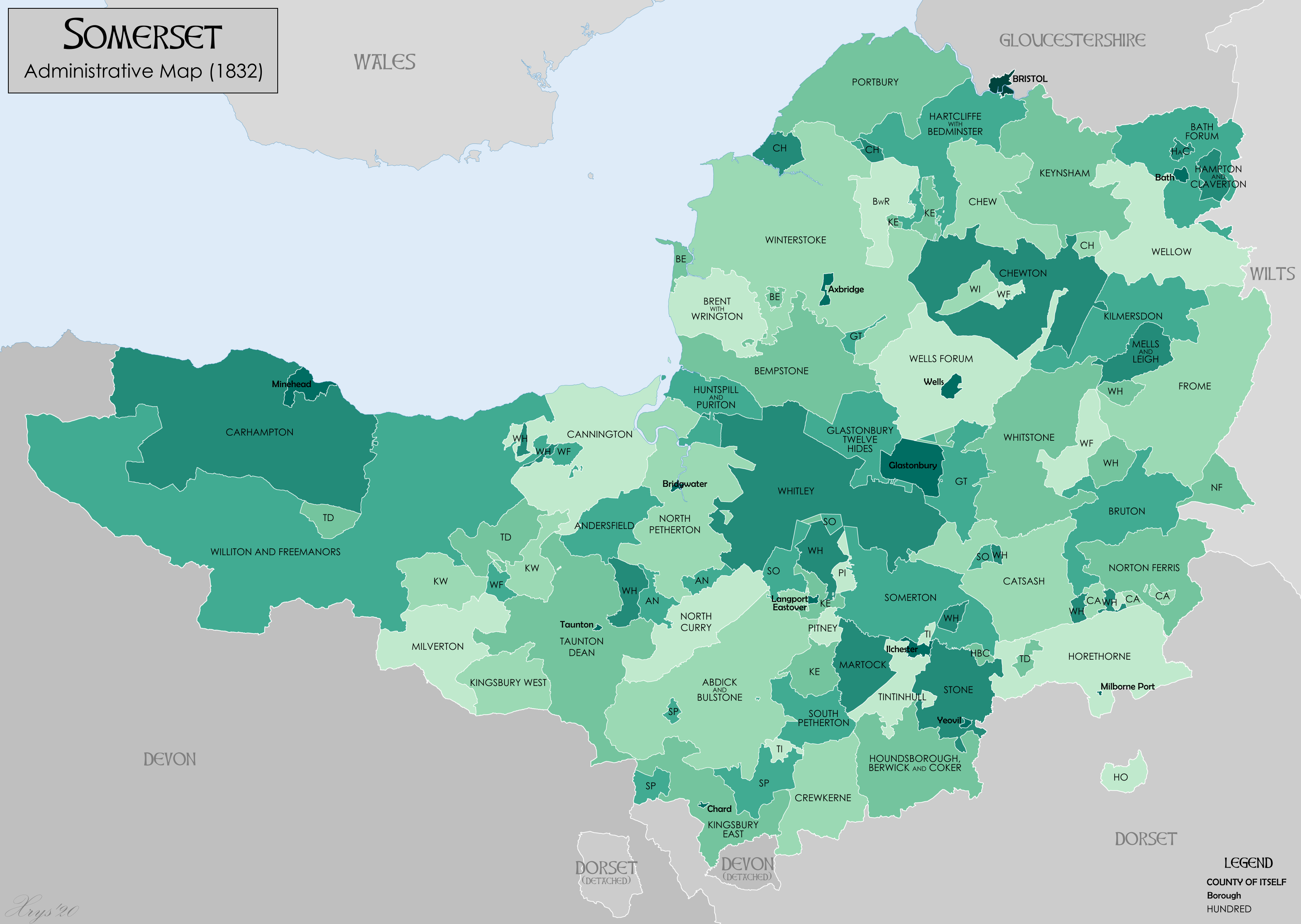
From the
National Gazetteer of Britain and Ireland'
Staffordshire
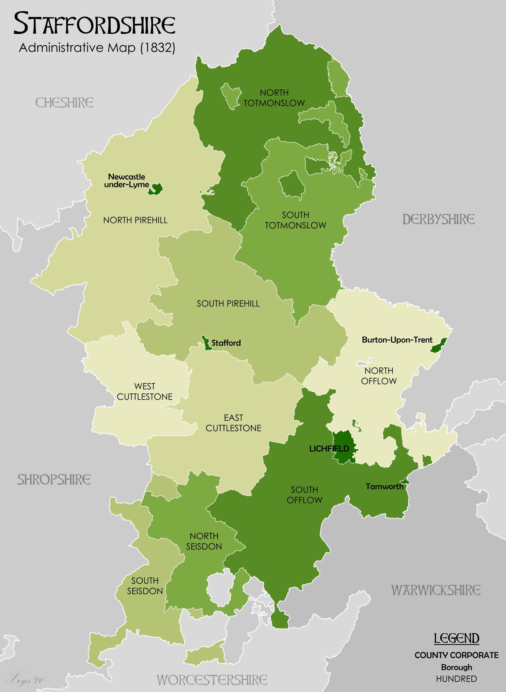
From GENUKI
*Cuttleston, East Cuttlestone
*Cuttleston, West Cuttlestone
*Offlow, North Offlow
*Offlow, Souh Offlow
*Pirehill Hundred, North Pirehill
*Pirehill Hundred, South Pirehill
*Seisdon, North Seisdon
*Seisdon, South Seisdon
*Totmonslow, North Totmonslow
*Totmonslow, South Totmonslow
Suffolk
Surrey
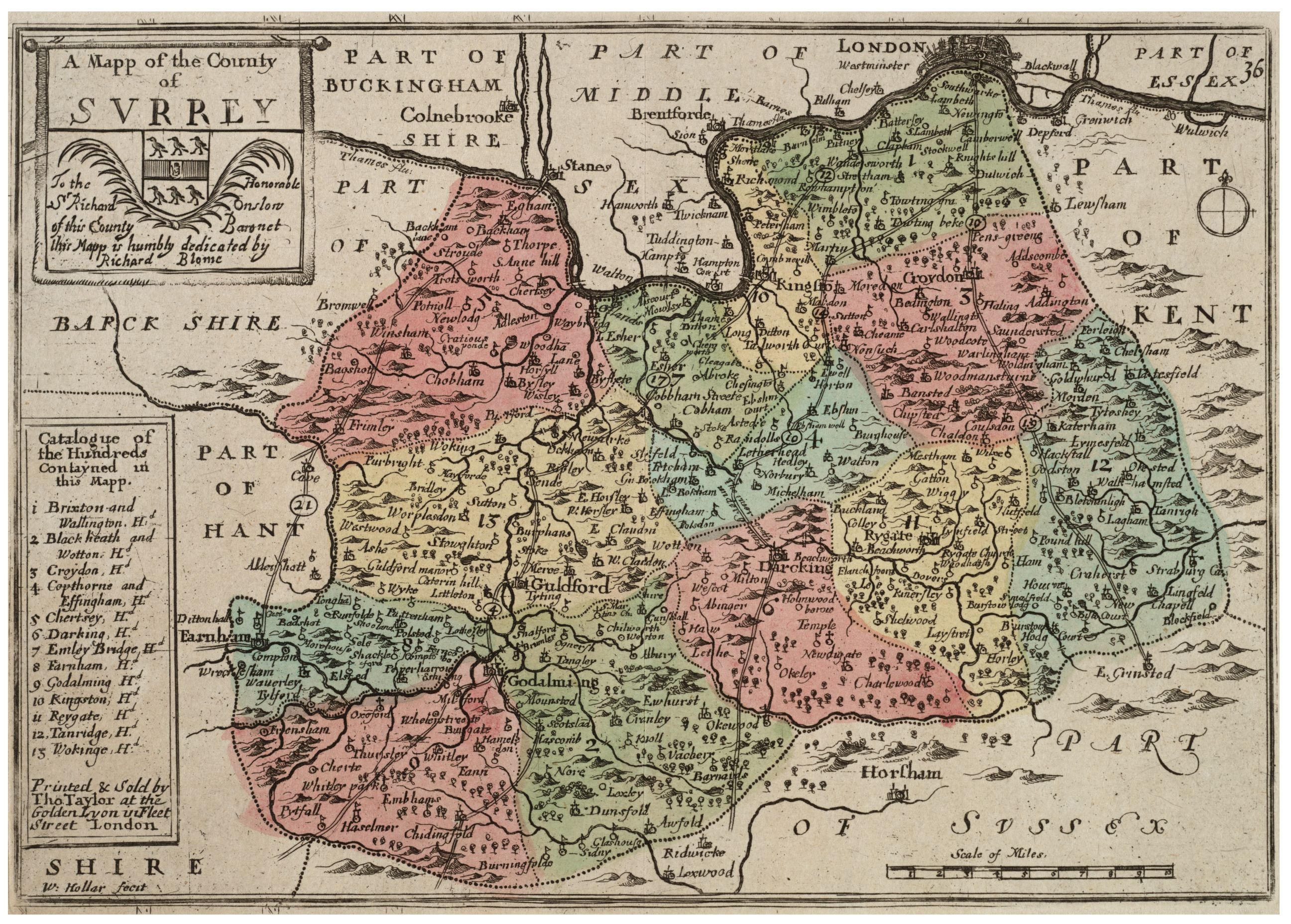
There are thirteen hundreds and one half hundred:
Sussex

Sussex was divided into Rape (county subdivision), rapes, and then hundreds.
Arundel Rape
The Arundel Rape covered nearly all of what is now West Sussex until about 1250, when it was split into two rapes the Arundel Rape and the Chichester Rape.
In 1834 it contained five hundreds sub-divided into fifty six parishes.
[Horsfield. History of Sussex. Volume II pp.105-184]
*Avisford
*Bury, West Sussex, Bury
*Poling, West Sussex, Poling
*Rotherbridge
*West Easwrith
Bramber Rape
The Bramber Rape lies between the Rape of Arundel in the west and Lewes in the east. In 1834 it contained 40 parishes
[Horsfield. History of Sussex. Volume II pp.185-274] in the following hundreds:
* Brightford
* Burbeach
* West Grinstead (Grensted in the Domesday Book, Domesday Survey)
* Poling, West Sussex, Poling (once known as Rieberge)
* Singlecross
* Steyning
* Tarring, West Sussex, Tarring (a Royal Peculiar, peculier of the Archbishop of Canterbury)
* Tipnoak
as well as 3 half hundreds
* East Easwrith
* Fishersgate
* Wyndham
Chichester Rape
The combined Chichester and Arundel Rape covered nearly all of what is now West Sussex until about 1250, when it was split into two rapes the Arundel Rape and the Chichester Rape.
In 1834 it contained seven hundreds and seventy-four parishes.
[Horsfield. History of Sussex. Volume II pp.1-104]
*Aldwick (hundred), Aldwick
*
Bosham
*Box and Stockbridge (hundred), Box and Stockbridge
*Dumpford (hundred), Dumpford
*Easebourne (hundred), Easebourne
*Manhood Peninsula, Manhood
*Westbourne and Singleton (hundred), Westbourne and Singleton
Hastings Rape
Medieval sources talk of a group of people who were separate to that of the South Saxons they were known as the Haestingas. The area of Sussex they occupied became the Rape of Hastings.
It encompassed the easternmost part of Sussex, with the county of Kent to its east and the Rape of Pevensey to its west. The Anglo-Saxon hundred of Hailesaltede was later partitioned into Battle Hundred and Netherfield Hundred. In 1833, the Rape of Hastings had 13 hundreds giving a total of about 154,060 acres.
[Horsfield. History of Sussex. Volume II pp.425-592]
* Baldstrow
* Battle, East Sussex, Battle
* Bexhill, East Sussex, Bexhill
* Foxearle
* Goldspur
* Gostrow
* Guestling
* Hawkesborough
* Henhurst
* Netherfield
* Ninfield
* Shoyswell
* Staple
Lewes Rape
The Rape of Lewes is bounded by the Rape of Bramber on its west and the Rape of Pevensey on its east. Although it had the same amount of hundreds in 1833 as in the Domesday survey, there had been some cases of manors and parishes been taken from one and added to another hundred, and in other cases the hundreds had been divided and lost.
[Horsfield. History of Sussex. Volume I pp.103-268.]
*Barcombe (hundred), Barcombe
*Buttinghill (hundred), Buttinghill
*Dean (hundred), Dean
*Fishergate (hundred), Fishergate
*Holmestrow (hundred), Holmestrow
*Poynings (hundred), Poynings
*Preston (hundred), Preston
*Street (hundred), Street
*Swanborough (hundred of Sussex), Swanborough
*Whalesbourne (hundred), Whalesbourne
*Younsmere hundred, Younsmere (also Falmer (hundred), Falmer)
Pevensey Rape
The Pevensey Rape lies between the Rapes of Lewes and Hastings. In 1833 it contained 19 hundreds and 52 parishes
[Horsfield. History of Sussex. Volume I pp.269-424]
*Alciston (hundred), Alciston
*Bishopstone (hundred), Bishopstone
*Danehill Horsted (hundred), Danehill Horsted
*Dill (hundred), Dill
*Eastbourne
*East Grinstead (Grinsted in the Domesday survey)
*Flexborough (hundred), Flexborough
*Hartfield (hundred), Hartfield
*Lindfield Burley Arches (hundred), Lindfield Burley-Arches (also Burarches (hundred), Burarches)
*Pevensey#The Liberty of Pevensey, Lowey or Liberty of Pevensey - Part of Port of Hastings, so having the immunities and privileges of the Cinque Ports.
*Loxfield-Camden (hundred), Loxfield Camden
*Loxfield Dorset (hundred), Loxfield Dorset
*Longbridge (hundred), Longbridge
*Ringmer (hundred), Ringmer
*Rotherfield (hundred), Rotherfield
*Rushmonden (hundred), Rushmonden
*Shiplake (hundred), Shiplake
*Totnore (hundred), Totnore
*Willingdon (hundred), Willingdon
Warwickshire
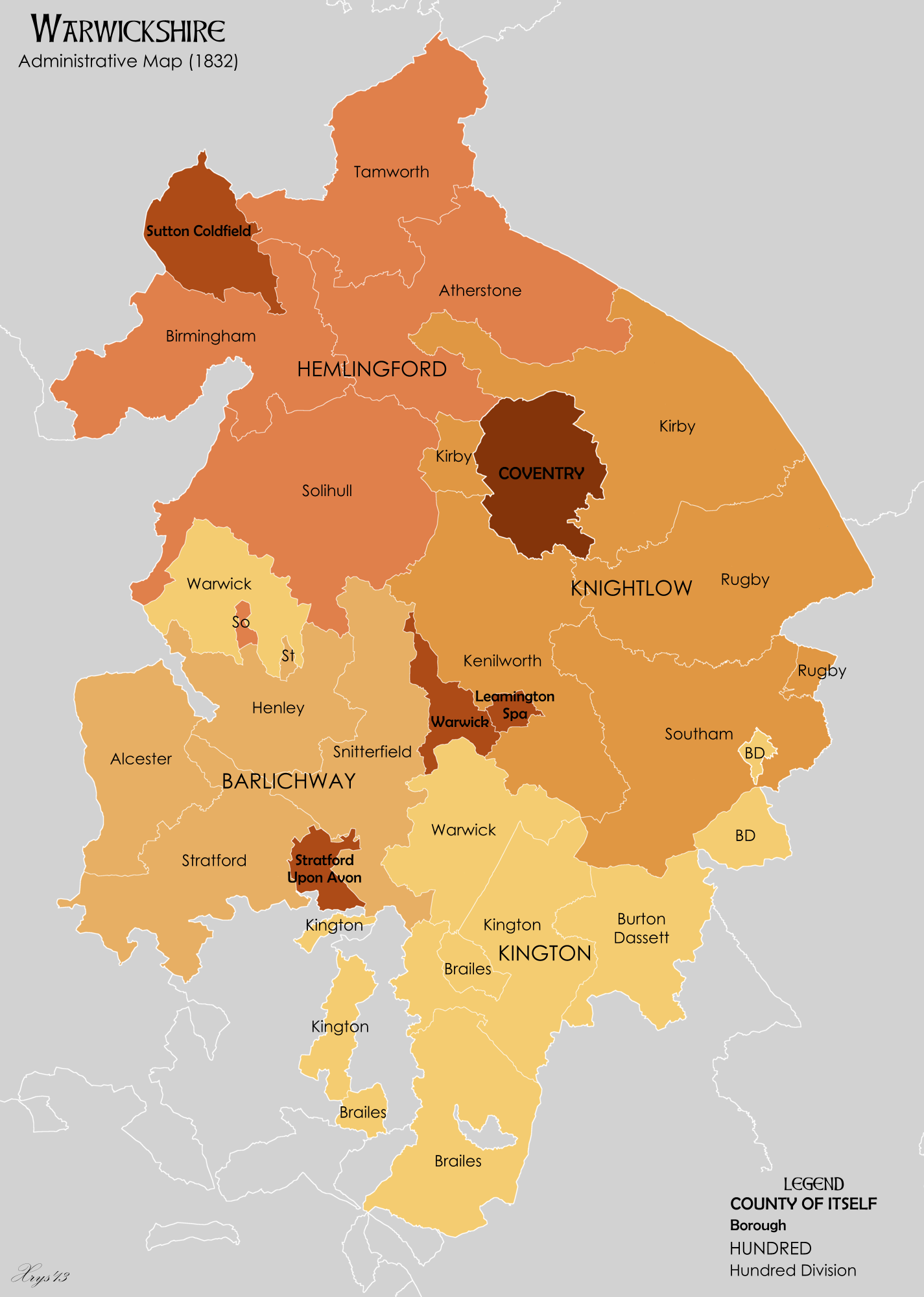
Warwickshire was divided into four hundreds, with each hundred consisting of a number of divisions.
*Barlinchway (hundred), Barlinchway (also Barlichway)
** Alcester
** Henley
** Snitterfield
** Stratford
*Hemlingford (hundred), Hemlingford, formerly named Coleshill
** Atherstone
** Birmingham
** Solihull
** Tamworth
*Kington (hundred), Kington (also Kineton)
** Brailes
** Burton Dassett
** Kington
** Warwick
*Knightlow (hundred), Knightlow
** Kenilworth
** Kirby
** Rugby
** Southam
Westmorland
Westmorland was divided into four wards, analogous to hundreds. Pairs of wards made up the two Baronies. From ''Magna Britannica et Hibernia'' (1736
Genuki: Westmorland, Westmorland
Barony of Kendal
The Barony of Kendal had two wards:
*Kendal (ward), Kendal
*Lonsdale (ward), Lonsdale
Barony of Westmorland
The Barony of Westmorland had two wards:
*East Ward
*West Ward
Wiltshire
There were History of Wiltshire#Wiltshire's hundreds, 40 hundreds in Wiltshire at the time of the Domesday Survey.
Hundreds in 1835 were:
Worcestershire
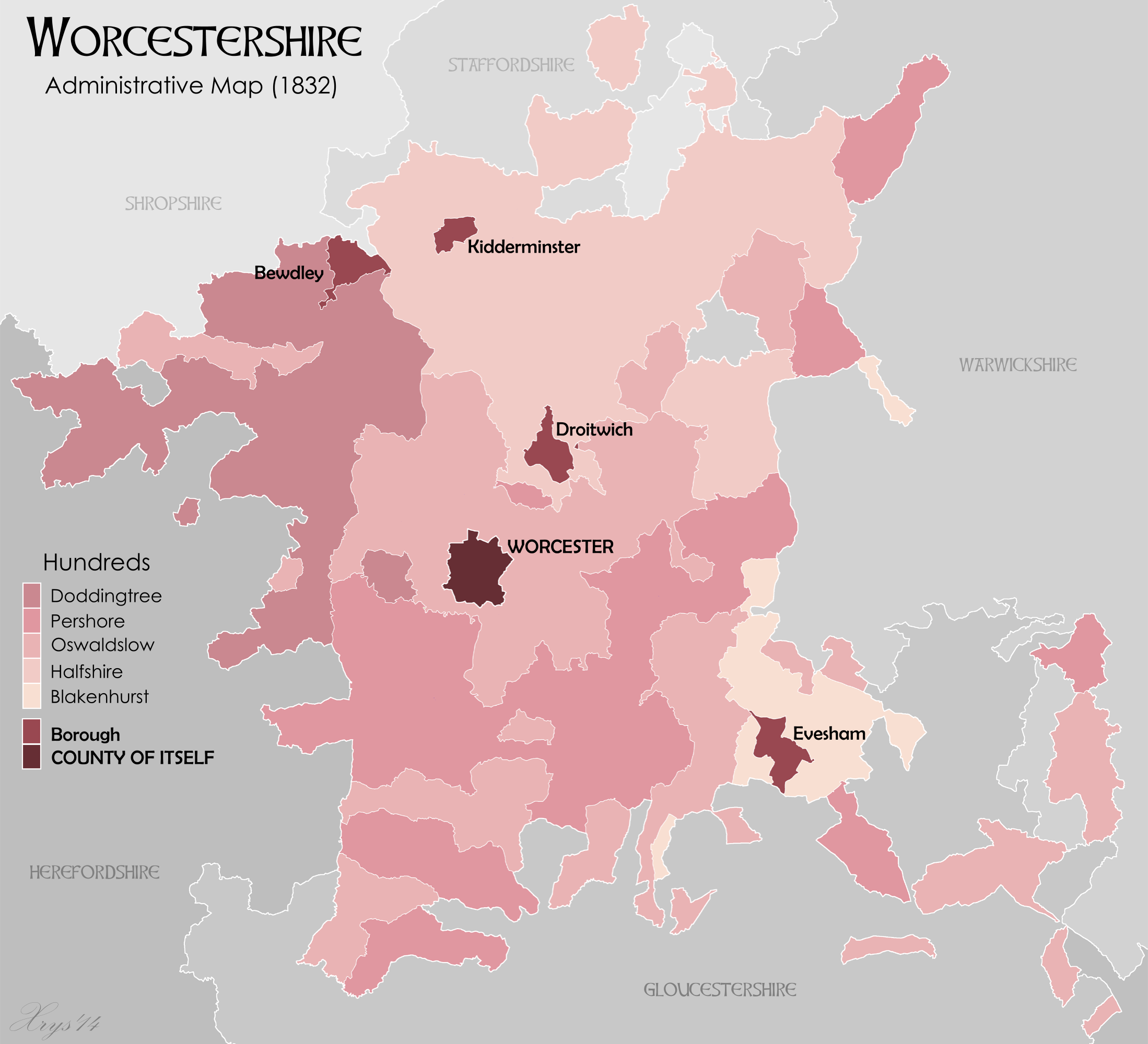
The ancient hundreds in 1086 at the time of the Domesday survey were:
Ash, Came, Celfledetorn, Clent, Cresslow, Cutestornes, Doddingtree, Dudstone, Fernecumbe, Fishborough, Greston, Ossulstone, Oswaldslow, Pershore, Plegelgete, Seisdon, Tewkesbury, Tibblestone, Wolfhay.
Some of the parishes within these hundreds, such as Feckenham in Ash Hundred, or Gloucester in Dudstone Hundred, may have partially been in other counties or were transferred between counties in the intervening years.
Over the centuries, some of the hundreds were amalgamated and appear in many useful statistical records. The hundreds that continued their courts until disuse include:
*Blackenhurst (hundred), Blackenhurst
*Doddingtree
*Halfshire – combined the Domesday hundreds of Clent and Cresslow
*Oswaldslow (hundred), Oswaldslow – combined three ancient hundreds
*Pershore (hundred), Pershore
Yorkshire

Yorkshire has three Ridings,
[ - Riding is taken from the Old Norse ''thrithjung '' meaning ''thirdings'' one third of an equally important area.] East Riding of Yorkshire, East, North Riding of Yorkshire, North and West Riding of Yorkshire, West. Each of these was divided into wapentakes, analogous to hundreds.
The Ainsty (wapentake), Ainsty wapentake, first associated with the West Riding, became associated in the fifteenth century with the City of York, outside the Riding system.
The hundreds of Amounderness and Lonsdale in Lancashire plus part of Westmorland were considered as part of Yorkshire in the
Domesday Book
Domesday Book () – the Middle English spelling of "Doomsday Book" – is a manuscript record of the "Great Survey" of much of England and parts of Wales completed in 1086 by order of King William I, known as William the Conqueror. The manusc ...
.
East Riding
From GENUK
GENUKI: Definitions of the terms used to describe areas of land and habitation in the county of Yorkshire.
*Buckrose
*Dickering Wapentake
*Harthill Wapentake (Bainton Beacon, Holme Beacon, Hunsley Beacon and Wilton Beacon divisions)
*Holderness Wapentake (North, Middle and South divisions)
*Howdenshire
*Ouse and Derwent
The other division of the riding was Hullshire.
North Riding
*Allerton (wapentake), Allerton
*Birdforth (wapentake), Birdforth
*Bulmer (wapentake), Bulmer
*Gilling East (wapentake), Gilling East
*Gilling West (wapentake), Gilling West
*Hallikeld
*Hang East
*Hang West
*Langbaurgh (wapentake), Langbaurgh (Langbaurgh West, West and Langbaurgh East, East divisions)
*Pickering Lythe (wapentake), Pickering Lythe – Formed from the Domesday wapentake of Dic, and additionally by 1284–85 the parish of Sinnington and by (circa 15th-16th century) the parish of Kirkby Misperton, both from the Domesday wapentake of Maneshou.
*Ryedale (wapentake), Ryedale – First mentioned by name in 1165–66, probably when its court was relocated there. Formed from the Domesday wapentake of Maneshou minus Sinnington and Kirkby Misperton parishes, plus the additional parish of Lastingham from the Domesday wapentake of Dic.
In the 19th century, Ryedale contained the parishes of Ampleforth; Appleton-Le-Street; Barton-Le-Street; Great Edston; Gilling; Helmsley; Hovingham; Kirkby Moorside; Kirkdale; Lastingham; New Malton, including the parishes of St. Leonard and St. Michael; Old Malton; Normanby; Nunnington; Oswaldkirk; Salton; Scawton; Slingsby; Stonegrave.
*Whitby Strand
West Riding
From GENUK
GENUKI: Definitions of the terms used to describe areas of land and habitation in the county of Yorkshire.
*Agbrigg and Morley (Agbrigg and Morley divisions)
*Ainsty (wapentake), Ainsty wapentake (___ and ___ divisions) (became a district named Ainsty of York in the 15th century)
*Barkston Ash Wapentake
*Claro Wapentake (Upper and Lower divisions) (Burghshire wapentake was renamed in the 12th century)
*Ewcross
*Osgoldcross Wapentake
*Skyrack (Upper and Lower divisions)
*Staincliffe Wapentake (East and West divisions)
*Staincross Wapentake
*Strafforth and Tickhill (Upper and Lower divisions)
The Hundreds of Wales

Wales was divided into hundreds following the
Laws in Wales Acts 1535 and 1542
The Laws in Wales Acts 1535 and 1542 ( cy, Y Deddfau Cyfreithiau yng Nghymru 1535 a 1542) were Acts of the Parliament of England, and were the parliamentary measures by which Wales was annexed to the Kingdom of England. Moreover, the legal sy ...
. This resulted in the creation of five new counties (Monmouthshire (historic), Monmouthshire, Brecknockshire, Radnorshire, Montgomeryshire and Denbighshire (historic), Denbighshire) from the Marches of Wales. Combined with the transformation of the Lordships of Pembroke and Glamorgan into new counties, with the existing counties of Cardiganshire, Caernarfonshire and Flintshire (created by the Statute of Rhuddlan) this gave Wales thirteen counties.
Anglesey
Anglesey was divided into six hundreds:
*Dindaethwy
*Llifon
*Malltraeth
*Menai (hundred), Menai
*Talybolion
*Twrcelyn
Brecknockshire
Brecknockshire was divided into six hundreds.
*Builth
*Crickhowell, Crucywel
*Deffynog, Defynnog
*Merthyr
*Penkelly, Pencelli
*Talgarth
Caernarvonshire
Caernarfonshire, Caernarvonshire was divided into ten hundreds:
* Cymydmaen, Commitmaen
*Rhos (North Wales), Creuddyn
*Dinllaen, Dinlaen
*Eifionydd
*Cafflogion
*Arllechwedd Isaf, Isaf
*Arllechwedd Isaf, Uchaf
* Nant Conwy, Nanconwy
*Is Gwyrfai
*Uwch Gwyrfai
Cardiganshire
Ceredigion, Cardiganshire was divided into five hundreds.
*Genaur Glyn
*Ilar
*Moyddyn
*Penarth
*Troedyraur
Carmarthenshire
Carmarthenshire was divided into eight hundreds.
*Carnwallon (hundred), Carnwyllion
*Cathinog (hundred), Catheiniog
*Cayo (hundred), Caeo
*Kidwelly (hundred), Cedweli
*Derllys (hundred), Derllys
*Elvet (hundred), Elfed
*Iscennen (hundred), Is Cennen
*Perfedd (hundred), Perfedd
Denbighshire
Denbighshire (historic), Denbighshire was divided into six hundreds:
* Maelor Gymraeg, Broomfield
*Chirk
*Is Aled
*Is Dulas
* Rhuthun, Ruthin
*Llanarmon-yn-Iâl, Yale
Flintshire
Flintshire (historic), Flintshire was divided into five hundreds:
*Coleshill
*Maelor, Maylor
*Mold, Flintshire, Mold
*Prestatyn
*Rhuddlan
Glamorgan
Glamorgan was divided into ten hundreds:
*Caerphilly (hundred), Caerphilly
*Cowbridge (hundred), Cowbridge
*Dinas Powis (hundred), Dinas Powys
*Kibbor (hundred), Kibbor
*Llangyfelach (hundred), Llangyfelach
*Miskin (hundred), Miskin
*Neath (hundred), Neath
*Newcastle (hundred), Newcastle
*Ogmore (hundred), Ogmore
*Swansea (hundred), Swansea
Merionethshire
Merionethshire was divided into five hundreds:
*Ardudwy
*Edernion
* Estimaner, Ystumanner
*Penllyn, Gwynedd, Penilyn
* Talybont with Mowddu, Tal Y Bon and Mawddwy
Monmouthshire
Monmouthshire was divided into five hundreds:
*Abergavenny (hundred), Abergavenny
*Caldicot (hundred), Caldicot
*Raglan (hundred), Rhaglan
*Skenfrith (hundred), Skenfrith
*Usk (hundred), Usk
*Wentloog (hundred), Wentloog
Montgomeryshire
Montgomeryshire was divided into eight hundreds:
*Cawrse
* Deythur, Deuddwr
*Llanfyllin
*Machynlleth
* Mathrafell, Mathrafal
*Montgomery, Powys, Montgomery
*Newtown, Powys, Newtown
* Welshpool, Pool
Pembrokeshire
Pembrokeshire was divided into seven hundreds:
*Castlemartin (hundred), Castlemartin
*Cemais (Dyfed cantref), Cemais
*Cilgerran (hundred), Cilgerran
*Dewisland (hundred), Dewisland
*Dungleddy (hundred), Dungleddy
*Narberth (hundred), Narberth
*Roose (hundred), Rhos
Radnorshire
Radnorshire was divided into six hundreds:
*Cefnllys
*Colwyn
*Knighton, Powys, Knighton
* Llanbedr, Painscastle
*New Radnor, Radnor
* Rhaeadr, Rhayader
References
;Bibliography
*
Notes on Wapentakes in Lincolnshire, from 'Introduction: Lost vills and other forgotten places', Final Concords of the County of Lincoln: 1244-1272 (1920), pp. L-LXV* {{Cite book, last=Horsfield, first=Thomas Walker, author-link=Thomas Walker Horsfield, year=1834, title=The History, Antiquities and Topography of the County of Sussex, isbn=978-1-906789-16-9, publisher=Country Books, location=Bakewell
Local government in the United Kingdom
Hundreds of England,
Hundreds of Wales,
Lists of hundreds in England,
 Most of the counties of
  *Barford
*
 The County of Berkshire comprised 20 Hundreds and 193 parishes and parts of four others. From
  Until at least the time of the
  Cambridgeshire was divided into 17 hundreds, plus the borough of
  From Harris, B. E., and Thacker, A. T. (1987). ''The Victoria History of the County of Chester. (Volume 1: Physique, Prehistory, Roman, Anglo-Saxon, and Domesday).'' Oxford: Oxford University Press. .
* Broxton
* Bucklow
* Eddisbury
*
 From GENUK
 Cumberland was divided into wards, analogous to hundreds. From the ''National Gazetteer of Britain and Ireland'
 The civil divisions of
  In 1850 there were thirty-two hundreds in Devon according to '' White's History, Gazetteer, and Directory of Devonshire''

 * Barstable (sometimes spelled Barnstable)
*
 The thirty-nine hundreds mentioned in the Domesday Survey and the thirty-one hundreds of the Hundred Rolls of 1274 differ very widely in name and extent both from each other and from the twenty-eight hundreds of the present day.
From the ''National Gazetteer of Britain and Ireland'
 In the 19th century, the hundreds were listed as:
 (Danais & Tring added as per
  From Kent Genealog
 *
* Lincolnshire was divided into three Parts, each of which was divided into wapentakes, analogous to hundreds.
From map on
  Nottinghamshire was divided into wapentakes, analogous to hundreds. From the Thoroton Society of Nottinghamshire]
 *Alstoe (hundred), Alstoe
*East (hundred of Rutland), East
*Martinsley (hundred), Martinsley
*Oakham (hundred), Oakham
*Wrandike (hundred), Wrandike
 From GENUKI
† — including the Shropshire (Detached), Shropshire exclave of Halesowen (medieval parish), Halesowen
‡ The liberties of the borough of Shrewsbury and priory/borough of Much Wenlock, Wenlock were extensive and are usually considered as hundreds (Wenlock was sometimes described as the "franchise of Wenlock").
 From the
  From GENUKI
*Cuttleston, East Cuttlestone
*Cuttleston, West Cuttlestone
*Offlow, North Offlow
*Offlow, Souh Offlow
*Pirehill Hundred, North Pirehill
*Pirehill Hundred, South Pirehill
*Seisdon, North Seisdon
*Seisdon, South Seisdon
*Totmonslow, North Totmonslow
*Totmonslow, South Totmonslow
 There are thirteen hundreds and one half hundred:
 Sussex was divided into Rape (county subdivision), rapes, and then hundreds.
 Warwickshire was divided into four hundreds, with each hundred consisting of a number of divisions.
*Barlinchway (hundred), Barlinchway (also Barlichway)
** Alcester
** Henley
** Snitterfield
** Stratford
*Hemlingford (hundred), Hemlingford, formerly named Coleshill
** Atherstone
** Birmingham
** Solihull
** Tamworth
*Kington (hundred), Kington (also Kineton)
** Brailes
** Burton Dassett
** Kington
** Warwick
*Knightlow (hundred), Knightlow
** Kenilworth
** Kirby
** Rugby
** Southam
 The ancient hundreds in 1086 at the time of the Domesday survey were:
Ash, Came, Celfledetorn, Clent, Cresslow, Cutestornes, Doddingtree, Dudstone, Fernecumbe, Fishborough, Greston, Ossulstone, Oswaldslow, Pershore, Plegelgete, Seisdon, Tewkesbury, Tibblestone, Wolfhay.
Some of the parishes within these hundreds, such as Feckenham in Ash Hundred, or Gloucester in Dudstone Hundred, may have partially been in other counties or were transferred between counties in the intervening years.
Over the centuries, some of the hundreds were amalgamated and appear in many useful statistical records. The hundreds that continued their courts until disuse include:
*Blackenhurst (hundred), Blackenhurst
*Doddingtree
*Halfshire – combined the Domesday hundreds of Clent and Cresslow
*Oswaldslow (hundred), Oswaldslow – combined three ancient hundreds
*Pershore (hundred), Pershore
 Yorkshire has three Ridings, - Riding is taken from the Old Norse ''thrithjung '' meaning ''thirdings'' one third of an equally important area. East Riding of Yorkshire, East, North Riding of Yorkshire, North and West Riding of Yorkshire, West. Each of these was divided into wapentakes, analogous to hundreds.
The Ainsty (wapentake), Ainsty wapentake, first associated with the West Riding, became associated in the fifteenth century with the City of York, outside the Riding system.
The hundreds of Amounderness and Lonsdale in Lancashire plus part of Westmorland were considered as part of Yorkshire in the
  Wales was divided into hundreds following the