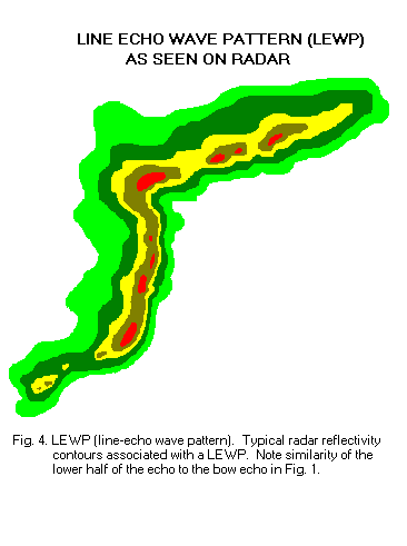
Line Echo Wave Pattern on:
[Wikipedia]
[Google]
[Amazon]
 A line echo wave pattern (LEWP) is a
 A LEWP is an extension of the concept of the bow echo, which usually indicates a powerful convective windstorm. Areas hit by the apices of bows often see the worst weather, with the highest winds and very heavy rain. However, if the sides of the bows reach enough of an orientation parallel to the derecho's movement, a very long-duration heavy rain event can result, leading to
 A line echo wave pattern (LEWP) is a
 weather radar
Weather radar, also called weather surveillance radar (WSR) and Doppler weather radar, is a type of radar used to locate precipitation, calculate its motion, and estimate its type (rain, snow, hail etc.). Modern weather radars are mostly puls ...
formation in which a single line of thunderstorms presenting multiple bow echo
A bow echo is the characteristic radar return from a mesoscale convective system that is shaped like an archer's bow. These systems can produce severe straight-line winds and occasionally tornadoes, causing major damage. They can also become de ...
es forms south (or equatorward) of a mesoscale low-pressure area
In meteorology, a low-pressure area, low area or low is a region where the atmospheric pressure is lower than that of surrounding locations. Low-pressure areas are commonly associated with inclement weather (such as cloudy, windy, with possible ...
with a rotating "head". LEWP often are associated with a multiple-bow serial derecho
A ''derecho'' (, from es, derecho, link=no , 'straight') is a widespread, long-lived, straight-line wind storm that is associated with a fast-moving group of severe thunderstorms known as a mesoscale convective system.
Derechos can cause hurri ...
and often produce tornadoes, some of which can be strong. The existence of a LEWP on radar means that a serial derecho
A ''derecho'' (, from es, derecho, link=no , 'straight') is a widespread, long-lived, straight-line wind storm that is associated with a fast-moving group of severe thunderstorms known as a mesoscale convective system.
Derechos can cause hurri ...
has developed or is likely to develop soon, much as a hook echo
A hook echo is a pendant or hook-shaped weather radar signature as part of some supercell thunderstorms. It is found in the lower portions of a storm as air and precipitation flow into a mesocyclone, resulting in a curved feature of reflectivity. ...
indicates the same for a tornado
A tornado is a violently rotating column of air that is in contact with both the surface of the Earth and a cumulonimbus cloud or, in rare cases, the base of a cumulus cloud. It is often referred to as a twister, whirlwind or cyclone, altho ...
.
Formation
A LEWP, according to the NWS, is defined as "asquall line
A squall line, or more accurately a quasi-linear convective system (QLCS), is a line of thunderstorms, often forming along or ahead of a cold front. In the early 20th century, the term was used as a synonym for cold front (which often are accompa ...
that has developed into a wave-like pattern due to acceleration at one end of the line and deceleration along the portion immediately adjacent."
 A LEWP is an extension of the concept of the bow echo, which usually indicates a powerful convective windstorm. Areas hit by the apices of bows often see the worst weather, with the highest winds and very heavy rain. However, if the sides of the bows reach enough of an orientation parallel to the derecho's movement, a very long-duration heavy rain event can result, leading to
 flash flood
A flash flood is a rapid flooding of low-lying areas: washes, rivers, dry lakes and depressions. It may be caused by heavy rain associated with a severe thunderstorm, hurricane, or tropical storm, or by meltwater from ice or snow flowing o ...
ing. A serial derecho can be in the form of a LEWP or a single, very large bow echo
A bow echo is the characteristic radar return from a mesoscale convective system that is shaped like an archer's bow. These systems can produce severe straight-line winds and occasionally tornadoes, causing major damage. They can also become de ...
. In theory, a LEWPs formation is dependent on varying environmental conditions in different regions of the respective LEWP. In many LEWPs, outflow induced winds behind the leading edge tend to influence this edge, appearing as a bulge in reflectivity on radar. Another conditional scenario is varying amounts of shear parallel and along the line.
See also
*Derecho
A ''derecho'' (, from es, derecho, link=no , 'straight') is a widespread, long-lived, straight-line wind storm that is associated with a fast-moving group of severe thunderstorms known as a mesoscale convective system.
Derechos can cause hurri ...
* Hook echo
A hook echo is a pendant or hook-shaped weather radar signature as part of some supercell thunderstorms. It is found in the lower portions of a storm as air and precipitation flow into a mesocyclone, resulting in a curved feature of reflectivity. ...
* Convective storm detection
Convective storm detection is the meteorological observation, and short-term prediction, of deep moist convection (DMC). DMC describes atmospheric conditions producing single or clusters of large vertical extension clouds ranging from cumulus co ...
* Mesoscale convective system
A mesoscale convective system (MCS) is a complex of thunderstorms that becomes organized on a scale larger than the individual thunderstorms but smaller than extratropical cyclones, and normally persists for several hours or more. A mesoscale con ...
(MCS) and mesoscale convective complex
A mesoscale convective complex (MCC) is a unique kind of mesoscale convective system which is defined by characteristics observed in infrared satellite imagery. They are long-lived, often form nocturnally, and commonly contain heavy rainfall, wi ...
(MCC)
* Mesoscale convective vortex A mesovortex is a small-scale rotational feature found in a convective storm, such as a quasi-linear convective system (QLCS, i.e. squall line), a supercell, or the eyewall of a tropical cyclone. Mesovortices range in diameter from tens of miles to ...
(MCV) and mesolow
A squall is a sudden, sharp increase in wind speed lasting minutes, as opposed to a wind gust, which lasts for only seconds. They are usually associated with active weather, such as rain showers, thunderstorms, or heavy snow. Squalls refer to the ...
* Rear-inflow jet
The rear-inflow jet is a component of bow echoes in a mesoscale convective system that aids in creating a stronger cold pool and downdraft. The jet forms as a response to a convective circulation having upshear tilt and horizontal pressure gradien ...
(RIJ)
References
{{Cyclones Radar meteorology Severe weather and convection fr:Grain en arc#Arcs multiples