Lemaire Channel on:
[Wikipedia]
[Google]
[Amazon]
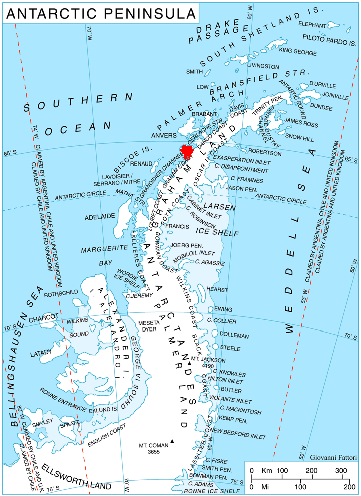
 Lemaire Channel is a
File:Lemaire Channel entry.jpg, In the north entry of Lemaire Channel looking south, from the deck of the ''Hanseatic''.
Image:Lemaire Channel Antarctica.jpg, Glaciers and cliffs reflected in still waters at the south end of the channel.
File:Cruise ship in Lemaire Channel.jpg, Russian cruise ship ''
SCAR Composite Gazetteer of Antarctica
{{coord, 65.133, S, 64.000, W, display=title, source:dewiki Straits of Antarctica Graham Coast Tourism sites in Antarctica
strait
A strait is an oceanic landform connecting two seas or two other large areas of water. The surface water generally flows at the same elevation on both sides and through the strait in either direction. Most commonly, it is a narrow ocean channe ...
off Antarctica, between Kyiv Peninsula
Kyiv Peninsula (, ) is the predominantly ice-covered, oval shaped peninsula projecting 35 km in northwest direction from the west side of Graham Land, Antarctic Peninsula. It is bounded by Flandres Bay to the northeast and Beascochea Bay to t ...
in the mainland's Graham Land and Booth Island
Booth Island (or Wandel Island) is a rugged, Y-shaped island, long and rising to off the northwest coast of Kyiv Peninsula in Graham Land, Antarctica in the northeastern part of the Wilhelm Archipelago. The narrow passage between the island a ...
. Nicknamed "Kodak Gap" by some, it is one of the top tourist destinations in Antarctica; steep cliffs hem in the iceberg
An iceberg is a piece of freshwater ice more than 15 m long that has broken off a glacier or an ice shelf and is floating freely in open (salt) water. Smaller chunks of floating glacially-derived ice are called "growlers" or "bergy bits". The ...
-filled passage, which is long and just wide at its narrowest point.
It was first seen by the German expedition of 1873-74, but not traversed until December 1898, when the ''Belgica
Gallia Belgica ("Belgic Gaul") was a Roman province, province of the Roman Empire located in the north-eastern part of Roman Gaul, in what is today primarily northern France, Belgium, and Luxembourg, along with parts of the Netherlands and German ...
'' of the Belgian Antarctic Expedition passed through. Expedition leader Adrien de Gerlache named it for Charles Lemaire (1863-1925), a Belgian explorer of the Congo.
The channel has since become a standard part of the itinerary for cruising in Antarctica; not only is it scenic, but the protected waters are usually as still as a lake, a rare occurrence in the storm-wracked southern seas, and the north-south traverse delivers vessels close to Petermann Island
Petermann Island is a small, low and rounded island, lying off the northwest coast of Kyiv Peninsula in Graham Land, Antarctica, a short distance south of Booth Island and the Lemaire Channel. It is a popular tourist destination.
Descriptio ...
for landings. The principal difficulty is that icebergs may fill the channel, especially in early season, obliging a ship to backtrack and go around the outside of Booth Island to reach Petermann.
Akademik Sergey Vavilov
The ''Akademik Sergey Vavilov'' (russian: Академик Сергей Вавилов) is a Russian (formerly Soviet) research vessel, named after physicist Sergey Vavilov. She was completed on 12 February 1988, at the Hollming Yard in Rauma, ...
'' in the Lemaire Channel
File:Unas_tits_2014.jpg
File:Icebergs_in_the_Lemaire_Channel,_Antarctica.jpg, Icebergs in the channel
See also
*Nimrod Passage Nimrod Passage () is a marine passage leading to the northern end of Lemaire Channel between Wauwermans Islands and Dannebrog Islands in Wilhelm Archipelago in Antarctica. The passage was surveyed by the Royal Navy Hydrographic Survey Unit
Royal ...
*Una Peaks
Una Peaks,John Splettstoesser (2009). Una Peaks: a long overdue Antarctic geographical naming. Polar Record, 45, pp 177-179. doi:10.1017/S0032247408008036abstract/ref> formerly known as Cape Renard Towers, are two towers of basalt, each topped by ...
References
SCAR Composite Gazetteer of Antarctica
{{coord, 65.133, S, 64.000, W, display=title, source:dewiki Straits of Antarctica Graham Coast Tourism sites in Antarctica