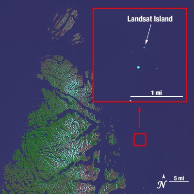
Landsat Island on:
[Wikipedia]
[Google]
[Amazon]
 Landsat Island is a small, uninhabited island located at approximately 60°10'37"N 64°02'30"W, off the northeast coast of
NASA article: Landsat Island
(April 19, 2006) * David H. Gray
"Discovering Rocks off Labrador: A Photo Essay"
''IBRU Boundary and Security Bulletin'', Summer 2000. {{coord, 60, 10, 37, N, 64, 2, 30, W, region:CA-NL_type:isle, display=title Uninhabited islands of Newfoundland and Labrador Landsat program 1976 in Newfoundland and Labrador Exploration of Canada
 Landsat Island is a small, uninhabited island located at approximately 60°10'37"N 64°02'30"W, off the northeast coast of
 Labrador
, nickname = "The Big Land"
, etymology =
, subdivision_type = Country
, subdivision_name = Canada
, subdivision_type1 = Province
, subdivision_name1 ...
(part of the Canadian
Canadians (french: Canadiens) are people identified with the country of Canada. This connection may be residential, legal, historical or cultural. For most Canadians, many (or all) of these connections exist and are collectively the source of ...
province of Newfoundland and Labrador
Newfoundland and Labrador (; french: Terre-Neuve-et-Labrador; frequently abbreviated as NL) is the easternmost province of Canada, in the country's Atlantic region. The province comprises the island of Newfoundland and the continental region ...
). It was discovered in 1976 during the analysis of imagery from the Landsat 1
Landsat 1 (LS-1), formerly named ERTS-A and ERTS-1, was the first satellite of the United States' Landsat program. It was a modified version of the Nimbus 4 meteorological satellite and was launched on July 23, 1972, by a Delta 900 rocket fr ...
satellite. The island is only , with a total area of .
Discovery
In 1976, a Canadian coastal survey was carried out using data from the Landsat 1 satellite. Analysis of the data revealed several previously uncharted features; this includes Landsat Island, which was subsequently named after the satellite. Verification of the island's existence fell to Dr. Frank Hall of theCanadian Hydrographic Service
''Retired Canadian Hydrographic Service logo or crest''
The Canadian Hydrographic Service (CHS) is part of the federal department of Fisheries and Oceans Canada and is Canada's authoritative hydrographic office. The CHS represents Canada in t ...
:
Following Dr. Hall's encounter with the polar bear, it was suggested that the island be named "Polar Island," but the present name was retained.
Landsat Island marks the easternmost point of the Canadian land mass along this section of the Labrador coast. As such, its discovery increased Canada's maritime territory by .
References
External links
NASA article: Landsat Island
(April 19, 2006) * David H. Gray
"Discovering Rocks off Labrador: A Photo Essay"
''IBRU Boundary and Security Bulletin'', Summer 2000. {{coord, 60, 10, 37, N, 64, 2, 30, W, region:CA-NL_type:isle, display=title Uninhabited islands of Newfoundland and Labrador Landsat program 1976 in Newfoundland and Labrador Exploration of Canada