Kingston, Glasgow on:
[Wikipedia]
[Google]
[Amazon]


 Kingston is an area of


 Kingston is an area of
 Glasgow
Glasgow ( ; sco, Glesca or ; gd, Glaschu ) is the most populous city in Scotland and the fourth-most populous city in the United Kingdom, as well as being the 27th largest city by population in Europe. In 2020, it had an estimated popul ...
, Scotland
Scotland (, ) is a country that is part of the United Kingdom. Covering the northern third of the island of Great Britain, mainland Scotland has a border with England to the southeast and is otherwise surrounded by the Atlantic Ocean to the ...
, from which the Kingston Bridge takes its name. Together with Ibrox, it forms one of the 56 neighbourhoods of Glasgow defined by Glasgow City Council
Glasgow City Council is the local government authority for the City of Glasgow, Scotland. It was created in 1996 under the Local Government etc. (Scotland) Act 1994, largely with the boundaries of the post-1975 City of Glasgow district of the S ...
for operational purposes. The area was assigned to Ward 54 until 2007 when it was reclassified as part of the Govan ward.
Geography
Kingston is bounded by theRiver Clyde
The River Clyde ( gd, Abhainn Chluaidh, , sco, Clyde Watter, or ) is a river that flows into the Firth of Clyde in Scotland. It is the ninth-longest river in the United Kingdom, and the third-longest in Scotland. It runs through the major cit ...
to the north; the Glasgow to Paisley railway line to the south; Kinning Park
Kinning Park is a southern suburb of Glasgow, Scotland. It was formerly a separate police burgh between 1871 and 1905 before being absorbed by the city. In 1897, it had a population of 14,326.Govan Parish School Board, ''The Members' Year Book 1 ...
(at Paisley Road Toll) to the west; and Tradeston
Tradeston () is a small district in the Scottish city of Glasgow adjacent to the city centre on the south bank of the River Clyde.
Geography
Tradeston is bounded by the River Clyde to the north, the Glasgow to Paisley railway line to the so ...
(at West Street) to the east. The M8 motorway and the M74 extension traverse the area.
To the west of the Kingston Bridge is now a mostly commercial area, which includes the Glasgow Quay leisure complex and the Kingston Bridge Trading Estate. To the east of the bridge, several modern residential apartment developments have been constructed including: the mixed residential and commercial development within the old Scottish Co-operative Wholesale Society
A co-operative wholesale society, or CWS, is a form of co-operative federation (that is, a co-operative in which all the members are co-operatives), in this case, the members are usually consumer cooperatives. According to co-operative economi ...
building, on Morrison Street; the Riverside apartments, built on what was formerly the Kingston Dock; and the Wallace Apartments, situated between Morrison Street and Wallace Street. Still further east is the smaller district of Tradeston
Tradeston () is a small district in the Scottish city of Glasgow adjacent to the city centre on the south bank of the River Clyde.
Geography
Tradeston is bounded by the River Clyde to the north, the Glasgow to Paisley railway line to the so ...
, which adjoins Kingston on its boundary at West Street.
Notable Kingston buildings
* Scotland Street School Museum, within the school building designed byCharles Rennie Mackintosh
Charles Rennie Mackintosh (7 June 1868 – 10 December 1928) was a Scottish architect, designer, water colourist and artist. His artistic approach had much in common with European Symbolism. His work, alongside that of his wife Margaret Macdo ...
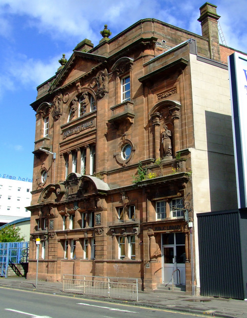
* Kingston Halls, attributed to the architect Robert William Horn (1869-1932); it incorporated the first Carnegie funded library to be opened in the city
* Scottish Co-operative Wholesale Society Building - 1886-93, Bruce & Hay
Transport
Kingston has access to two stations on theGlasgow Subway
The Glasgow Subway is an underground light metro system in Glasgow, Scotland. Opened on 14 December 1896, it is the fourth-oldest underground rail transit system in Europe after the London Underground, Liverpool's Mersey Railway and the Budapes ...
system: Shields Road, which also serves Pollokshields
Pollokshields ( gd, Buthan Phollaig, Scots: ''Powkshiels'') is an area in the Southside of Glasgow, Scotland. Its modern boundaries are largely man-made, being formed by the M77 motorway to the west and northwest with the open land of Pollok C ...
; and West Street
The Joe DiMaggio Highway, commonly called the West Side Highway and formerly the Miller Highway, is a mostly surface section of New York State Route 9A (NY 9A), running from West 72nd Street along the Hudson River to the southern t ...
, in neighbouring Tradeston. There are also frequent bus services along Paisley Road West.
Recreation
The Glasgow Quay area, developed on Springfield Quay, has in recent years become a major entertainment and leisure hub with bowling, casino, cinema and a variety of bars & restaurants.References
Further reading
*External links
* (Map showing Kingston in the bottom right of the map when zoomed several levels) {{Areas of Glasgow Areas of Glasgow Business parks of Scotland