Khuzestan Plain on:
[Wikipedia]
[Google]
[Amazon]
The Khuzestan Plain is the relatively flat region of
 In the 19th and early 20th centuries, the
Iran
Iran, officially the Islamic Republic of Iran, and also called Persia, is a country located in Western Asia. It is bordered by Iraq and Turkey to the west, by Azerbaijan and Armenia to the northwest, by the Caspian Sea and Turkmeni ...
where the Khuzestan
Khuzestan Province (also spelled Xuzestan; fa, استان خوزستان ''Ostān-e Xūzestān'') is one of the 31 provinces of Iran. It is in the southwest of the country, bordering Iraq and the Persian Gulf. Its capital is Ahvaz and it cover ...
province and the cities of Ahvaz
Ahvaz ( fa, اهواز, Ahvâz ) is a city in the southwest of Iran and the capital of Khuzestan province. Ahvaz's population is about 1,300,000 and its built-up area with the nearby town of Sheybani is home to 1,136,989 inhabitants. It is hom ...
, Susa
Susa ( ; Middle elx, 𒀸𒋗𒊺𒂗, translit=Šušen; Middle and Neo- elx, 𒋢𒋢𒌦, translit=Šušun; Neo- Elamite and Achaemenid elx, 𒀸𒋗𒐼𒀭, translit=Šušán; Achaemenid elx, 𒀸𒋗𒐼, translit=Šušá; fa, شوش ...
and Abadan
Abadan ( fa, آبادان ''Ābādān'', ) is a city and capital of Abadan County, Khuzestan Province, which is located in the southwest of Iran. It lies on Abadan Island ( long, 3–19 km or 2–12 miles wide). The island is bounde ...
are located. It is the largest plain in Iran and one of the richest agricultural areas in the world. It is irrigated by several big rivers such as Karun
The Karun ( fa, کارون, ) is the Iranian river with the highest water flow, and its only navigable river. It is long. It rises in the Zard Kuh mountains of the Bakhtiari district in the Zagros Range, receiving many tributaries, such as t ...
and Karkheh
The Karkheh or Karkhen کرخه (perhaps the river known as the Gihon—one of the four rivers of Eden/Paradise to the Bible and as the Choaspes in ancient times; also called Eulæus; Hebrew: אולי Ulai) is a river in Khūzestān Province, ...
. Khuzestan Plain borders Mesopotamia
Mesopotamia ''Mesopotamíā''; ar, بِلَاد ٱلرَّافِدَيْن or ; syc, ܐܪܡ ܢܗܪ̈ܝܢ, or , ) is a historical region of Western Asia situated within the Tigris–Euphrates river system, in the northern part of the ...
and is separated from it by the Shatt al-Arab
The Shatt al-Arab ( ar, شط العرب, lit=River of the Arabs; fa, اروندرود, Arvand Rud, lit=Swift River) is a river of some in length that is formed at the confluence of the Euphrates and Tigris rivers in the town of al-Qurnah in ...
(known as Arvand Rud in Iran) river.
Khuzestan was the center of the ancient Elamite culture of Iran.
Wildlife
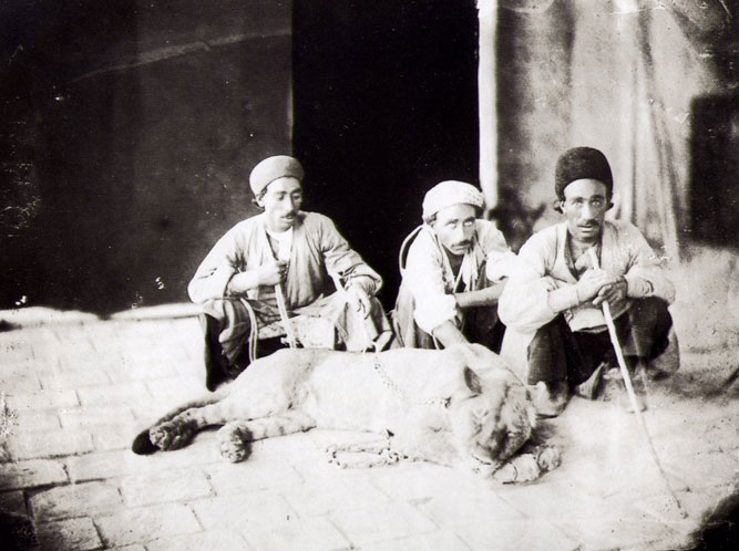
 In the 19th and early 20th centuries, the
 Asiatic lion
The Asiatic lion is a population of '' Panthera leo leo'' that today survives in the wild only in India. Since the turn of the 20th century, its range has been restricted to Gir National Park and the surrounding areas in the Indian state of Gujar ...
was recorded in Fars Province, Ramhormoz County, Shushtar County, Dezful County
Dezful County ( fa, شهرستان دزفول) is located in Khuzestan province, Iran. The capital of the county is Dezful
Dezful ( fa, دزفول, pronounced , Dezfuli dialect: Desfil, pronounced ) also Romanized as Dezfūl and Dezfool; also ...
and along the Karun
The Karun ( fa, کارون, ) is the Iranian river with the highest water flow, and its only navigable river. It is long. It rises in the Zard Kuh mountains of the Bakhtiari district in the Zagros Range, receiving many tributaries, such as t ...
river.
See also
*Tidal irrigation
Tidal irrigation is the subsurface irrigation of levee soils in coastal plains with river water under tidal influence. It is applied in (semi) arid zones at the mouth of a large river estuary or delta where a considerable tidal range (some 2 ...
References
Landforms of Khuzestan Province Plains of Iran {{Khuzestan-geo-stub