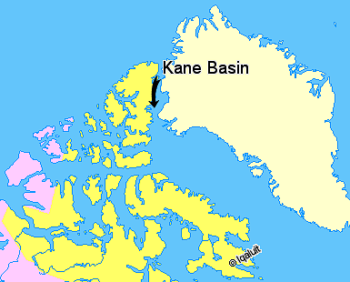
Kane Basin on:
[Wikipedia]
[Google]
[Amazon]
 Kane Basin ( da, Kane Bassin; french: Bassin (de) Kane) is an Arctic waterway lying between Greenland and Canada's northernmost island,
 McGary Oer, Greenland
/ref>
 Kane Basin ( da, Kane Bassin; french: Bassin (de) Kane) is an Arctic waterway lying between Greenland and Canada's northernmost island,
 Ellesmere Island
Ellesmere Island ( iu, script=Latn, Umingmak Nuna, lit=land of muskoxen; french: île d'Ellesmere) is Canada's northernmost and List of Canadian islands by area, third largest island, and the List of islands by area, tenth largest in the world. ...
. It links Smith Sound
Smith Sound ( da, Smith Sund; french: Détroit de Smith) is an uninhabited Arctic sea passage between Greenland and Canada's northernmost island, Ellesmere Island. It links Baffin Bay with Kane Basin and forms part of the Nares Strait.
On the ...
to Kennedy Channel and forms part of Nares Strait. It is approximately 180 kilometres in length and 130 km at its widest.
It is named after the American explorer Elisha Kane, whose expedition in search of Franklin's lost expedition crossed it in 1854. Kane himself had named it "Peabody Bay," in honor of philanthropist George Peabody, the major funder of Kane's expedition. Currently Peabody Bay is a bay at the eastern side of the basin, off the southwestern end of the Humboldt Glacier in northern Greenland./ref>
Further reading
* Cold Regions Research and Engineering Laboratory (U.S.). ''Radar Imagery of Arctic Pack Ice Kane Basin to North Pole''. Hanover, N.H.: The Division, 1968. * Hobbs, William Herbert. ''Discovery and Exploration Within the Area to the West of the Kane Basin''. 1939. * Kravitz, Joseph. ''Sediments and Sediment Processes in Kane Basin, a High Arctic Glacial Marine Basin''. oulder, Colo.? University of Colorado, Institute of Arctic and Alpine Research, 1982. * Marentette, Kris Allen. ''Late Quaternary Paleoceanography in Kane Basin, Canada and Greenland''. Ottawa: National Library of Canada, 1989.References
Seas of Greenland Bays of Qikiqtaaluk Region Canada–Greenland border International straits Straits of Canada {{Greenland-geo-stub