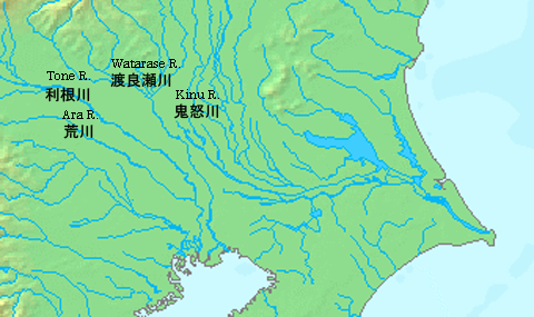
Katori Sea on:
[Wikipedia]
[Google]
[Amazon]

 The refers to the vanished inland sea formerly located in the eastern part of the ancient

 The refers to the vanished inland sea formerly located in the eastern part of the ancient
 Kantō Plain
The is the largest plain in Japan, and is located in the Kantō region of central Honshū. The total area of 17,000 km2 covers more than half of the region extending over Tokyo, Saitama Prefecture, Kanagawa Prefecture, Chiba Prefecture, ...
connected to the Pacific Ocean
The Pacific Ocean is the largest and deepest of Earth's five oceanic divisions. It extends from the Arctic Ocean in the north to the Southern Ocean (or, depending on definition, to Antarctica) in the south, and is bounded by the contin ...
, between the prefectures of Ibaraki and Chiba in Japan.
Inland sea
In the Jōmon period part of theKantō Plain
The is the largest plain in Japan, and is located in the Kantō region of central Honshū. The total area of 17,000 km2 covers more than half of the region extending over Tokyo, Saitama Prefecture, Kanagawa Prefecture, Chiba Prefecture, ...
was covered by the sea, due to the Holocene glacial retreat
The Holocene glacial retreat is a geographical phenomenon that involved the global retreat of glaciers (deglaciation) that previously had advanced during the Last Glacial Maximum. Ice sheet retreat initiated ca. 19,000 years ago and accelerated ...
, which peaked about 6,000 years ago.
After thousands of years the land rose and the sea receded, and in the Yayoi period
The started at the beginning of the Neolithic in Japan, continued through the Bronze Age, and towards its end crossed into the Iron Age.
Since the 1980s, scholars have argued that a period previously classified as a transition from the Jōmon ...
and the Kofun period much of the area was covered by wetlands, lakes and lagoons.
Over the centuries the sea decreased in size, a further cause of which was the deposition of volcanic ash from the nearby mountains and around Kantō. The volcanic ash fell in great quantity, and was also carried by the wind, by the rain, spilled into the rivers, from where it reached the Katori Sea and the Pacific Ocean. Additionally the sediments and rocks that flowed in the rivers influenced the decrease in size of the Katori.
Later the Lake Kasumigaura
is the second-largest lake in Japan, located 60 km to the north-east of Tokyo.
In a narrower sense and officially, Lake Kasumigaura refers to a waterbody with an area of 167.63 km2. In a wider sense, Lake Kasumigaura can also refer t ...
was formed from the remains of the inland sea.
Edo Period
During theTokugawa Shogunate
The Tokugawa shogunate (, Japanese 徳川幕府 ''Tokugawa bakufu''), also known as the , was the military government of Japan during the Edo period from 1603 to 1868. Nussbaum, Louis-Frédéric. (2005)"''Tokugawa-jidai''"in ''Japan Encyclopedia ...
in the Edo period
The or is the period between 1603 and 1867 in the history of Japan, when Japan was under the rule of the Tokugawa shogunate and the country's 300 regional '' daimyo''. Emerging from the chaos of the Sengoku period, the Edo period was characte ...
, because of the food situation in Edo City, the recovery and development of the flooded lands and the sea became necessary, so the Tone River
The is a river in the Kantō region of Japan. It is in length (the second longest in Japan after the Shinano) and has a drainage area of (the largest in Japan). It is nicknamed Bandō Tarō (); ''Bandō'' is an obsolete alias of the Kantō ...
project was carried out. The Tone River originally discharged into the Tokyo Bay, but was diverted to flow into the Pacific Ocean (Kashima-nada); the courses of the rivers in this area were adequate to channel any overflow and avoid large floods. Lake Katori disappeared, and the desalination began of the lakes and lagoons that it left behind. The project encouraged canal farming, and irrigation was actively developed.
Present
The remains of the inland sea are present in the Nishiura, Kitaura and Sotonasakaura lakes of the Kasumigaura and in the Teganuma and Inbanuma lagoons.See also
Suigō-Tsukuba Quasi-National ParkReferences
{{ReflistExternal links
*this article contains information from the existing Japanese Wikipedia article at 香取海 (Katori Sea) and 縄文海進 (Jōmon Kaishin). Landforms of Ibaraki Prefecture Landforms of Chiba Prefecture