Jogulamba Gadwal on:
[Wikipedia]
[Google]
[Amazon]
Jogulamba district is a district in the
 The district has one
Indian state
India is a federal union comprising 28 states and 8 union territories, with a total of 36 entities. The states and union territories are further subdivided into districts and smaller administrative divisions.
History
Pre-indepen ...
of Telangana
Telangana (; , ) is a States and union territories of India, state in India situated on the south-central stretch of the Indian subcontinent, Indian peninsula on the high Deccan Plateau. It is the List of states and union territories of India b ...
. The administrative headquarters of the district is located at Gadwal
Gadwal is a City and the district headquarters of Jogulamba Gadwal district in the Indian state of Telangana. It is located from the state capital Hyderabad And 59 km From Kurnool and is a state assembly constituency. Gadwal historicall ...
. The district shares boundaries with Narayanpet, Wanaparthy
Wanaparthy is a town of Wanaparthy district of Telangana, India. The first polytechnic college (KDR Government Polytechnic) in Telangana started in Wanaparthy. It is located 149 km from the state capital Hyderabad.
History
Wanaparthy was ...
districts and with the state boundary of Andhra Pradesh
Andhra Pradesh (, abbr. AP) is a state in the south-eastern coastal region of India. It is the seventh-largest state by area covering an area of and tenth-most populous state with 49,386,799 inhabitants. It is bordered by Telangana to the ...
and Karnataka
Karnataka (; ISO: , , also known as Karunāḍu) is a state in the southwestern region of India. It was formed on 1 November 1956, with the passage of the States Reorganisation Act. Originally known as Mysore State , it was renamed ''Karnat ...
. The district was carved out from Mahabubnagar district
Mahabubnagar district is a district in the Indian state of Telangana. Mahabubnagar is the district headquarters which is popularly known as Palamoor. The district shares boundaries with Narayanapet, Vikarabad, Rangareddy, Nagarkurnool, Wanapa ...
in 2016.
The district is spread over an area of . the 2011 Census of India
The 2011 Census of India or the 15th Indian Census was conducted in two phases, house listing and population enumeration. The House listing phase began on 1 April 2010 and involved the collection of information about all buildings. Information ...
, the area within the district had a population of 609,990.
Administrative divisions
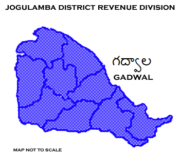
 The district has one
 revenue division
A Revenue division is an administrative division of some of the States and union territories of India, Indian states. It is a geographic area covering many tehsils, which in turn comprises villages. A revenue division is headed by a Revenue Divisio ...
, Gadwal, and is sub-divided into 12 mandals.
Mandals
Demographics
The district has a population of 6,09,990 of which 3,09,274 are males and 3,00,716 females. Urban population is 63,177 (10.36%). Scheduled Castes and Scheduled Tribes made up 120,639 (19.77%) and 9376 (1.54%) of the population respectively. At the time of the 2011 census, 90.09% of the population spokeTelugu
Telugu may refer to:
* Telugu language, a major Dravidian language of India
*Telugu people, an ethno-linguistic group of India
* Telugu script, used to write the Telugu language
** Telugu (Unicode block), a block of Telugu characters in Unicode
S ...
and 7.49% Urdu
Urdu (;"Urdu"
''
Official website
{{coord missing, Telangana Districts of Telangana Jogulamba Gadwal district Mandals in Jogulamba Gadwal district
''
See also
*List of districts in Telangana
The Indian state of Telangana has 33 districts, each headed by a District collector.
History
Telangana region of Hyderabad State consisted of 8 Districts in 1948 when it was inducted in Dominion of India; they are Hyderabad, Mahbubnagar ...
References
External links
Official website
{{coord missing, Telangana Districts of Telangana Jogulamba Gadwal district Mandals in Jogulamba Gadwal district