Janapar on:
[Wikipedia]
[Google]
[Amazon]

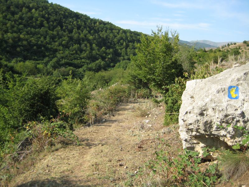
 Janapar Trail () is a marked trail through mountains, valleys, and villages of the self-proclaimed Republic of Artsakh which passes by monasteries and fortresses along its route. The trail consists of several day hikes, taking hikers to a different village each night. Hikers could either stay with a village family or set up camp nearby. The paths have existed for centuries but markings were added in recent years specifically for hikers Provided markers are blue with a yellow footprint. According to the trail's official website, much of the trail became unhikable as a result of the
File:2014 Górski Karabach, Widoki ze szlaku turystycznego Dżanapar (45).jpg, The views from the Janapar tourist route. Section between the cities Shusha and Stepanakert
File:2014 Górski Karabach, Widoki ze szlaku turystycznego Dżanapar (02).jpg, The view from the Janapar tourist route. Section between
נגורנו קראבאך: מסע בארץ מצולקת
Official site
{{Coord missing, Armenia Hiking trails in Europe Tourist attractions in the Republic of Artsakh Tourist attractions in Azerbaijan
2020 Nagorno-Karabakh war
The Second Nagorno-Karabakh War was an armed conflict in 2020 that took place in the disputed region of Nagorno-Karabakh and Armenian-occupied territories surrounding Nagorno-Karabakh, the surrounding territories. It was a major escalation of ...
, with only the Stepanakert
/ az, Xankəndi, italic=no
, settlement_type = City
, image_skyline = File:StepanakertCollage.jpg
, imagesize = 300px
, image_caption = From top left: Holy Mother ...
to Patara and Kolotak to Gandzasar sections remaining traversable.
Janapar Trail Route
The Janapar Trail, marked in 2007, led from the southern town ofHadrut
Hadrut ( hy, Հադրութ, ) is a town in the Khojavend District of Azerbaijan, in the disputed region of Nagorno-Karabakh.
The town had an ethnic Armenian-majority population prior to the 2020 Nagorno-Karabakh war. Numerous Armenian civilians ...
to the capital of Stepanakert
/ az, Xankəndi, italic=no
, settlement_type = City
, image_skyline = File:StepanakertCollage.jpg
, imagesize = 300px
, image_caption = From top left: Holy Mother ...
over the course of a week. From there the trail continues north to the region of Shahumian, and on to Vardenis in Armenia. Important sites along this hike include Dadivank monastery, Gandzasar monastery, Shusha, the Karkar Canyon with its high cliffs, the astonishing Zontik Waterfall and ruins of Hunot, as well as the 2,000-year-old tree, called Tnjri, Azykh Cave and Gtichavank
Gtichavank ( hy, Գտչավանք; az, Ktişvəng or ) is a 13th-century Armenian Apostolic Christopher J. Walker. Armenia and Karabagh: The Struggle for Unity. — Minority Rights Group, 1991. — P. 78. monastery, located near the village of T ...
monastery. There are also hot springs in Zar, a geyser near Karvarchar city, and other springs and waterfalls along the way.
TIn 2018 Trails For Change NGO repainted the blazing on the entire trail. The trail creators advise hikers to use the Viewranger app or a GPS with the downloaded tracks, or the topographic maps made available on the Janapar website.
Janapar symbol
The symbol of the trail is a footprint with the silhouette of Nagorno-Karabakh, which is composed of a single wandering line, which represents a hiking trail.Gallery
Photos from along the JanaparKarintak
Dashalty ( az, Daşaltı) or Karin Tak ( hy, Քարին Տակ) is a village in the Shusha District of Azerbaijan, in the disputed region of Nagorno-Karabakh. The village had an ethnic Armenian-majority population prior to the 2020 Nagorno-Karaba ...
village and the city of Shusha
File:2014 Szuszi, Meczet Ashaghi Govhar Agha (02).jpg, Minarets of Ashaghi Govhar Agha Mosque in Shusha
File:Ghazanchetsots Double Rainbow.jpg, Cathedral of Shusha
File:Vodopád, Náhorní Karabach.jpg, Zontik Waterfall in Gargarchay (Karkar) Canyon
File:Kaňon řeky Karkar, Náhorní Karabach.jpg, Gargarchay (Karkar) Canyon
File:Дадиванк.jpg, Dadivank Monastery
File:Gandzasar Monastery1.jpg, Gandzasar Monastery
File:Skthorashen-old-tree.jpeg, 2,000 year old Tnjri tree
File:Azokh Cave3.jpg, Azykh Cave
File:Gtichavank.jpg, Gtichavank (old photo)
File:Karmir-shuka.jpeg, Fields near Karmir Shuka
References
Sources
*Destination Janapar - Yerevan Magazine, May–June 2013 *Le Janapar Trail - Nouvelle d'Arménie, April 2013 (No. 195, pp. 68–73)נגורנו קראבאך: מסע בארץ מצולקת
External links
Official site
{{Coord missing, Armenia Hiking trails in Europe Tourist attractions in the Republic of Artsakh Tourist attractions in Azerbaijan