Iwate District, Iwate on:
[Wikipedia]
[Google]
[Amazon]
 is a
is a
 Iwate District was the northernmost of the six districts of northern Mutsu Province (六奥郡)created in the early

 is a
is a rural district
Rural districts were a type of local government area – now superseded – established at the end of the 19th century in England, Wales, and Ireland for the administration of predominantly rural areas at a level lower than that of the Ad ...
located in Iwate Prefecture
is a prefecture of Japan located in the Tōhoku region of Honshu. It is the second-largest Japanese prefecture at , with a population of 1,210,534 (as of October 1, 2020). Iwate Prefecture borders Aomori Prefecture to the north, Akita Prefectur ...
, Japan
Japan ( ja, 日本, or , and formally , ''Nihonkoku'') is an island country in East Asia. It is situated in the northwest Pacific Ocean, and is bordered on the west by the Sea of Japan, while extending from the Sea of Okhotsk in the north ...
.
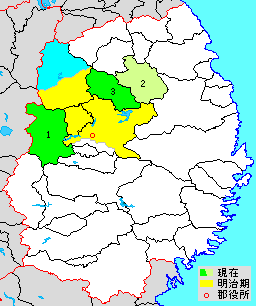
As of June 1, 2019, the district has an estimated population of 34,416 with a density of 24.5 per km2 and an area of 1404.24 km2. The entire city of Takizawa, the southern half of the city of Hachimantai and most of the city of Morioka
is the capital city of Iwate Prefecture located in the Tōhoku region of northern Japan. On 1 February 2021, the city had an estimated population of 290,700 in 132,719 households, and a population density of . The total area of the city is .
...
were formerly part of Iwate District.
Towns and villages
The district consists of three towns: * Iwate * Kuzumaki *Shizukuishi
is a town located in Iwate Prefecture, Japan. , the town had an estimated population of 16,263 in 6354 households, and a population density of 27 persons per km². The total area of the town is .
Geography
Shizukuishi is located in the Ōu M ...
History
Under Mutsu Province
 Iwate District was the northernmost of the six districts of northern Mutsu Province (六奥郡)created in the early
 Heian period
The is the last division of classical Japanese history, running from 794 to 1185. It followed the Nara period, beginning when the 50th emperor, Emperor Kanmu, moved the capital of Japan to Heian-kyō (modern Kyoto). means "peace" in Japanese. ...
after the conquest of the Kitakami River
The is the fourth largest river in Japan and the largest in the Tōhoku region. It is long and drains an area of . page 793 It flows through mostly rural areas of Iwate and Miyagi Prefectures. The source of the river is the Mount Nanashirug ...
Valley from the Emishi
The (also called Ebisu and Ezo), written with Chinese characters that literally mean "shrimp barbarians," constituted an ancient ethnic group of people who lived in parts of Honshū, especially in the Tōhoku region, referred to as in contemp ...
tribes by the Japanese army led by General Sakanoue no Tamuramaro
was a court noble, general and ''shōgun'' of the early Heian period of Japan. He served as Dainagon, Minister of War and ''Ukon'e no Taisho'' (Major Captain of the Right Division of Inner Palace Guards). He held the '' kabane'' of Ōsukune ...
. The districts were named by Emperor Heizei
, also known as ''Heijō-tennō'', was the 51st emperor of Japan, Emperor Heizei, Yamamomo Imperial Mausoleum, Imperial Household Agency according to the traditional order of succession. Heizei's reign lasted from 806 to 809.
Traditional narr ...
, and the name of “Iwate” was originally written with the ''kanji
are the logographic Chinese characters taken from the Chinese family of scripts, Chinese script and used in the writing of Japanese language, Japanese. They were made a major part of the Japanese writing system during the time of Old Japanese ...
'' 磐手, and appears in this form in the ''Yamato Monogatari
is a collection of 173 short stories which give details about life in the imperial court in the 9th and 10th centuries. Nussbaum, Louis-Frédéric. (2005)"''Yamato monogatari''"in ''Japan Encyclopedia'', p. 1047.
It is an ''uta monogatari'' (a w ...
'', compiled in the year 951. By the middle Heian period, the ''kanji'' had changed to its present form, although it was also occasionally referred to as ‘''Iwadenomori (岩出の森郡)
Iwate District was the northern frontier of Japan until the Enkyu-Emishi War of 1070, which extended the frontier to the northern coast of Honshu. As with the rest of the region, the early history of Iwate District is uncertain. Although Shiwa Castle
was an early Heian period ''jōsaku''-style Japanese castle located in what is now part of the city of Morioka, Iwate Prefecture in the Tōhoku region of far northern Honshu, Japan. The site was proclaimed a Monuments of Japan, National Historic S ...
was constructed in 803 as a major army base in the region, it fell into ruins only ten years later. The area came to be ruled by the Abe clan
The was one of the oldest of the major Japanese clans (''uji''); and the clan retained its prominence during the Sengoku period and the Edo period.Meyer, Eva-Maria"Gouverneure von Kyôto in der Edo-Zeit." Universität Tübingen (in German). The ...
until the Former Nine Years War (1051-1063), followed by the Kiyohara clan
The was a powerful clan of the far north of Japan during the Heian period, descended from Prince Toneri, son of Emperor Tenmu (631–686).
Kiyohara no Fusanori (9th century) had two sons: the elder was the ancestor of the samurai branch fam ...
until the Gosannen War
The Gosannen War (後三年合戦, ''gosannen kassen''), also known as the Later Three-Year War, was fought in the late 1080s in Japan's Mutsu Province on the island of Honshū.
History
The Gosannen War was part of a long struggle for power wi ...
(1083-1089) and the Northern Fujiwara
The Northern Fujiwara (奥州藤原氏 ''Ōshū Fujiwara-shi'') were a Japanese noble family that ruled the Tōhoku region (the northeast of Honshū) of Japan during the 12th century as their own realm.
until 1189. During the Muromachi period
The is a division of Japanese history running from approximately 1336 to 1573. The period marks the governance of the Muromachi or Ashikaga shogunate (''Muromachi bakufu'' or ''Ashikaga bakufu''), which was officially established in 1338 by t ...
, the area gradually came under the control of the Nanbu clan
The was a Japanese samurai clan who ruled most of northeastern Honshū in the Tōhoku region of Japan for over 700 years, from the Kamakura period through the Meiji Restoration of 1868. The Nanbu claimed descent from the Seiwa Genji of Kai P ...
from Nukanobu District to the north.
Under the Tokugawa shogunate
The Tokugawa shogunate (, Japanese 徳川幕府 ''Tokugawa bakufu''), also known as the , was the military government of Japan during the Edo period from 1603 to 1868. Nussbaum, Louis-Frédéric. (2005)"''Tokugawa-jidai''"in ''Japan Encyclopedia ...
, Iwate county consisted of one town (Morioka) and 85 villages under the control of Morioka Domain
300px, Ruins of Morioka Castle
was a '' tozama'' feudal domain of Edo period Japan. It was ruled throughout its history by the Nanbu clan. It was called during the early part of its history. It was located in northern Mutsu Province, Honshū, ...
.
Early Meiji period
Following theMeiji restoration
The , referred to at the time as the , and also known as the Meiji Renovation, Revolution, Regeneration, Reform, or Renewal, was a political event that restored practical imperial rule to Japan in 1868 under Emperor Meiji. Although there were ...
, Iwate District came under Rikuchū Province
was an old province in the area of Iwate and Akita Prefectures. Nussbaum, Louis-Frédéric. (2005). "''Rikuchū''" in . It was sometimes called , with Rikuzen and Mutsu Provinces.
Rikuchu covered most of modern-day Iwate Prefecture: with th ...
and became part of Morioka Prefecture in 1871. Morioka Prefecture became Iwate Prefecture in 1872. In January 1879, Iwate District was divided into Kita-Iwate District with 47 villages, and Minimi-Iwate District with 38 villages.

Subsequent timeline
*April 1, 1897 – With the establishment of the municipality system, Kita-Iwate District and Minami-Iwate District were merged to become Iwate District, and was organized into one town (Morioka
is the capital city of Iwate Prefecture located in the Tōhoku region of northern Japan. On 1 February 2021, the city had an estimated population of 290,700 in 132,719 households, and a population density of . The total area of the city is .
...
and 24 villages)
*December 23, 1940 - The village of Shizukuishi was elevated to town status. (2 towns, 21 villages)
*April 10, 1941 - The villages of Asagishi, Nakano and Motomiya were merged into the city of Morioka. (2 towns, 18 villages)
*July 1, 1948 - The town of Kuzumaki, and the village of Ekari were moved from Kunohe District to Iwate District. (3 towns, 19 villages)
*April 1, 2002 - The town of Ashiro was moved from Ninohe District to Iwate District. (5 towns, 3 villages)
*September 1, 2005 - The towns of Ashiro and Nishine, and the village of Matsuo Matsuo may refer to:
Places
* Matsuo, Chiba
* Matsuo, Iwate
*Mount Matsuo
*Matsuo Station (disambiguation)
* Siege of Matsuo
*Matsuo mine
, was an iron and sulphur mine located in the village of Matsuo, Iwate Prefecture in the Tohoku region of n ...
were merged to create the city of Hachimantai. (3 towns, 2 villages)
*January 10, 2006 - The village of Tamayama was merged into the expanded city of Morioka. (3 towns, 1 village)
*January 1, 2014 - The village of Takizawa was elevated to city status. (3 towns)
{{Authority control
Districts in Iwate Prefecture