Inter-Entity Boundary Line on:
[Wikipedia]
[Google]
[Amazon]

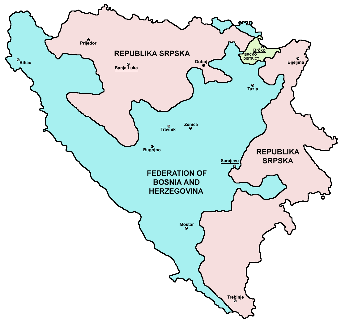
 The Inter-Entity Boundary Line ( sh, Međuentitetska linija), commonly abbreviated IEBL, is the administrative line that subdivides
At the time of the creation of the Dayton Accord, Brčko was also divided between FBiH and RS. Lately, however, the city was re-consolidated as the
Excerpts from Remarks by Admiral Leighton W. Smith to the North Atlantic Council
A precarious peace
Bosnia: a single country or an apple of discord?
Bosnian Institute, 12 May 2006 {{Borders of Bosnia and Herzegovina * Law of Bosnia and Herzegovina Federation of Bosnia and Herzegovina Republika Srpska

Bosnia and Herzegovina
Bosnia and Herzegovina ( sh, / , ), abbreviated BiH () or B&H, sometimes called Bosnia–Herzegovina and often known informally as Bosnia, is a country at the crossroads of south and southeast Europe, located in the Balkans. Bosnia and H ...
into two entities, ''Republika Srpska
Republika Srpska ( sr-Cyrl, Република Српска, lit=Serb Republic, also known as Republic of Srpska, ) is one of the two entities of Bosnia and Herzegovina, the other being the Federation of Bosnia and Herzegovina. It is locat ...
'' and the Federation of Bosnia and Herzegovina. The total length of the Inter-Entity Boundary Line is .
History
The presentpolitical divisions of Bosnia and Herzegovina
The political divisions of Bosnia and Herzegovina were created by the Dayton Agreement. The Agreement divides the country into two federal entities: the Federation of Bosnia and Herzegovina (FBiH) and the Republika Srpska (RS) and one additio ...
is based on ''Annex 4'' of the ''General Framework Agreement for Peace'', also known as Dayton Agreement
The General Framework Agreement for Peace in Bosnia and Herzegovina, also known as the Dayton Agreement or the Dayton Accords ( Croatian: ''Daytonski sporazum'', Serbian and Bosnian: ''Dejtonski mirovni sporazum'' / Дејтонски миро ...
, concluded at the Dayton Peace Conference in November 1995, and subsequently signed in Paris
Paris () is the Capital city, capital and List of communes in France with over 20,000 inhabitants, most populous city of France, with an estimated population of 2,165,423 residents in 2019 in an area of more than 105 km² (41 sq mi), ma ...
on December 14, 1995. A key component of this was the delineation of the Inter-Entity Boundary Line (IEBL), to which many of the tasks listed in the other Annexes referred.
In particular the IEBL affected the tasks of the ''Military Annexes'', such as the initial and immediate ''"Separation of Forces"'', the creation of an initial ''"Zone of Separation"'', the ''"Transfer of Areas"'' between the entities and the district, and the ''"Removal of Forces"'' to ''"Containment Areas"''.
During this initial ''"Implementation Period"'', enforced by NATO
The North Atlantic Treaty Organization (NATO, ; french: Organisation du traité de l'Atlantique nord, ), also called the North Atlantic Alliance, is an intergovernmental military alliance between 30 member states – 28 European and two No ...
-led ''Implementation Force'' or IFOR
The Implementation Force (IFOR) was a NATO-led multinational peace enforcement force in Bosnia and Herzegovina under a one-year mandate from 20 December 1995 to 20 December 1996 under the codename ''Operation Joint Endeavour''.
Background
NATO ...
, it was required that along the IEBL a so-called 2 km ''"Zone of Separation"'' be established, which stretched toward both entities, making a zone 4 km wide in total.
The IEBL mostly follows along the military front-lines as they were at the end of the Bosnian War (with some major adjustments, most notably in the western part of the country, and in-and-around Sarajevo
Sarajevo ( ; cyrl, Сарајево, ; ''see names in other languages'') is the capital and largest city of Bosnia and Herzegovina, with a population of 275,524 in its administrative limits. The Sarajevo metropolitan area including Sarajevo ...
).
The IEBL between Republika Srpska
Republika Srpska ( sr-Cyrl, Република Српска, lit=Serb Republic, also known as Republic of Srpska, ) is one of the two entities of Bosnia and Herzegovina, the other being the Federation of Bosnia and Herzegovina. It is locat ...
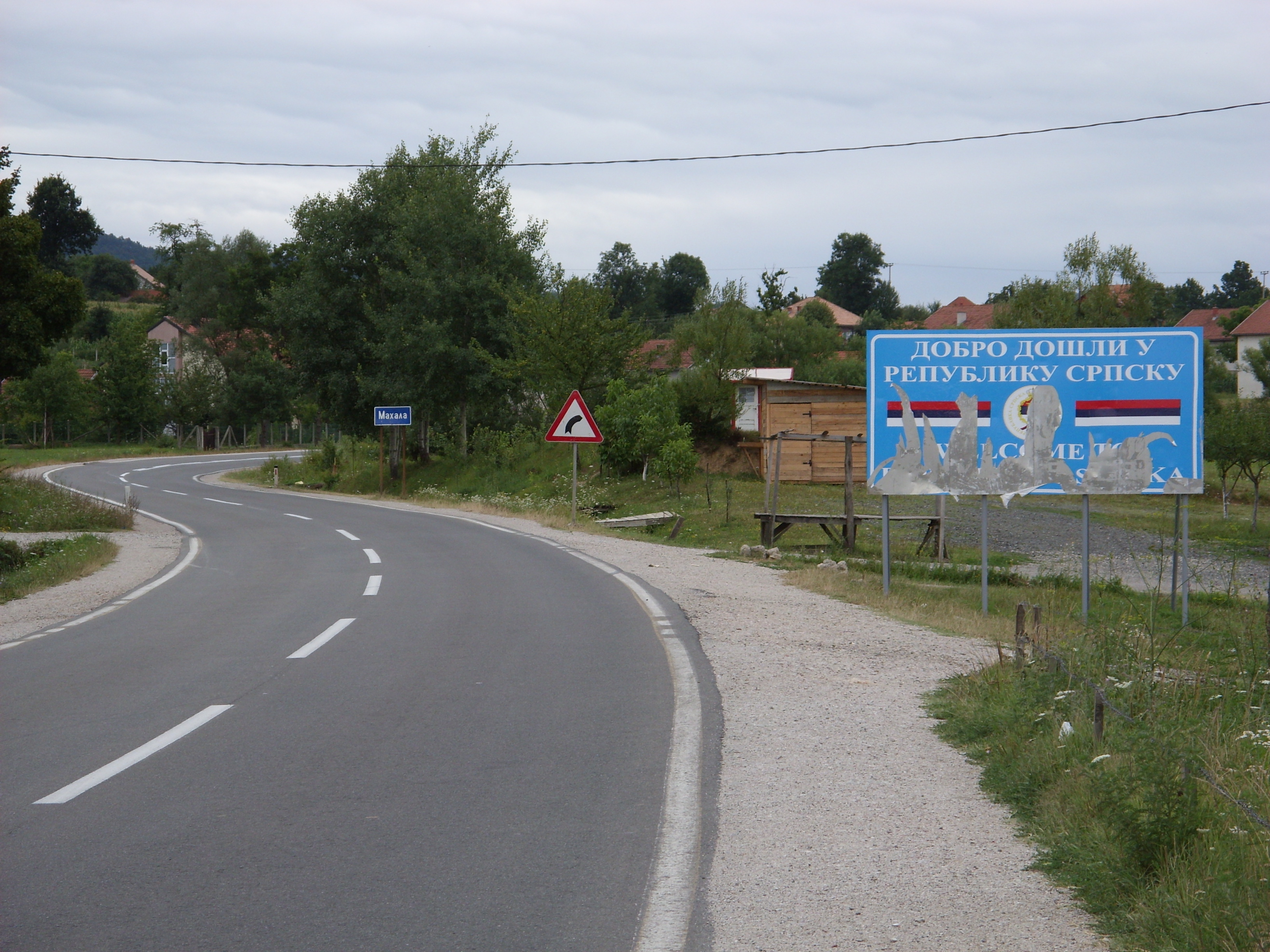
, the Federation of Bosnia and Herzegovina and the Brčko District is no longer controlled by the military and is not policed. ''"Zone of Separation"'' is no longer in effect. There are no border controls and crossings of any kind.
Mapping technology
Dayton marked the first occasion when three-dimensionalsatellite
A satellite or artificial satellite is an object intentionally placed into orbit in outer space. Except for passive satellites, most satellites have an electricity generation system for equipment on board, such as solar panels or radioi ...
image technology and digital cartography
Cartography (; from grc, χάρτης , "papyrus, sheet of paper, map"; and , "write") is the study and practice of making and using maps. Combining science, aesthetics and technique, cartography builds on the premise that reality (or an i ...
was used to determine and delineate boundaries in an official treaty
A treaty is a formal, legally binding written agreement between actors in international law. It is usually made by and between sovereign states, but can include international organizations, individuals, business entities, and other legal pe ...
. Due to the speed and intensity of the negotiations (especially towards the end), a series of Inter-Entity Boundary Line commissions still needed to be held over the first 6 months of the NATO-led Implementation Force (IFOR) operation to iron out the remaining details of some of the boundaries (especially within Sarajevo
Sarajevo ( ; cyrl, Сарајево, ; ''see names in other languages'') is the capital and largest city of Bosnia and Herzegovina, with a population of 275,524 in its administrative limits. The Sarajevo metropolitan area including Sarajevo ...
). Over 40 changes to the IEBL were negotiated by the parties in meetings facilitated by the Chief of Staff HQ ARRC, Major General Michael Willcocks. These were signed off by IFOR Commander Admiral Leighton W. Smith, Jr.
Leighton Warren Smith Jr. (born August 20, 1939) is a former United States Navy admiral. In 1994, he became the Commander in Chief of United States Naval Forces Europe and Allied Forces Southern Europe, holding the commands during the height of t ...
in July 1996.
Ruling of the Constitutional Court
TheConstitutional Court of Bosnia and Herzegovina
The Constitutional Court of Bosnia and Herzegovina ( sh-Latn-Cyrl, Ustavni sud Bosne i Hercegovine, Уставни суд Босне и Херцеговине) is the interpreter and guardian of the Constitution of Bosnia and Herzegovina, It ...
has, in its first partial decision number U 5/98, ruled on the issue whether the Constitution of the Republika Srpska
Republika Srpska ( sr-Cyrl, Република Српска, lit=Serb Republic, also known as Republic of Srpska, ) is one of the two entities of Bosnia and Herzegovina, the other being the Federation of Bosnia and Herzegovina. It is locat ...
can use the word "border" instead of the "boundary" in its text. The Court declared:
Thus, the Constitution of the RS had to be amended, which was done with the Amendment number LXVIII, which changed the word "border" to "inter-entity line of demarcation" in the Amendment number LV on the Article 2 paragraph 2 of the Constitution of RS.
Municipalities divided by the line
48 out of 109 municipalities were divided into two or more segments.At the time of the creation of the Dayton Accord, Brčko was also divided between FBiH and RS. Lately, however, the city was re-consolidated as the
entity
An entity is something that exists as itself, as a subject or as an object, actually or potentially, concretely or abstractly, physically or not. It need not be of material existence. In particular, abstractions and legal fictions are usually ...
-neutral Brčko District, in such a way as to connect cantons Tuzla
Tuzla (, ) is the third-largest city of Bosnia and Herzegovina and the administrative center of Tuzla Canton of the Federation of Bosnia and Herzegovina. As of 2013, it has a population of 110,979 inhabitants.
Tuzla is the economic, cultural, e ...
and Posavina in FBiH and municipalities Pelagićevo, Donji Žabar, Lopare
Lopare ( sr-cyrl, Лопаре) is a town and municipality located in Republika Srpska, an entity of Bosnia and Herzegovina. It is situated in the Majevica region. As of 2013, the town has a population of 2,709 inhabitants, while the municipality ...
, and Bijeljina
Bijeljina ( sr-cyrl, Бијељина) is a city and municipality in Bosnia and Herzegovina. It is the provincial center of Semberija, a geographic region in the country's northeast. Administratively, Bijeljina is part of the Republika Srpska ...
in Republika Srpska.
IEBL boundary around Sarajevo's Dobrinja was also adjusted by an international independent arbitrator, appointed by High Representative
The High Representative of the Union for Foreign Affairs and Security Policy (HR/VP) is the chief co-ordinator and representative of the Common Foreign and Security Policy (CFSP) within the European Union (EU). The position is currently held b ...
, to solve confusion around the initial boundary that passed through buildings in that neighborhood.Arbitration Award for Dobrinja I and IV Executive Summary http://www.ohr.int/ohr_archive/arbitration-award-for-dobrinja-i-and-iv-executive-summary/
References
External links
Excerpts from Remarks by Admiral Leighton W. Smith to the North Atlantic Council
NATO
The North Atlantic Treaty Organization (NATO, ; french: Organisation du traité de l'Atlantique nord, ), also called the North Atlantic Alliance, is an intergovernmental military alliance between 30 member states – 28 European and two No ...
transcript, 17 July 1996
A precarious peace
The Economist
''The Economist'' is a British weekly newspaper printed in demitab format and published digitally. It focuses on current affairs, international business, politics, technology, and culture. Based in London, the newspaper is owned by The Eco ...
, 22 January 1998Bosnia: a single country or an apple of discord?
Bosnian Institute, 12 May 2006 {{Borders of Bosnia and Herzegovina * Law of Bosnia and Herzegovina Federation of Bosnia and Herzegovina Republika Srpska