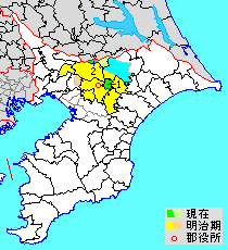
Inba District on:
[Wikipedia]
[Google]
[Amazon]

 is a
is a
 is a
is a district
A district is a type of administrative division that, in some countries, is managed by the local government. Across the world, areas known as "districts" vary greatly in size, spanning regions or counties, several municipalities, subdivisions o ...
located in Chiba Prefecture
is a prefecture of Japan located in the Kantō region of Honshu. Chiba Prefecture has a population of 6,278,060 (1 June 2019) and has a geographic area of . Chiba Prefecture borders Ibaraki Prefecture to the north, Saitama Prefecture to the ...
, Japan.
As of 2011, the district has an estimated population of 43,480 and a density
Density (volumetric mass density or specific mass) is the substance's mass per unit of volume. The symbol most often used for density is ''ρ'' (the lower case Greek letter rho), although the Latin letter ''D'' can also be used. Mathematical ...
of 845 persons per km2. The total area is 51.48 km2.
There are two towns within the district.
* Sakae
*Shisui
is a town located in Chiba Prefecture, Japan., the town had an estimated population of 20,660 in 9,888 households and a population density of 1100 persons per km². The total area of the town is .
Etymology
The name of Shisui in the Japanese l ...
District timeline
*January 1, 1957 - Parts ofYotsukaidō
is a city located in Chiba Prefecture, Japan. , the city had an estimated population of 95,266 in 43,191 households and a population density of 2800 persons per km². The total area of the city is .
Geography
Located inland on the Shimosa Plat ...
merged into the city of Sakura
A cherry blossom, also known as Japanese cherry or sakura, is a flower of many trees of Prunus, genus ''Prunus'' or Prunus subg. Cerasus, ''Prunus'' subg. ''Cerasus''. They are common species in East Asia, including China, Korea and especia ...
.
*September 1, 1964 - The village of Shiroi
is a city located in Chiba Prefecture, Japan. , the city had an estimated population of 63,190 in 26,204 households and a population density of 1800 persons per km². The total area of the city is . The name of the city comes from the word for ...
gained town status.
*April 1, 1981 - The town of Yotsukaidō gained city status.
*April 1, 1985 - The village of Tomisato
260px, Chiba Gas LNG storage tank in Tomisato
is a city located in Chiba Prefecture, Japan. , the city had an estimated population of 49,914 in 23,753 households and a population density of 930 persons per km2. The total area of the city is .
G ...
gained town status.
*April 1, 1992 - The town of Yachimata
260px, Peanut fields in Yachimata
is a city in Chiba Prefecture, Japan. , the city had an estimated population of 68,769 in 32,118 households and a population density of 920 persons per km². The total area of the city is .
Geography
Yachimata ...
gained city status.
*April 1, 1996 - The town of Inzai
file:Inzai city hall.JPG, 260px, Inzai City Hall
is a Cities of Japan, city located in Chiba Prefecture, Japan. , the city had an estimated population of 105,463 in 42,388 households and a population density of 850 persons per km². The total are ...
gained city status.
*April 1, 2001 - The town of Shiroi gained city status.
*April 1, 2002 - The town of Tomisato gained city status.
*March 23, 2010 - The villages of Inba and Motono merged into the city of Inzai
file:Inzai city hall.JPG, 260px, Inzai City Hall
is a Cities of Japan, city located in Chiba Prefecture, Japan. , the city had an estimated population of 105,463 in 42,388 households and a population density of 850 persons per km². The total are ...
.
Districts in Chiba Prefecture
{{Chiba-geo-stub