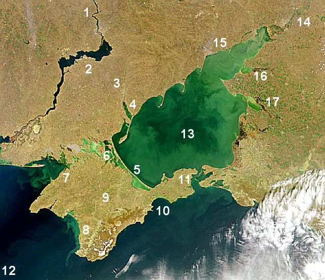
Gulf of Taganrog on:
[Wikipedia]
[Google]
[Amazon]
 Taganrog Bay (, uk, Таганрозька затока) is the northeastern arm of the Sea of Azov. It also may be perceived as a flooded


 Taganrog Bay (, uk, Таганрозька затока) is the northeastern arm of the Sea of Azov. It also may be perceived as a flooded
 estuary
An estuary is a partially enclosed coastal body of brackish water with one or more rivers or streams flowing into it, and with a free connection to the open sea. Estuaries form a transition zone between river environments and maritime environm ...
of the Don River
The Don ( rus, Дон, p=don) is the fifth-longest river in Europe. Flowing from Central Russia to the Sea of Azov in Southern Russia, it is one of Russia's largest rivers and played an important role for traders from the Byzantine Empire.
Its ...
.
Geography
The bay serves as a natural boundary between the Kuban coast line in Russia and the northern Azov littoral region in Ukraine and Russia. Since thefall of the Soviet Union
The dissolution of the Soviet Union, also negatively connoted as rus, Разва́л Сове́тского Сою́за, r=Razvál Sovétskogo Soyúza, ''Ruining of the Soviet Union''. was the process of internal disintegration within the Sov ...
, the international boundary here hasn't been established.
At its northeast end is the mouth of the Don River
The Don ( rus, Дон, p=don) is the fifth-longest river in Europe. Flowing from Central Russia to the Sea of Azov in Southern Russia, it is one of Russia's largest rivers and played an important role for traders from the Byzantine Empire.
Its ...
. Length: about , width at the mouth: , median depth: about . It may freeze some winters from December to March.
Three other rivers, the Kalmius
The Kalmius (, russian: Кальмиус) is one of two rivers flowing through the Ukrainian city of Mariupol. The other is the Kalchik, which flows into the Kalmius. The Kalmius flows into the Sea of Azov near the Azovstal steel manufacturing ...
, Mius
The Mius (, ) is a river in Eastern Europe that flows through Ukraine and Russia. It is long, and has a drainage basin of .Миус< ...
and the Yeya
The Yeya () is a river in Krasnodar Krai, Russia. It falls into the Yeya Firth of Taganrog Bay, Sea of Azov. It is long with a drainage basin of . It dries up in summer. The port town of Yeysk is located by the Yeya Firth at the neck of the Yeya S ...
, flow into the bay. The flow of water into the bay is the chief factor for current development in the Sea of Azov.


Landforms
Its mouth is marked by theDolgaya Spit
The Dolgaya Spit or Kosa Dolgaya (russian: Коса Долгая) is a sandy spit in the Sea of Azov.spits that partly enclose shallow bays. The bay contains "Sandy Isles" (Песчаные острова, Пісчані острови).
The major ports are
Taganrog
Taganrog ( rus, Таганрог, p=təɡɐnˈrok) is a port city in Rostov Oblast, Russia, on the north shore of the Taganrog Bay in the Sea of Azov, several kilometers west of the mouth of the Don River. Population:
History of Taganrog
Th ...
, Mariupol
Mariupol (, ; uk, Маріу́поль ; russian: Мариу́поль) is a city in Donetsk Oblast, Ukraine. It is situated on the northern coast ( Pryazovia) of the Sea of Azov, at the mouth of the Kalmius River. Prior to the 2022 Russia ...
(Ukraine
Ukraine ( uk, Україна, Ukraïna, ) is a country in Eastern Europe. It is the second-largest European country after Russia, which it borders to the east and northeast. Ukraine covers approximately . Prior to the ongoing Russian inv ...
), and Yeysk
Yeysk (russian: Ейск) is a port and a resort town in Krasnodar Krai, Russia, situated on the shore of the Taganrog Gulf of the Sea of Azov. The town is built primarily on the Yeysk Spit, which separates the Yeya River from the Sea of Azo ...
. Rostov-on-Don is a few miles up the Don river.
Water
The concentration of salt water in the Gulf is uneven. East, the most shallow part of the bay, which receives water directly to Don desalinized, and the westernmost osolonena, as is often subjected to the direct effects of Azov water. Taganrog Yeisk in Russia and Mariupol in the Ukraine are the main ports of Taganrog Bay. One strange phenomenon is the presence of both fresh and salt water in the bay. The water in the eastern and shallower part of the bay, which receives water from the Don River, is mostly desalinized. The western end of the bay is completely salt water.See also
* Don River BasinReferences
External links
Bays of the Sea of Azov Bays of Ukraine Russia–Ukraine border Bays of Krasnodar Krai Bodies of water of Rostov Oblast Don basin {{Donetsk-geo-stub