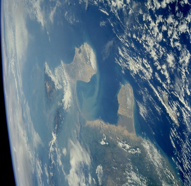
Gulf of Venezuela on:
[Wikipedia]
[Google]
[Amazon]
The Gulf of Venezuela is a gulf of the
 The gulf was first seen by Europeans in 1499, when an expedition commanded by
Caribbean Sea
The Caribbean Sea ( es, Mar Caribe; french: Mer des Caraïbes; ht, Lanmè Karayib; jam, Kiaribiyan Sii; nl, Caraïbische Zee; pap, Laman Karibe) is a sea of the Atlantic Ocean in the tropics of the Western Hemisphere. It is bounded by Mexico ...
bounded by the Venezuela
Venezuela (; ), officially the Bolivarian Republic of Venezuela ( es, link=no, República Bolivariana de Venezuela), is a country on the northern coast of South America, consisting of a continental landmass and many islands and islets in ...
n states of Zulia
Zulia State ( es, Estado Zulia, ; Wayuu: ''Mma’ipakat Suuria'') is one of the 23 states of Venezuela. The state capital is Maracaibo. As of the 2011 census, it has a population of 3,704,404, the largest population among Venezuela's states. It ...
and Falcón
)
, anthem =
, image_map = Falcon in Venezuela.svg
, map_alt =
, map_caption = Location within Venezuela
, pushpin_map =
, pushpin_map_alt =
, pushpin_mapsiz ...
and by La Guajira Department, Colombia. The western side is formed by the Guajira Peninsula. A strait connects it with Maracaibo Lake to the south.
Location
The Gulf is located in the north ofSouth America
South America is a continent entirely in the Western Hemisphere and mostly in the Southern Hemisphere, with a relatively small portion in the Northern Hemisphere at the northern tip of the continent. It can also be described as the souther ...
, between Paraguaná Peninsula of the Falcón State
)
, anthem =
, image_map = Falcon in Venezuela.svg
, map_alt =
, map_caption = Location within Venezuela
, pushpin_map =
, pushpin_map_alt =
, pushpin_mapsi ...
to the east in Venezuela and Guajira Peninsula in Colombia to the west. It is connected to the south to Maracaibo Lake through an artificial navigation canal
Canals or artificial waterways are waterways or engineered channels built for drainage management (e.g. flood control and irrigation) or for conveyancing water transport vehicles (e.g. water taxi). They carry free, calm surface fl ...
. Colombia and Venezuela have had a longstanding dispute over control of the gulf that has not been resolved, despite the decades-long negotiations conducted by a bilateral commission.
History
 The gulf was first seen by Europeans in 1499, when an expedition commanded by
 Alonso de Ojeda
Alonso de Ojeda (; c. 1466 – c. 1515) was a Spanish explorer, governor and conquistador. He travelled through modern-day Guyana, Venezuela, Trinidad, Tobago, Curaçao, Aruba and Colombia. He navigated with Amerigo Vespucci who is famous f ...
, in which he was accompanied by Amerigo Vespucci, explored the Venezuelan coasts. They compiled information and named the new lands; this expedition arrived at the gulf after passing through the Netherlands Antilles and the Peninsula of Paraguaná.
Economic importance
These waters are important because they connect theCaribbean Sea
The Caribbean Sea ( es, Mar Caribe; french: Mer des Caraïbes; ht, Lanmè Karayib; jam, Kiaribiyan Sii; nl, Caraïbische Zee; pap, Laman Karibe) is a sea of the Atlantic Ocean in the tropics of the Western Hemisphere. It is bounded by Mexico ...
to Lake Maracaibo
Lake Maracaibo ( Spanish: Lago de Maracaibo; Anu: Coquivacoa) is a lagoon in northwestern Venezuela, the largest lake in South America and one of the oldest on Earth, formed 36 million years ago in the Andes Mountains. The fault in the northern s ...
in Venezuela, an important source of crude petroleum. Their industry uses the gulf to ship products from their wells and refineries in Lake Maracaibo to the world markets.
See also
* El Calabozo cove Gulfs of VenezuelaVenezuela
Venezuela (; ), officially the Bolivarian Republic of Venezuela ( es, link=no, República Bolivariana de Venezuela), is a country on the northern coast of South America, consisting of a continental landmass and many islands and islets in ...
Geography of Zulia
Geography of La Guajira Department
{{Venezuela-geo-stub