Groothusen St Peter - Organ on:
[Wikipedia]
[Google]
[Amazon]
Groothusen is an old ''Langwurtendorf'' - a village on an artificially-built ridge - in the municipality of


 According to the
Groothusen parish
Photos and maps of Groothusen
{{Authority control Krummhörn Villages in Lower Saxony Towns and villages in East Frisia
Krummhörn
Krummhörn is a municipality in the district of Aurich, in Lower Saxony, Germany. It is situated near the Ems estuary, approximately 15 km southwest of Norden, and 10 km northwest of Emden.
The community (Gemeinde) of Krummhörn compr ...
in western East Frisia
East Frisia or East Friesland (german: Ostfriesland; ; stq, Aastfräislound) is a historic region in the northwest of Lower Saxony, Germany. It is primarily located on the western half of the East Frisian peninsula, to the east of West Frisia ...
on Germany's North Sea
The North Sea lies between Great Britain, Norway, Denmark, Germany, the Netherlands and Belgium. An epeiric sea on the European continental shelf, it connects to the Atlantic Ocean through the English Channel in the south and the Norwegian S ...
coast. It lies about 15 kilometres northwest of the seaport of Emden
Emden () is an independent city and seaport in Lower Saxony in the northwest of Germany, on the river Ems. It is the main city of the region of East Frisia and, in 2011, had a total population of 51,528.
History
The exact founding date of E ...
and has a population of 474 (as at: 31 December 2006). The ridge or ''warf
WARF (1350 AM) is a commercial radio station licensed to Akron, Ohio, known as "Fox Sports 1350 The Gambler" and carrying a sports format. Owned by iHeartMedia, WARF serves the Greater Cleveland and Akron metro areas as an affiliate of Fox Spor ...
'' has a length of about 500 metres and a width of some 130 metres and was built to raise the village above the water level should flooding from the sea occur e.g. during a storm tide
A storm surge, storm flood, tidal surge, or storm tide is a coastal flood or tsunami-like phenomenon of rising water commonly associated with low-pressure weather systems, such as cyclones. It is measured as the rise in water level above the no ...
.
History


 According to the
 urbarium
An urbarium (german: Urbar, English: ''urbarium'', also ''rental'' or ''rent-roll'', pl, urbarz, sk, urbár, hu, urbárium), is a register of fief ownership and includes the rights and benefits that the fief holder has over his serfs and peasant ...
from Werden Abbey
Werden Abbey (german: Kloster Werden) was a Benedictine monastery in Essen-Werden (Germany), situated on the Ruhr.
The foundation of the abbey
Near Essen Saint Ludger founded a monastery in 799 and became its first abbot. The little church w ...
, the village was first mentioned in the year 1000 under the name ''Husum'', but it had probably been established in the 8th century. Based on excavations carried out locally it can be inferred that it was probably a ''Wikdorf'' or trading post. It was laid out on a creek
A creek in North America and elsewhere, such as Australia, is a stream that is usually smaller than a river. In the British Isles it is a small tidal inlet.
Creek may also refer to:
People
* Creek people, also known as Muscogee, Native Americans
...
(''Priel'') that discharged into the so-called "Bay of Sielmönken" which has since completely silted up.
At that time it was only about 500 metres from the coast and therefore close to Frisia's maritime trading routes including the route between Dorestad
Dorestad (''Dorestat, Duristat'') was an early medieval emporium, located in the southeast of the province of Utrecht in the Netherlands, close to the modern-day town of Wijk bij Duurstede.
It flourished during the 8th to early 9th centuries, ...
and Haithabu
Hedeby (, Old Norse ''Heiðabýr'', German ''Haithabu'') was an important Danish Viking Age (8th to the 11th centuries) trading settlement near the southern end of the Jutland Peninsula, now in the Schleswig-Flensburg district of Schleswig-Holste ...
. Frisian merchants stacked their goods here and were accommodated in the village if they needed to stay for any length of time. After dykes were built in the 13th century Groothusen lost its importance as a trading post. Other ''Langwurtendorf'' villages in East Frisia are found near Groothusen including Grimersum (Krummhörn), Jemgum
Jemgum is a municipality in the Leer district, in the northwest of Lower Saxony, Germany. The area is known as ''Rheiderland'' (German) or ''Reiderland'' (Dutch). Rheiderland is located in East Friesland.
The East Friesland area of Germany (also ...
and Hatzum (Rheiderland
The Rheiderland is a region of Germany and the Netherlands between the River Ems and the Bay of Dollart. The German part of the Rheiderland lies in East Frisia, west of the Ems. The Dutch part (written: ''Reiderland'') lies in the Dutch provinc ...
), and in the centres of Oldersum (Moormerland
Moormerland is a municipality in the Leer District, in Lower Saxony, northwestern Germany
Germany,, officially the Federal Republic of Germany, is a country in Central Europe. It is the second most populous country in Europe after ...
) and in Nesse (Norder Marsch).
By the Early Middle Ages
The Early Middle Ages (or early medieval period), sometimes controversially referred to as the Dark Ages, is typically regarded by historians as lasting from the late 5th or early 6th century to the 10th century. They marked the start of the Mi ...
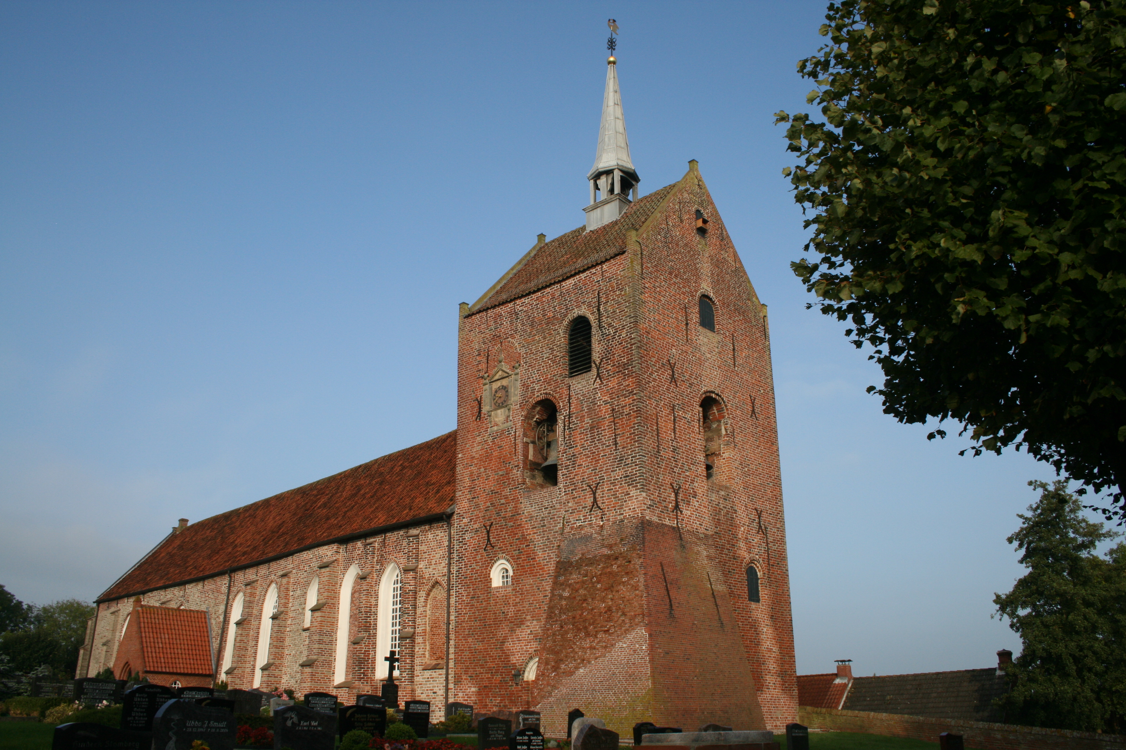
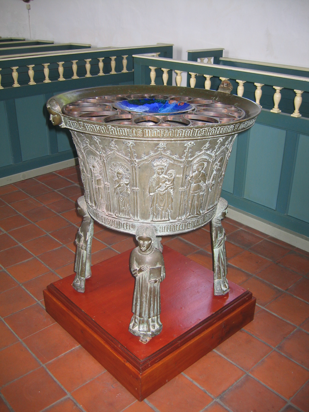
, Husum was the seat of a Münster provost (''Propstei''). The northwestern end of the long warf village is formed by the large St. Peter's Church, one of the six provost churches in the old Emsgau, with its huge tower. The bell dates to the year 1526. The gravestone of Adda von Meckenaborg, lady of Groothusen, from 1590, carved in blue stone is particularly fine. As well as other impressive graves, the church has a splendid 1454 cast bronze font by Ghert Klinghe and a valuable organ by Johann Friedrich Wenthin (1798-1801) with unique flute tones.
There were once three manor houses in Groothusen - the Osterburg, Middelburg and Westerburg. Only the Osterburg - rebuilt in 1490 - has been preserved; the other two were destroyed in feuds in 1400 and 1432 by Hamburg
(male), (female) en, Hamburger(s),
Hamburgian(s)
, timezone1 = Central (CET)
, utc_offset1 = +1
, timezone1_DST = Central (CEST)
, utc_offset1_DST = +2
, postal ...
's citizens. The Osterburg is on the eastern side of the village by a protected area
Protected areas or conservation areas are locations which receive protection because of their recognized natural, ecological or cultural values. There are several kinds of protected areas, which vary by level of protection depending on the ena ...
and has a long, historic lime
Lime commonly refers to:
* Lime (fruit), a green citrus fruit
* Lime (material), inorganic materials containing calcium, usually calcium oxide or calcium hydroxide
* Lime (color), a color between yellow and green
Lime may also refer to:
Botany ...
avenue. Today it houses numerous historical memorabilia.
Sources
* Kempe, Enno F. (1989). ''Die Osterburg zu Groothusen'' (Ostfriesischer Kunstführer, Heft 12). Aurich * Reinhardt, Waldemar (1959). ''Die Grabung auf der Dorfwarf von Groothusen, Kreis Norden, und ihre Ergebnisse''. In: Jahrbuch der Gesellschaft für bildende Kunst und vaterländische Altertümer zu Emden. Vol. 39, p. 30-36.External links
Groothusen parish
Photos and maps of Groothusen
{{Authority control Krummhörn Villages in Lower Saxony Towns and villages in East Frisia