Giorgio Sideri on:
[Wikipedia]
[Google]
[Amazon]
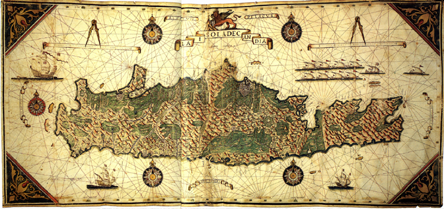
 Giorgio Sideri called Callapoda (fl. 1537–1565) was a 16th-century cartographer, born in Candia (
 Giorgio Sideri called Callapoda (fl. 1537–1565) was a 16th-century cartographer, born in Candia (
Crete
Crete ( el, Κρήτη, translit=, Modern: , Ancient: ) is the largest and most populous of the Greek islands, the 88th largest island in the world and the fifth largest island in the Mediterranean Sea, after Sicily, Sardinia, Cyprus, ...
), who worked in Venice
Venice ( ; it, Venezia ; vec, Venesia or ) is a city in northeastern Italy and the capital of the Veneto region. It is built on a group of 118 small islands that are separated by canals and linked by over 400 bridges. The isla ...
, where map-making skills were essential to the mercantile economy and to protection and control of the far-flung Venetian thalassocracy
A thalassocracy or thalattocracy sometimes also maritime empire, is a state with primarily maritime realms, an empire at sea, or a seaborne empire. Traditional thalassocracies seldom dominate interiors, even in their home territories. Examples ...
.
Four of his navigational chart
A nautical chart is a graphic representation of a sea area and adjacent coastal regions. Depending on the scale of the chart, it may show depths of water and heights of land (topographic map), natural features of the seabed, details of the coa ...
s and five hydrographical atlas
An atlas is a collection of maps; it is typically a bundle of maps of Earth or of a region of Earth.
Atlases have traditionally been bound into book form, but today many atlases are in multimedia formats. In addition to presenting geograp ...
es, often in ink and watercolor on parchment
Parchment is a writing material made from specially prepared untanned skins of animals—primarily sheep, calves, and goats. It has been used as a writing medium for over two millennia. Vellum is a finer quality parchment made from the skins o ...
are known; they bear dates ranging from 1537 to 1565 and several are dedicated to Venetian nobles.
Giorgio Sideri Callapoda came briefly into the news when his copy of a previously unknown fifteenth-century portolan chart
Portolan charts are nautical charts, first made in the 13th century in the Mediterranean basin and later expanded to include other regions. The word ''portolan'' comes from the Italian ''portulano'', meaning "related to ports or harbors", and wh ...
by Fra Mauro
Fra Mauro, O.S.B. Cam., (c.1400–1464) was a Venetian cartographer who lived in the Republic of Venice. He created the most detailed and accurate map of the world up until that time, the Fra Mauro map.
Mauro was a monk of the Camaldolese ...
was sold at auction in Milan, October 1984 at a price of 900 million Italian lira
The lira (; plural lire) was the currency of Italy between 1861 and 2002. It was first introduced by the Napoleonic Kingdom of Italy in 1807 at par with the French franc, and was subsequently adopted by the different states that would eventually ...
s.Ratti 1988:77-85.
It was signed in a cartouche ''Giorgi Callapoda a Candia faciebat'', and dated 1541; the coat-of-arms in the map shows that it was made for the Venetian commander of galleys Francesco Zeno the elder, a member of the noble Venetian family of Zeno.
Notes
{{Authority control Callapoda, Giorgio Sideri Year of birth missing Year of death missing 16th-century Venetian people