Georgia Gold Belt on:
[Wikipedia]
[Google]
[Amazon]
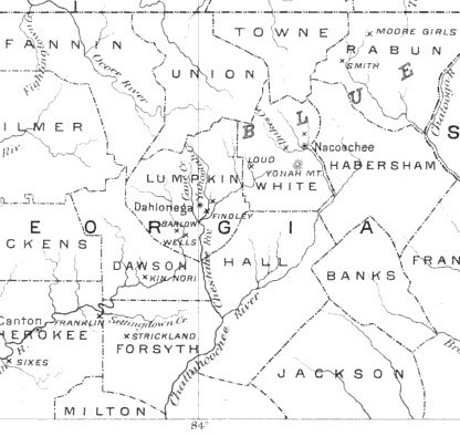
 The largest quantities of gold found in the eastern United States were found in the Georgia Gold Belt, extending from eastern Alabama to Rabun County, Georgia. The biggest concentration of gold was found in White, Lumpkin, and northern Cherokee counties in Georgia. The gold in the Georgia Gold Belt was close to 24 karat (100%) purity. Most of the gold was found in eroded rock (
'Thar's Gold in Them Thar Hills': Gold and Gold Mining in Georgia, 1830s-1940s
from the Digital Library of Georgia Geology of Georgia (U.S. state) Geography of Cherokee County, Georgia Geography of Lumpkin County, Georgia Geography of Rabun County, Georgia Geography of White County, Georgia Georgia Gold Rush Metallogenetic provinces Belt regions of the United States
 The largest quantities of gold found in the eastern United States were found in the Georgia Gold Belt, extending from eastern Alabama to Rabun County, Georgia. The biggest concentration of gold was found in White, Lumpkin, and northern Cherokee counties in Georgia. The gold in the Georgia Gold Belt was close to 24 karat (100%) purity. Most of the gold was found in eroded rock (
saprolite
Saprolite is a chemically weathered rock. Saprolites form in the lower zones of soil profiles and represent deep weathering of the bedrock surface. In most outcrops its color comes from ferric compounds. Deeply weathered profiles are widespread o ...
) and mixed in with quartz.
Besides placer deposits of gold, and gold bearing quartz in weathered rock, gold also occurs in quartz veins. The most profitable veins, in the Dahlonega District, occur in the contact zone between mica-schists and granite or diorite.Eckel, E.C. 1902, Gold and Pyrite Deposits of the Dahlonega District, Georgia, in Contributions to Economic Geology, USGS Bulletin No. 213, Washington: Government Printing Office
The discovery of gold in the Georgia Gold Belt in 1828 led to the Georgia Gold Rush. The historic cities of Auraria and Dahlonega were the primary beneficiaries of the gold discovery, and a branch mint of the United States Mint was operated in Dahlonega until 1861. The Georgia Gold Belt is part of a zone of gold deposits in the southeast United States that runs from Alabama to Virginia. Smaller gold deposits can be found farther north.
See also
* List of gold mines in GeorgiaReferences
{{reflistExternal links
'Thar's Gold in Them Thar Hills': Gold and Gold Mining in Georgia, 1830s-1940s
from the Digital Library of Georgia Geology of Georgia (U.S. state) Geography of Cherokee County, Georgia Geography of Lumpkin County, Georgia Geography of Rabun County, Georgia Geography of White County, Georgia Georgia Gold Rush Metallogenetic provinces Belt regions of the United States