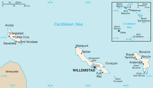
Geography Of The Netherlands Antilles on:
[Wikipedia]
[Google]
[Amazon]

 The Netherlands Antilles was a constituent country in the
''exclusive fishing zone:''
''territorial sea:'' Terrain: generally hilly, volcanic interiors Elevation extremes:
''lowest point:'' Caribbean Sea 0 m
''highest point:''
''arable land:'' 10%
''permanent crops:'' 0%
''permanent pastures:'' 0%
''forests and woodland:'' 0%
''other:'' 90% (1993 est.) Irrigated land: NA km² Natural hazards: Curaçao and Bonaire are south of Caribbean hurricane belt and are rarely threatened; Sint Maarten, Saba, and Sint Eustatius are subject to hurricanes from July to October. Environment - current issues: NA {{Geography of South America

Caribbean Sea
The Caribbean Sea ( es, Mar Caribe; french: Mer des Caraïbes; ht, Lanmè Karayib; jam, Kiaribiyan Sii; nl, Caraïbische Zee; pap, Laman Karibe) is a sea of the Atlantic Ocean in the tropics of the Western Hemisphere. It is bounded by Mexico ...
. It consisted of two island group
An archipelago ( ), sometimes called an island group or island chain, is a chain, cluster, or collection of islands, or sometimes a sea containing a small number of scattered islands.
Examples of archipelagos include: the Indonesian Archi ...
s, the ABC islands Curaçao, Bonaire and (until 1986) Aruba just north of Venezuela, and the SSS islands
The SSS islands (), locally also known as the Windward Islands ( or ), is a collective term for the three territories of the Dutch Caribbean (formerly the Netherlands Antilles) that are located within the Leeward Islands group of the Lesser Anti ...
east of the Virgin Islands
The Virgin Islands ( es, Islas Vírgenes) are an archipelago in the Caribbean Sea. They are geologically and biogeographically the easternmost part of the Greater Antilles, the northern islands belonging to the Puerto Rico Trench and St. Cro ...
.
The Netherlands Antilles had 960 km² (1153 km² before 1986) of land, which included no major lakes or other bodies of water.
Territory included the islands of Aruba until 1986 and Curaçao, Bonaire, Saba Saba may refer to:
Places
* Saba (island), an island of the Netherlands located in the Caribbean Sea
* Şaba (Romanian for Shabo), a town of the Odesa Oblast, Ukraine
* Sabá, a municipality in the department of Colón, Honduras
* Saba (river), ...
, Sint Eustatius, Sint Maarten
Sint Maarten () is a constituent country of the Kingdom of the Netherlands in the Caribbean. With a population of 41,486 as of January 2019 on an area of , it encompasses the southern 44% of the divided island of Saint Martin, while the nort ...
(which is the Dutch part of the island of Saint Martin) until 2010 when the Netherlands Antilles was dissolved. Its only land boundary was with France
France (), officially the French Republic ( ), is a country primarily located in Western Europe. It also comprises of overseas regions and territories in the Americas and the Atlantic, Pacific and Indian Oceans. Its metropolitan area ...
on the island of Saint Martin, which was 10.2 kilometers in length. The Netherlands Antilles had 364 kilometers (432 km before 1986) of coastline.
Climate
Tropical; ameliorated by northeast trade winds.Statistics
Maritime claims:''exclusive fishing zone:''
''territorial sea:'' Terrain: generally hilly, volcanic interiors Elevation extremes:
''lowest point:'' Caribbean Sea 0 m
''highest point:''
Mount Scenery
Mount Scenery is an active volcano in the Caribbean Netherlands. Its lava dome forms the summit of the Saba island stratovolcano. At an elevation of , it is the highest point in both the Kingdom of the Netherlands, and, since the dissolution o ...
Natural resources:
phosphates (Curaçao only), salt (Bonaire only)
Land use:
''arable land:'' 10%
''permanent crops:'' 0%
''permanent pastures:'' 0%
''forests and woodland:'' 0%
''other:'' 90% (1993 est.) Irrigated land: NA km² Natural hazards: Curaçao and Bonaire are south of Caribbean hurricane belt and are rarely threatened; Sint Maarten, Saba, and Sint Eustatius are subject to hurricanes from July to October. Environment - current issues: NA {{Geography of South America