Franklin Bay on:
[Wikipedia]
[Google]
[Amazon]
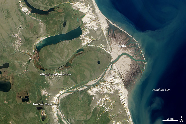
 Franklin Bay () is a large inlet in the
 Franklin Bay () is a large inlet in the
 Northwest Territories
The Northwest Territories (abbreviated ''NT'' or ''NWT''; french: Territoires du Nord-Ouest, formerly ''North-Western Territory'' and ''North-West Territories'' and namely shortened as ''Northwest Territory'') is a federal territory of Canada. ...
, Canada
Canada is a country in North America. Its ten provinces and three territories extend from the Atlantic Ocean to the Pacific Ocean and northward into the Arctic Ocean, covering over , making it the world's second-largest country by tot ...
. It is a southern arm of the Amundsen Gulf
Amundsen Gulf is a gulf located mainly in the Inuvik Region, Northwest Territories, Canada with a small section in the Kitikmeot Region of Nunavut. It lies between Banks Island and Victoria Island and the mainland. It is approximately in leng ...
, southeastern Beaufort Sea
The Beaufort Sea (; french: Mer de Beaufort, Iñupiaq: ''Taġiuq'') is a marginal sea of the Arctic Ocean, located north of the Northwest Territories, the Yukon, and Alaska, and west of Canada's Arctic islands. The sea is named after Sir Fr ...
. The bay measures long, and wide at its mouth. The Parry Peninsula
The Parry Peninsula on the north coast of Canada's Northwest Territories is bounded on the west by Franklin Bay, on the north by Amundsen Gulf, and on the east by Darnley Bay.The nearest settlement is Paulatuk. It is also home to the Cape Parry M ...
is to the east, and its southern area is called Langton Bay.
Franklin Bay receives the Horton River. There are gale
A gale is a strong wind; the word is typically used as a descriptor in nautical contexts. The U.S. National Weather Service defines a gale as sustained surface winds moving at a speed of between 34 and 47 knots (, or ).Arctic
The Arctic ( or ) is a polar regions of Earth, polar region located at the northernmost part of Earth. The Arctic consists of the Arctic Ocean, adjacent seas, and parts of Canada (Yukon, Northwest Territories, Nunavut), Danish Realm (Greenla ...
explorer Sir John Franklin
Sir John Franklin (16 April 1786 – 11 June 1847) was a British Royal Navy officer and Arctic explorer. After serving in wars against Napoleonic France and the United States, he led two expeditions into the Canadian Arctic and through ...
by John Richardson in 1826.
History
Based on hearsay rather than exploration,Émile Petitot
Émile-Fortuné Petitot (also known as Émile-Fortuné-Stanislas-Joseph Petitot) (Inuk name, ''Mitchi Pitchitork Tchikraynarm iyoyé'', meaning "Mr. Petitot, son of the Sun") (December 3, 1838 – May 13, 1916), a French Missionary Oblate, was a n ...
, a French Missionary Oblate and a notable Canadian northwest cartographer
Cartography (; from grc, χάρτης , "papyrus, sheet of paper, map"; and , "write") is the study and practice of making and using maps. Combining science, aesthetics and technique, cartography builds on the premise that reality (or an im ...
, ethnologist
Ethnology (from the grc-gre, ἔθνος, meaning 'nation') is an academic field that compares and analyzes the characteristics of different peoples and the relationships between them (compare cultural, social, or sociocultural anthropology) ...
, and geographer
A geographer is a physical scientist, social scientist or humanist whose area of study is geography, the study of Earth's natural environment and human society, including how society and nature interacts. The Greek prefix "geo" means "earth" a ...
charted the Hornaday River
Hornaday River (variants: Big River, Homaday River, Hornaaa River; or Rivière La Roncière-le Noury) is a waterway located above the Arctic Circle on the mainland of Northern Canada.
The upper reach of a river first discovered in 1868 was named R ...
's mouth at Franklin Bay, instead of Darnley Bay Darnley Bay is a large inlet in the Northwest Territories, Canada. It is a southern arm of the Amundsen Gulf. The bay measures long, and wide at its mouth.
The Parry Peninsula is to the west and Halcro Point is to the east. The Canadian Shiel ...
in his flawed 1875 maps and account.
Langton Bay was the base of operations for the three-year expedition, 1909 to 1912, of Arctic explorers Vilhjalmur Stefansson
Vilhjalmur Stefansson (November 3, 1879 – August 26, 1962) was an Arctic explorer and ethnologist. He was born in Manitoba, Canada.
Early life
Stefansson, born William Stephenson, was born at Arnes, Manitoba, Canada, in 1879. His parents had ...
and Rudolph Anderson
References
Bays of the Northwest Territories {{NorthwestTerritories-geo-stub