Foggathorpe on:
[Wikipedia]
[Google]
[Amazon]
Foggathorpe is a village and

 In 1892 '' Bulmer's History and Directory of East Yorkshire'' describes Foggathorpe as "a township containing of land lying on the bank of the Foulness river". It was described as a small village with a population of 113 in 1881, rising to 131 in 1891. The village had a station (on the
civil parish
In England, a civil parish is a type of administrative parish used for local government. It is a territorial designation which is the lowest tier of local government below districts and counties, or their combined form, the unitary authority ...
on the A163 road
List of A roads in zone 1 in Great Britain beginning north of the River Thames
The River Thames ( ), known alternatively in parts as the The Isis, River Isis, is a river that flows through southern England including London. At , it is ...
in the East Riding of Yorkshire
The East Riding of Yorkshire, or simply East Riding or East Yorkshire, is a ceremonial county and unitary authority area in the Yorkshire and the Humber region of England. It borders North Yorkshire to the north and west, South Yorkshire to t ...
, England. The village is situated approximately east of Selby
Selby is a market town and civil parish in the Selby District of North Yorkshire, England, south of York on the River Ouse, with a population at the 2011 census of 14,731.
The town was historically part of the West Riding of Yorkshire until ...
and west of Market Weighton
Market Weighton ( ) is a town and civil parish in the East Riding of Yorkshire, England. It is one of the main market towns in the East Yorkshire Wolds and lies midway between Hull and York, about from either one. According to the 2011 UK cen ...
.
The civil parish is formed by the villages of Foggathorpe and Laytham and the hamlet
''The Tragedy of Hamlet, Prince of Denmark'', often shortened to ''Hamlet'' (), is a tragedy written by William Shakespeare sometime between 1599 and 1601. It is Shakespeare's longest play, with 29,551 words. Set in Denmark, the play depicts ...
s of Harlthorpe and Gribthorpe.
According to the 2011 UK Census
A census of the population of the United Kingdom is taken every ten years. The 2011 census was held in all countries of the UK on 27 March 2011. It was the first UK census which could be completed online via the Internet. The Office for National ...
, Foggathorpe parish had a population of 313, an increase on the 2001 UK Census
A nationwide census, known as Census 2001, was conducted in the United Kingdom on Sunday, 29 April 2001. This was the 20th UK census and recorded a resident population of 58,789,194.
The 2001 UK census was organised by the Office for National ...
figure of 233.
There are about 35 houses in the centre of the village, a post office
A post office is a public facility and a retailer that provides mail services, such as accepting letters and parcels, providing post office boxes, and selling postage stamps, packaging, and stationery. Post offices may offer additional serv ...
in Station Road, a public house
A pub (short for public house) is a kind of drinking establishment which is licensed to serve alcoholic drinks for consumption on the premises. The term ''public house'' first appeared in the United Kingdom in late 17th century, and was ...
called the Black Swan, a nearby Hoseasons Holiday Park at Yellowtop Country Park, and a boarding kennels and cattery on the A163 main road.
History
In 1823 ''Baine's Directory'' recorded Foggathorpe as in the parish ofBubwith
Bubwith is a village and civil parish in the East Riding of Yorkshire, England. The village is situated about north-east of Selby, and south-east of York. It is situated on the east bank of the River Derwent, west of which is the Selby Distr ...
and the Wapentake
A hundred is an administrative division that is geographically part of a larger region. It was formerly used in England, Wales, some parts of the United States, Denmark, Southern Schleswig, Sweden, Finland, Norway, the Bishopric of Ösel–Wiek, C ...
of Harthill. Population was 137, with occupations including three farmers, a blacksmith
A blacksmith is a metalsmith who creates objects primarily from wrought iron or steel, but sometimes from #Other metals, other metals, by forging the metal, using tools to hammer, bend, and cut (cf. tinsmith). Blacksmiths produce objects such ...
, a wheelwright
A wheelwright is a craftsman who builds or repairs wooden wheels. The word is the combination of "wheel" and the word "wright", (which comes from the Old English word "''wryhta''", meaning a worker or shaper of wood) as in shipwright and arkw ...
, a grocer, and a shoemaker. A carrier operated between the village and York
York is a cathedral city with Roman origins, sited at the confluence of the rivers Ouse and Foss in North Yorkshire, England. It is the historic county town of Yorkshire. The city has many historic buildings and other structures, such as a ...
and Howden
Howden () is a market and minster town and civil parish in the East Riding of Yorkshire, England. It lies in the Vale of York to the north of the M62, on the A614 road about south-east of York and north of Goole, which lies across the Ri ...
once a week. At the time parcels of land were let to labourers for 'cow-gates' which resulted in a reduction in poor rate
In England and Wales the poor rate was a tax on property levied in each parish, which was used to provide poor relief. It was collected under both the Old Poor Law and the New Poor Law. It was absorbed into 'general rate' local taxation in the 19 ...
s.

 In 1892 '' Bulmer's History and Directory of East Yorkshire'' describes Foggathorpe as "a township containing of land lying on the bank of the Foulness river". It was described as a small village with a population of 113 in 1881, rising to 131 in 1891. The village had a station (on the
 Selby
Selby is a market town and civil parish in the Selby District of North Yorkshire, England, south of York on the River Ouse, with a population at the 2011 census of 14,731.
The town was historically part of the West Riding of Yorkshire until ...
and Market Weighton
Market Weighton ( ) is a town and civil parish in the East Riding of Yorkshire, England. It is one of the main market towns in the East Yorkshire Wolds and lies midway between Hull and York, about from either one. According to the 2011 UK cen ...
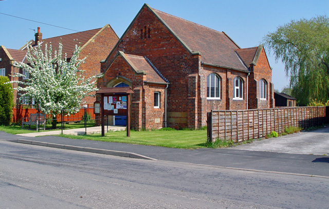
branch railway), and a Wesleyan chapel built in 1803 which was also used as a school for 41 children. Bulmer states that the village is called "Fulcathorpe" in the ''Domesday Book
Domesday Book () – the Middle English spelling of "Doomsday Book" – is a manuscript record of the "Great Survey" of much of England and parts of Wales completed in 1086 by order of King William I, known as William the Conqueror. The manusc ...
'' and that it was given by William I
William I; ang, WillelmI (Bates ''William the Conqueror'' p. 33– 9 September 1087), usually known as William the Conqueror and sometimes William the Bastard, was the first Norman king of England, reigning from 1066 until his death in 1087 ...
to his standard-bearer
A standard-bearer, also known as a flag-bearer is a person (soldier or civilian) who bears an emblem known as a standard or military colours, i.e. either a type of flag or an inflexible but mobile image, which is used (and often honoured) as a ...
, Gilbert Tison. Later the village belonged to the Aikroyds, one of whom was buried in the chancel of Bubwith church in 1673. The Aikroyds' old mansion was taken down in 1743, and a farmhouse erected on the site, though the mansion's moat
A moat is a deep, broad ditch, either dry or filled with water, that is dug and surrounds a castle, fortification, building or town, historically to provide it with a preliminary line of defence. In some places moats evolved into more extensive ...
remained. - viewed on internet document:
Geography
Foggathorpe gives its name to the local soil which is dominated by poorly drained,clay
Clay is a type of fine-grained natural soil material containing clay minerals (hydrous aluminium phyllosilicates, e.g. kaolin, Al2 Si2 O5( OH)4).
Clays develop plasticity when wet, due to a molecular film of water surrounding the clay par ...
ey soils of the ''Foggathorpe series''. Soils of both the ''Foggathorpe 1 Association'' and the ''Foggathorpe 2 Association'' are described as slowly permeable seasonally waterlogged stoneless clayey and fine loam
Loam (in geology and soil science) is soil composed mostly of sand (particle size > ), silt (particle size > ), and a smaller amount of clay (particle size < ). By weight, its mineral composition is about 40–40–20% concentration of sand–sil ...
y over clayey soils; the poor drainage and seasonal waterlogging creates conditions conducive to rapid surface runoff
Surface runoff (also known as overland flow) is the flow of water occurring on the ground surface when excess rainwater, stormwater, meltwater, or other sources, can no longer sufficiently rapidly infiltrate in the soil. This can occur when th ...
. The clay has its origins in glacial lake
A glacial lake is a body of water with origins from glacier activity. They are formed when a glacier erodes the land and then melts, filling the depression created by the glacier.
Formation
Near the end of the last glacial period, roughly 10,0 ...
s.
Transport
Foggathorpe had its ownrailway station
Rail transport (also known as train transport) is a means of transport that transfers passengers and goods on wheeled vehicles running on rails, which are incorporated in tracks. In contrast to road transport, where the vehicles run on a pre ...
from 1853 to 1954 on the Selby to Driffield Line
Selby is a market town and civil parish in the Selby District of North Yorkshire, England, south of York on the River Ouse, with a population at the 2011 census of 14,731.
The town was historically part of the West Riding of Yorkshire until ...
, and the site of the dismantled railway track runs to the south of the village. The nearest train service is now about ten minutes' drive away at Howden station, from which one can travel to London
London is the capital and largest city of England and the United Kingdom, with a population of just under 9 million. It stands on the River Thames in south-east England at the head of a estuary down to the North Sea, and has been a majo ...
Kings Cross. A bus service through Foggathorpe transports children to local schools.
References
*External links
* * {{authority control Villages in the East Riding of Yorkshire Civil parishes in the East Riding of Yorkshire