Flanking Line (meteorology) on:
[Wikipedia]
[Google]
[Amazon]
 A flanking line is an area of
 A flanking line is an area of
 cumulus congestus
Cumulus congestus clouds, also known as towering cumulus, are a form of cumulus that can be based in the low or middle height ranges. They achieve considerable vertical development in areas of deep, moist convection. They are an intermediate stage ...
or small cumulonimbus
Cumulonimbus (from Latin ''cumulus'', "heaped" and ''nimbus'', "rainstorm") is a dense, towering vertical cloud, typically forming from water vapor condensing in the lower troposphere that builds upward carried by powerful buoyant air currents. ...
that mark an area of widespread updrafts on the edge of strong thunderstorms. These flanking lines generally occur in the vicinity of supercell thunderstorms or large multicell thunderstorms.
Structure of a flanking line
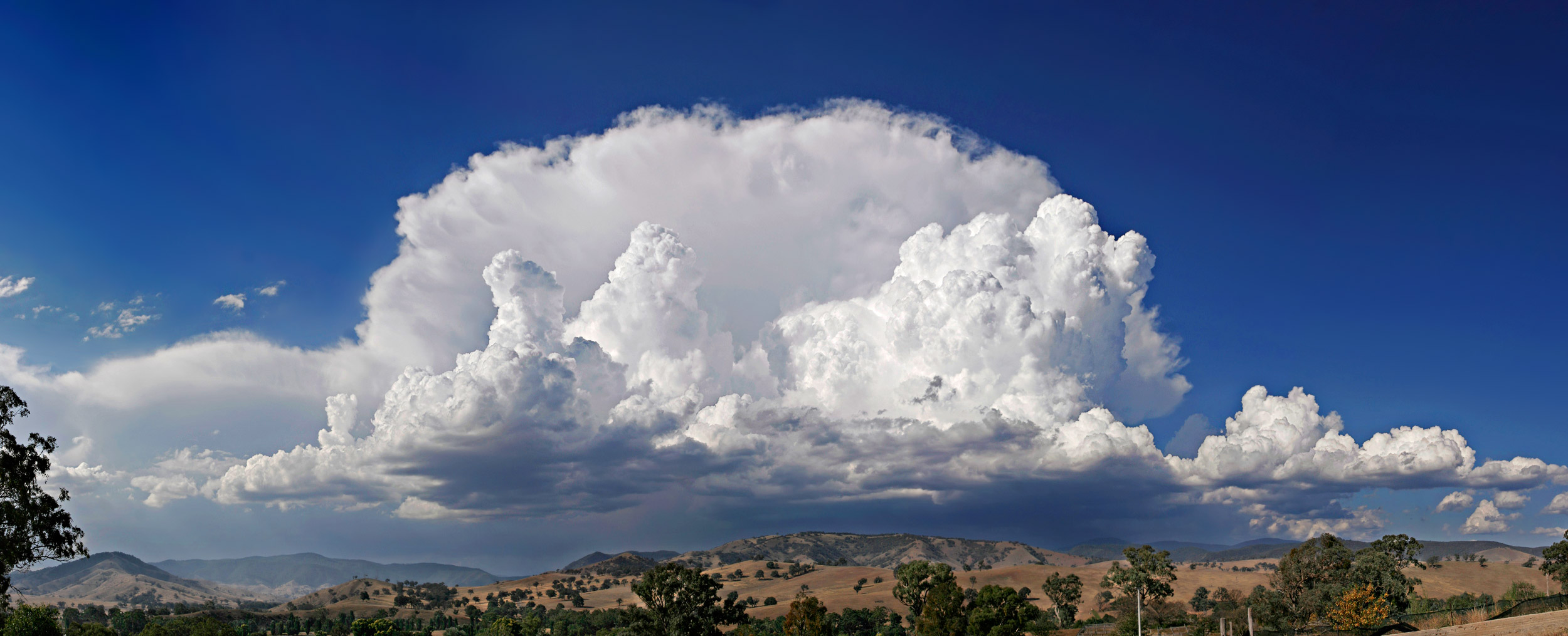
A flanking line often has a stairstep appearance where the tallest cells are connected to the main cumulonimbus. The bases of the clouds making the flanking line are merged. The forefront area usually has noprecipitation
In meteorology, precipitation is any product of the condensation of atmospheric water vapor that falls under gravitational pull from clouds. The main forms of precipitation include drizzle, rain, sleet, snow, ice pellets, graupel and hail. ...
. In the picture, it is possible to detect precipitation in the background just above the horizon below the main cloud.
Formation of the flanking line
The flanking line is generated by thedownburst
In meteorology, a downburst is a strong downward and outward gushing wind system that emanates from a point source above and blows radially, that is, in straight lines in all directions from the area of impact at surface level. Capable of pro ...
that builds a cold air wedge beneath the warmer airmass in front of the thunderstorm. This warm air is forced upward and generates cumuliform clouds when the air column becomes saturated.
These feeder clouds will merge with the main cumulonimbus and will regenerate the storm. These new feeder clouds are located, in the northern hemisphere, at the west or southwest of the main cloud.
Since these updrafts do not originate from the ground, the lifted condensation level
The lifted condensation level or lifting condensation level (LCL) is formally defined as the height at which the relative humidity (RH) of an air parcel will reach 100% with respect to liquid water when it is cooled by dry adiabatic lifting. The ...
will be higher than the convective condensation level The convective condensation level (CCL) represents the height (or pressure) where an air parcel becomes saturated when heated from below and lifted adiabatically due to buoyancy.
In the atmosphere, assuming a constant water vapor mixing ratio, th ...
associated with the main cumulonimbus. The cloud base of the flanking line is higher than the main cloud base. When the difference between these two levels increases, it indicates that the downburst has become stronger and thus that the severity of the thunderstorm has increased.
Soaring
A widespread misconception in the world of soaring is that the updrafts associated with an incoming thunderstorm are almost always very strong and turbulent, ''which is most of the time incorrect''. If one believes this myth, then he would consider it safe (from thunderstorms, at least) to fly in an area with plentiful weak to moderate updrafts, since the updrafts associated with thunderstorms are always supposed to be strong and turbulent. In fact, the turbulence zone is located in and at the vicinity of the downdraft. The updrafts under the flanking line are smooth. The refutation of this myth is poetically expressed by Dominique Musto who says the following: The author means that when flying under a flanking line, the updrafts will be widespread and smooth. Since the cells making the flanking line will fuse with the main cell, the soaring conditions will "improve", the updrafts will become stronger and stronger and the cloud base will become darker and darker. Another clue of imminent danger is that the cloud base is ''significantly higher'' than the theoretical cloud base based on the difference between the temperature anddew point
The dew point is the temperature to which air must be cooled to become saturated with water vapor, assuming constant air pressure and water content. When cooled below the dew point, moisture capacity is reduced and airborne water vapor will cond ...
on the ground. Eventually, the pilot may inadvertently fly under the main cell. If the pilot ignores these harbingers, he may hit a tornado
A tornado is a violently rotating column of air that is in contact with both the surface of the Earth and a cumulonimbus cloud or, in rare cases, the base of a cumulus cloud. It is often referred to as a twister, whirlwind or cyclone, altho ...
generated under a wall cloud
A wall cloud (murus or pedestal cloud) is a large, localized, persistent, and often abrupt lowering of cloud that develops beneath the surrounding base of a cumulonimbus cloud and from which tornadoes sometimes form. It is typically beneath the r ...
and disintegrate his fragile skiff.
Notwithstanding the aforementioned, Dennis Pagen experimented the exploitation of a flanking line (that he calls a ''bench'') with a hang glider
Hang gliding is an air sport or recreational activity in which a pilot flies a light, non-motorised foot-launched heavier-than-air aircraft called a hang glider. Most modern hang gliders are made of an aluminium alloy or composite frame cover ...
along a severe thunderstorm. He was able to fly at high speed for . This flight was performed during the preliminaries of the 1990 hang glider world championship in Brazil
Brazil ( pt, Brasil; ), officially the Federative Republic of Brazil (Portuguese: ), is the largest country in both South America and Latin America. At and with over 217 million people, Brazil is the world's fifth-largest country by area ...
. The author admits that this achievement was dubious.
References
{{reflistSee also
*Cumulonimbus
Cumulonimbus (from Latin ''cumulus'', "heaped" and ''nimbus'', "rainstorm") is a dense, towering vertical cloud, typically forming from water vapor condensing in the lower troposphere that builds upward carried by powerful buoyant air currents. ...
* Cumulonimbus and aviation
Numerous accidents have occurred in the vicinity of thunderstorms due to the density of clouds. It is often said that the turbulence can be extreme enough inside a cumulonimbus to tear an aircraft into pieces, and even strong enough to hold a sky ...
Aeronautics
Clouds
Gliding technology
Severe weather and convection