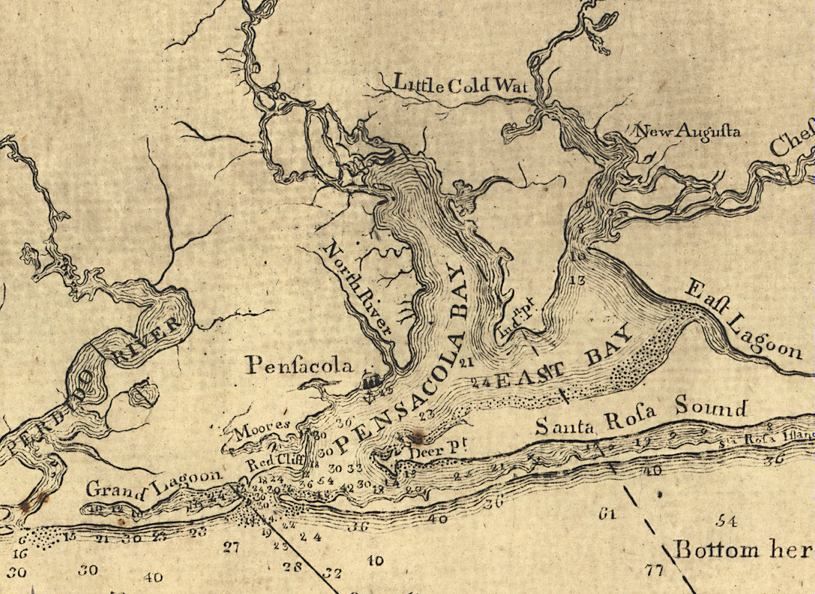
East Bay (Santa Rosa County, Florida) on:
[Wikipedia]
[Google]
[Amazon]
East Bay is a
 European exploration of the bay likely occurred as early as Pensacola's establishment in the early 16th century.
The bay has been included in most major maps of the bay system and harbor, dating back to that era. Between its first mapping and the present day, the bay has been listed under several different names, primarily Oyster Cove, Galvez Bay, and East Bay.
During
bay
A bay is a recessed, coastal body of water that directly connects to a larger main body of water, such as an ocean, a lake, or another bay. A large bay is usually called a ''gulf'', ''sea'', ''sound'', or ''bight''. A ''cove'' is a small, ci ...
located in the far western Florida Panhandle
The Florida panhandle (also known as West Florida and Northwest Florida) is the northwestern part of the U.S. state of Florida. It is a Salient (geography), salient roughly long, bordered by Alabama on the west and north, Georgia (U.S. state ...
. Unusually, East Bay is connected to open waters via Pensacola Bay
Pensacola Bay is a bay located in the northwestern part of Florida, United States, known as the Florida Panhandle.
The bay, an inlet of the Gulf of Mexico, is located in Escambia County and Santa Rosa County, adjacent to the city of Pensac ...
to its southwest. The bay is fed primarily by the Blackwater River
A blackwater river is a type of River#Classification, river with a slow-moving channel flowing through forested swamps or wetlands. Most major blackwater rivers are in the Amazon Basin and the Southern United States. The term is used in fluvial ...
and the East Bay River
The East Bay River (also called the East River and historically known as The River Jordan or the Chester River) in Florida is a U.S. Geological Survey. National Hydrography Dataset high-resolution flowline dataThe National Map , accessed April 15 ...
.
East Lagoon
The east side of East Bay is pinched into a wide river-like shape (often referred to as East Lagoon on historical maps, though the name is no longer commonly used) until eventually becoming an actual river atEast Bay River
The East Bay River (also called the East River and historically known as The River Jordan or the Chester River) in Florida is a U.S. Geological Survey. National Hydrography Dataset high-resolution flowline dataThe National Map , accessed April 15 ...
. The Lagoon starts where the bay is met by Axelson Point and Miller Point
Casey Inlet () is an ice-filled inlet at the terminus of Casey Glacier, between Miller Point and Cape Walcott, on the east coast of Palmer Land, Antarctica.
Location
Casey Inlet is on the Wilkins Coast of Palmer Land on the Antarctic Peninsul ...
.
History
 European exploration of the bay likely occurred as early as Pensacola's establishment in the early 16th century.
The bay has been included in most major maps of the bay system and harbor, dating back to that era. Between its first mapping and the present day, the bay has been listed under several different names, primarily Oyster Cove, Galvez Bay, and East Bay.
During
 Hurricane Ivan
Hurricane Ivan was a large, long-lived, and devastating tropical cyclone that caused widespread damage in the Caribbean and United States. The ninth named storm, the sixth hurricane, and the fourth major hurricane of the active 2004 Atlantic h ...
's landfall in September 2004, the storm surge
A storm surge, storm flood, tidal surge, or storm tide is a coastal flood or tsunami-like phenomenon of rising water commonly associated with low-pressure weather systems, such as cyclones. It is measured as the rise in water level above the ...
from the Gulf of Mexico
The Gulf of Mexico () is an oceanic basin and a marginal sea of the Atlantic Ocean, mostly surrounded by the North American continent. It is bounded on the northeast, north, and northwest by the Gulf Coast of the United States; on the southw ...
came into East Bay, flooding the shoreline of the bay.
References
Bays of Florida on the Gulf of Mexico Bodies of water of Santa Rosa County, Florida Navarre, Florida {{SantaRosaCountyFL-geo-stub