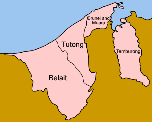
Districts Of Brunei on:
[Wikipedia]
[Google]
[Amazon]

Districts of Brunei on Statoids.com
Subdivisions of Brunei Brunei, Districts Brunei 1 Districts, Brunei Brunei geography-related lists {{Brunei-geo-stub
Districts
A district is a type of administrative division that, in some countries, is managed by the local government. Across the world, areas known as "districts" vary greatly in size, spanning regions or counties, several municipalities, subdivisions o ...
() are the principal administrative divisions
Administrative division, administrative unit,Article 3(1). country subdivision, administrative region, subnational entity, constituent state, as well as many similar terms, are generic names for geographical areas into which a particular, ind ...
of Brunei
Brunei ( , ), formally Brunei Darussalam ( ms, Negara Brunei Darussalam, Jawi alphabet, Jawi: , ), is a country located on the north coast of the island of Borneo in Southeast Asia. Apart from its South China Sea coast, it is completely sur ...
. The country is divided into four districts, namely Brunei-Muara, Belait, Tutong and Temburong
Temburong District ( ms, Daerah Temburong; Jawi: دائيره تمبوروڠ) or simply Temburong () is the easternmost district in Brunei. It is an exclave — the land is separated from the rest of the country by Malaysia and Brunei Bay, and ...
. Temburong is an exclave
An enclave is a territory (or a small territory apart of a larger one) that is entirely surrounded by the territory of one other state or entity. Enclaves may also exist within territorial waters. ''Enclave'' is sometimes used improperly to deno ...
; it is physically separated from the three other districts by the Brunei Bay and Malaysian state
The states and federal territories of Malaysia are the principal administrative divisions of Malaysia. Malaysia is a federation of 13 states (''Negeri'') and 3 federal territories (''Wilayah Persekutuan'').
States and federal territories
Ele ...
of Sarawak
Sarawak (; ) is a States and federal territories of Malaysia, state of Malaysia. The largest among the 13 states, with an area almost equal to that of Peninsular Malaysia, Sarawak is located in northwest Borneo Island, and is bordered by the M ...
. Each district has a town as its administrative and main economic centre, with the exception of Brunei-Muara, where the principal centre is Bandar Seri Begawan
Bandar Seri Begawan (BSB; Jawi: بندر سري بڬاوان; ) is the capital city of Brunei. It is officially a municipal area () with an area of and an estimated population of 100,700 as of 2007. It is part of Brunei-Muara District, the sm ...
, a city and the country's capital.
History
The country previously had six districts, namely Brunei, Muara, Limau Manis (also known as Ulu Brunei), Tutong, Belait and Temburong. In 1908 Brunei and Limau Manis were merged, and in 1938 the districts were restructured to form the present-day four districts.Administration
Each district is administered by a District Office (), where District Offices are government departments under theMinistry of Home Affairs
An interior ministry (sometimes called a ministry of internal affairs or ministry of home affairs) is a government department that is responsible for internal affairs.
Lists of current ministries of internal affairs
Named "ministry"
* Ministry ...
. The head of each department is a District Officer () and appointed by the government.
A district is further divided into mukims, and subsequently each mukim consists of several villages
A village is a clustered human settlement or community, larger than a hamlet but smaller than a town (although the word is often used to describe both hamlets and smaller towns), with a population typically ranging from a few hundred to ...
(). Each District Office manages the mukims and villages within its district.
The districts

See also
* ISO 3166-2:BNReferences
*External links
Districts of Brunei on Statoids.com
Subdivisions of Brunei Brunei, Districts Brunei 1 Districts, Brunei Brunei geography-related lists {{Brunei-geo-stub